| CEMETERY NAME |
CREATED |
NOTES |
| Adams Cemetery |
|
See Doak cemetery for burials. |
| Aikin Grove Cemetery |
16 Feb 1905 |
This cemetery is located in the southwest quadrant
of Red River County, Texas. GPS COORDINATES: Datum WGS84: 33 Deg 33.305N, 95
Deg 02.952W. This cemetery is located at the Aikin Grove Missionary Baptist
Church 4 miles south of Clarksville on FM 910. On 5 Mar 1897, Mr. J. D. Aikin
et ux, sold two acres of the J. C. Heart Survey to the Baptist Church and the
Methodist Episcopal Church South and School for the sum of $10.00. The oldest
marked grave is that of Dollie Maxwell, wife of J. E., who died 16 Feb 1905.
This cemetery was surveyed by Lawrence and Sue Dale on Wednesday, 9 Dec 1998.
We were on this site again on 19 Dec 2003 to do a complete rewalk of the cemetery
and to take the GPS Coordinates. As of 31 Dec 2004 this cemetery had 201 documented
burials. This cemetery was completely reworked on 28 Jan 2011 and pictures taken
of all markers. This new information was then added into the existing records
by Lawrence and Sue Dale. These pictures were then placed on Findagrave attached
to the appropriate memorial. As of 31 Dec 2013 this cemetery had 213 documented
burials. |
| Albion Cemetery |
5 Oct 1863 |
This cemetery is located
in the northwest quadrant of Red River County, Texas. GPS COORDINATES: Datum
WGS84: 33 Deg 50.877N, 95 Deg 02.041W. Albion Cemetery is located on Hwy 37
south 8/10 of a mile from the Red River and west 2/10 of a mile on a little
side road on the George S. Park headright survey. The oldest marked grave is
that of George W. Haley who died 5 Oct 1863. On a muddy day, 3 March 1997, this
cemetery was surveyed by Lawrence and Sue Dale. On 3 Feb 2003 we returned to
this site and recorded the GPS Coordinates for this cemetery. We also did a
re-walk of the cemetery adding new burials and noting marker changes. As of
31 Dec 2004 this cemetery had 211 documented burials. As of 31 Dec 2013 this
cemetery had 226 documented burials. |
| Allen Ranch Cemetery |
3 Sep 2010
|
This family is first mentioned in the obituary for Charles Clifford Allen
in The Clarksville Times dated 23 Sep 2010. We have not found this burial ground
to date. There is only the one burial as of 31 Dec 2013. |
| Annona Cemetery |
3 Oct 1886 |
This cemetery is located in the southeast quadrant of Red
River County, Texas. GPS COORDINATES: Datum WGS84: 33 Deg 34.632N, 94 Deg 55.041W.
The Annona Cemetery is in the south side of Annona. From Hwy 82 in Annona at
the intersection with FM 44, proceed south into old downtown Annona, pass the
old railroad right-of-way and bear right continuing down Booth Blvd. Go about
two to three city blocks and again bear right down a narrow track heading generally
south. After one city block, Annona Cemetery is on the right. The earliest land
record to be found was a purchase from Sam Fuller on 10 Feb 1942. The Annona
Cemetery Society paid Gertrude B. Wooten, widow of D. C., $1 for a plot 30 x
164 feet and 3-1/4 acres out of the J. D. Lawson headright survey. The earliest
marked grave is that of Mary J. Lawson, Wife of I. H., who died 3 Oct 1886.
This cemetery was surveyed by Lawrence and Sue Dale on 24 Jan 1999. We again
visited this site on 10 Jan 2004 to take the GPS Coordinates. We also did a
re-walk of the cemetery adding new burials and noting marker changes. As of
31 Dec 2004 this cemetery had 464 documented burials. This cemetery was completely
walked by Richard L. and Gertrud (Rodemers) Hankins in December of 2010 and
pictures were taken of all markers. This information was then added into existing
records and all information updated by Lawrence and Sue Dale. These pictures
were then placed on Findagrave attached to the appropriate memorial. As of 31
Dec 2013 this cemetery had 485 documented burials. |
| Annona Black Cemetery |
|
See Rock of Ages B cemetery for burials |
| Antioch Black Cemetery |
|
See Reed B cemetery for burials |
| Avery Cemetery |
10 Feb 1904 |
This cemetery is located in the southeast quadrant of Red
River County, Texas. GPS COORDINATES: Datum WGS84: 33 Deg 32.843N, 94 Deg
47.345W. This cemetery is located on the west side of Avery just south of
the railroad on the William Collum Survey. The oldest surviving marked grave
is that of Jesse Sutton Ingram who died on 10 Feb 1904. The work on this
cemetery was started on 18 Oct 1999 by Lawrence and Sue Dale. As we recorded
the information on this cemetery we also divided the cemetery into 9 Sections
with Section 1, the original burial area, containing 307 graves. There is
provision for expansion as a Avery Cemetery new section, the Bearden Addition,
is already under fence and plots are being sold. This cemetery stands out
for its cleanliness and for the future planned controlled expansion of its
facilities. This work was completed on 22 Oct 1999 after a hard five days.
We went there again on 30 Jan 2003 and took the GPS Coordinates. We also
did a re-walk of the cemetery on 4 May 2004 adding new burials and noting
marker changes. As of 31 Dec 2004 this cemetery had 1598 documented burials.
This cemetery was completely walked by Richard L. and Gertrud (Rodemers)
Hankins in early 2011 and pictures were taken of all markers. This information
was then added into existing records and all information updated by Lawrence
and Sue Dale. These pictures were then placed on Findagrave attached to
the appropriate memorial. As of 31 Dec 2013 this cemetery had 1783 documented
burials. Avery Cemetery Map |
| Bachman Cemetery |
29 Nov 1882 |
This cemetery is located in the northeast
quadrant of Red River County, Texas. GPS COORDINATES: Datum WGS84: 33 Deg 46.698N,
94 Deg 55.530W. From east of Clarksville on Hwy 82, take FM 1159 15.0 miles
to its junction with Collier Creek east of Acworth. The cemetery appears to
be situated on the Patsey Kitchens survey and the cemetery is directly on the
creek to the southeast of this junction. There is a pasture gate so be sure
to observe all country courtesies upon entering and leaving. The oldest marked
grave is that of Marshall N. Bachman who died on 29 Nov 1882. This cemetery
was surveyed by Lawrence and Sue Dale on 18 Jan 1999. We visited the site again
on 8 Dec 2003 and took the GPS readings. We also did a re-walk of the cemetery
adding new burials and noting marker changes. As of 29 Feb 2012 this cemetery
had 61 documented burials. This cemetery was again worked on 30 Jan 2011 by
Lawrence and Sue Dale and pictures made of all markers that were in place as
of that date. These pictures were then placed on Findagrave attached to the
appropriate memorial. As of 31 Dec 2013 this cemetery had 65 documented burials. |
| Bagwell Black Cemetery |
23 Mar 1895 |
Bagwell Black Cemetery, is an old
abandoned Afro-American Cemetery, having its first recorded burial on 23 Mar
1895 with the last burial taking place on 28 Nov 1963. Since this date there
have been no burials and the only access to the cemetery is on foot. We have
not been able to find a church associated with this burial ground. This cemetery
is located in the northwest quadrant of Red River County, Texas. GPS COORDINATES:
Datum WGS84: 33 Deg 40.338N, 95 Deg 08.536W. From FM 2168 in Bagwell, take CR
2110 for 1.1 miles to CR 2111. Take CR 2111 north for 1.5 miles and turn into
the drive to James Miller residence, another .5 miles. The cemetery is on this
property and about 3/4 mile to the southeast. This is definitely a woods type
cemetery and there is evidence of many other burials there, including at least
the remnants of 5 other funeral home markers with no information. The oldest
marked burial is that of Paul Needham Prewett, Jr. who died on 23 Mar 1895.
On a warm fall day, 22 Nov 2003, Lawrence and Sue Dale visited the site and
recorded the burials there. As of 31 Dec 2013 this cemetery has 33 documented
burials. |
| Bailey Cemetery |
16 Oct 1883 |
This cemetery is located
in the northwest quadrant of Red River County, Texas. GPS COORDINATES: Datum
WGS84: 33 Deg 54.885N, 95 Deg 09.110W. This cemetery is in northwest RRCo TX
and not shown on any of the maps of the area. From FM 410 and its intersection
with CR 2353 take CR 2353 south 8/10 mile till you cross a slough area. There
is a line of trees along the slough. By following the tree line for about 250
yards southeasterly to a stand of 4 pecan trees and then entering the woods
in a southeasterly direction the cemetery can be seen. Do not confuse this cemetery
with the Old Siloam cemetery as they are separate entities. The oldest marked
burial is that of Susan Degraffenried who died on 16 Oct 1883. The name Bailey
was confirmed separately by two individuals, Robert Williams, living on the
Red River, and Mrs Love who lives in the Siloam Community. This cemetery was
surveyed by Lawrence and Sue Dale on 23 Jan 2000. We visited the site again
on 6 Dec 2003 and took the GPS readings. This cemetery was again worked on 24
Jan 2013 by Lawrence and Sue Dale and pictures made of all markers that were
in place as of that date. These pictures were then placed on Findagrave attached
to the appropriate memorial. As of 31 Dec 2013 this cemetery had 14 documented
burials. |
| Bailey Black Cemetery |
|
See Old Siloam B cemetery for burials |
| Baker Family Cemetery |
27 Mar 1909 |
This cemetery is located in the
southeast quadrant of Red River County, Texas. GPS COORDINATES: Datum WGS84:
33 Deg 26.856N, 94 Deg 45.266W. El 375 ft. This is a small family cemetery across
the road from the Lydia Cemetery. It is on part of the Sewell Hancock headright
survey. It is well cared for and heavily fenced on the edge of the old church
property. The oldest marked burial is that of Myrtle Baker who died on 27 Mar
1909. This cemetery was surveyed by Lawrence and Sue Dale on 8 Jan 1999. We
visited the site again on 18 Dec 2003 and took the GPS readings. This cemetery
was again worked on 8 Dec 2012 by Lawrence and Sue Dale and pictures made of
all markers that were in place as of that date. These pictures were then placed
on Findagrave attached to the appropriate memorial. As of 31 Dec 2013 this cemetery
had 5 documented burials. |
| Baptist Cemetery |
|
See Clarksville cemetery for burials |
| Baptist Black Cemetery |
|
See Hebron B cemetery for burials |
| Barnesville Black Cemetery |
10 Sep 1885 |
This cemetery is located in the northwest
quadrant of Red River County, Texas. GPS COORDINATES: Datum WGS84: 33 Deg 55.581N,
95 Deg 12.588W. From Woodland take FM 410 north for 12.8 miles to the intersection
with CR 2356. Take CR 2356 south for 6/10 mile south to CR 2355. Take CR 2355
west for 7/10 mile and you are in the cemetery. It is at the northwestern edge
of the Garland Geer Survey. A deed to Barnesville Missionary Baptist Church
from Rev. E. Barnes, Sr., conveys 1 acre of the John Askey survey, this instrument
made on 28 May 1886 and filed on 29 May 1886, being duly recorded in Book CH
Vol 10 Page 288. This is a black cemetery and the oldest marker was that of
Clarsa Barnes who died 10 Sep 1885. This cemetery was surveyed by Lawrence and
Sue Dale on 21 Feb 1999. While revisiting the site on 24 Jan 2000, we found
a new site marker as follows: Barnesville Baptist Church and Cemetery, established
Nov 1867, Rev. Elisah Barnes, Dedicated To The Members That Attended Barnesville
Baptist Church, To All The Families That Have Loved Ones Buried In This Cemetery,
Forever In Our Hearts, Church Closed 2 Nov 1990. We visited the site again on
6 Dec 2003 and took the GPS readings. We also did a re-walk of the cemetery
adding new burials and noting marker changes. This cemetery was again worked
on 23 Jan 2013 by Lawrence and Sue Dale and pictures made of all markers that
were in place as of that date. These pictures were then placed on Findagrave
attached to the appropriate memorial. As of 31 Dec 2013 this cemetery had 163
documented burials. |
| Bartonville Black Cemetery |
|
See Barnesville B cemetery for burials |
| Becknell Cemetery |
1865 |
This cemetery is located
in the southwest quadrant of Red River County, Texas. GPS COORDINATES: Datum
WGS84: 33 Deg 37.691N, 95 Deg 10.153W. This cemetery is located about 6 miles
west of Clarksville, the first branch bottom east of the roadside park on Hwy.
82. It is about 150 yards south of the highway in a field on the William Becknell
Survey. On 20 Dec 1861 there is a deed from Mary Becknell to Methodist Episcopal
Church for 6 acres SW corner Becknells Prairie and filed for record on 24 Dec
1861 in Book CH N page 457. There is a conveyance of a 1 acre tract on the west
side of Becknell's Prairie from W. W. Scaff to the Becknell West School Commission
made on 14 Sep 1882 and filed for record on 2 May 1883 in Book CH Vol 5 Page
401. There are signs of recent brush cutting and general clean-up to the area.
This cemetery was surveyed by Lawrence and Sue Dale on 24 Jan 1999. We walked
through the briers on 21 Jan 2003 to again visit and to find no more cleanup
has been done on this historic site. We took the GPS Coordinates while there
this time. This cemetery was again worked on 21 Nov 2013 by Lawrence and Sue
Dale and pictures made of all markers that were in place as of that date. These
pictures were then placed on Findagrave attached to the appropriate memorial.
As of 31 Dec 2013 this cemetery had 4 documented burials. |
| Benningfield Cemetery |
16 Jun 1885 |
This cemetery is located in the southeast quadrant
of Red River County, Texas. GPS COORDINATES: Datum WGS84: 33 Deg 33.144N, 94
Deg 59.300W. From Hwy 82 East and FM 412, take FM 412 south for 3.6 miles to
the intersection with CR 4116. Take CR 4116 east for 6/10 mile to CR 4135, Take
CR 4135 right or south for 8/10 mile. Stop! You should be at the ruins of an
old cattle corral on the left. Park your vehicle and proceed east for 250 yards
heading for a large stand of trees. In the trees you will find the cemetery.
Please attempt this in a high clearance vehicle only and be prepared to back
out for the last 6/10 miles as there is no place to turn around. The oldest
marked burial is that of S. E. Fowler who died on 16 Jun 1885. This cemetery
was surveyed by Lawrence and Sue Dale on 26 Feb 1999. We visited the site again
on 11 Dec 2003 and took the GPS readings. We also did a re-walk of the cemetery
noting marker changes. While there we met the current landholder Mike Wise and
had a nice conversation about the cemetery and the possibility of a thorough
cleanup. This cemetery was again worked on 3 Feb 2013 by Lawrence and Sue Dale
and pictures made of all markers that were in place as of that date. These pictures
were then placed on Findagrave attached to the appropriate memorial. As of 31
Dec 2013 this cemetery had 14 documented burials. |
| Bethel Cemetery |
7 Jul 1875 |
This cemetery is located in the southwest quadrant of Red
River County, Texas. GPS COORDINATES: Datum WGS84: 33 Deg 33.767N, 95 Deg 15.862W.
From Detroit take FM 410 south for 7.2 miles to the intersection with CR 1235.
Take CR 1235 east for 1/2 mile and the cemetery is on the right. The Cumberland
Presbyterian Church bought 140 yards by 60 yards from Sarah McClure for $15
on 17 Jan 1884. They also purchased five acres from Ed L. McClure for $70 on
19 Feb 1900. The oldest marked grave is that of William Noel McClure who died
7 Jul 1875. This cemetery was surveyed in the period of January through March
of 1996 by James Loyd and Mattie Tate Griggs. On 20 Sep 1999 Lawrence and Sue
Dale walked this cemetery again for a double check and update and at this time
sectioned the cemetery into four natural divisions, ie, Northeast, etc., We
visited the site again on 20 Jan 2003 and took the GPS readings. As of 31 Dec
2004 this cemetery had 533 documented burials. This cemetery was completely
reworked on 26 Dec 2011 and pictures taken of all markers. This new information
was then added into the existing records by Lawrence and Sue Dale. This cemetery
was again worked on 25 Jan 2011 by Lawrence and Sue Dale and pictures made of
all markers that were in place as of that date. These pictures were then placed
on Findagrave attached to the appropriate memorial. As of 31 Dec 2013 this cemetery
had 570 documented burials. |
| Beulah Graveyard Cemetery |
|
See Turner Cemetery for burials. This was the original name due to the name of the community where
it was located. |
| Bivins Cemetery |
28 Oct 1892 |
This cemetery is
located in the southeast quadrant of Red River County, Texas. GPS COORDINATES:
Datum WGS84: 33 Deg 36.153N, 95 Deg 01.659W. This cemetery is referred to in
the funeral records from Jolly Funeral Home for Mattie Kennedy Criner -- 'burial
in the John W. Bivins Cemetery'. From downtown Clarksville take Hwy 82 east
for 8/10 mile to the intersection with S. Fairground. Turn right or south onto
S. Fairground and after 3/10 mile S. Fairground becomes CR 4105. Continue on
CR 4105 for 7/10 mile and there is a barbed wire gap into a pasture on the left.
Enter the pasture and continue northeasterly for 2/10 miles until you run out
of pasture lane. Get out and continue to walk northeasterly up the fenceline
for another 150 yards and the cemetery is ahead in a chain-link enclosure and
badly grown over. The oldest marked burial with a complete date is that of John
A. W. Sowell who died on 28 Oct 1892. On a pleasant afternoon, 4 May 2001, with
the weather threatening rain, we finally made the trip to the cemetery. On a
cool January afternoon with cloud cover we again visited the site on 30 Jan
2003 and recorded the GPS Coordinates. As of 31 Dec 2013 this cemetery had 11
documented burials. |
| Blakeney Cemetery |
15 Aug 1913 |
This cemetery
is located in the northwest quadrant of Red River County, Texas. GPS COORDINATES:
Datum WGS84: 33 Deg 51.808N, 95 Deg 05.155W. The Blakeney cemetery is north
of Clarksville. Go north from Clarksville to near the Red River Bridge and turn
west on FM 195 about 2-1/2 miles, then right onto FM 410. The cemetery is on
the left at the first road left which is CR 2350. Mr. J. J. Shudy was paid $40
on 30 Dec 1912 for two acres of the John R. Scott and N. W. Ricker headright
survey. This deed was filed on 13 Feb 1913 in Book CH Vol 80 Page 235. On the
east side another small section has been fenced with hog wire. The oldest marked
grave is that of F. O. Smith d. 15 Aug 1913. This cemetery was surveyed on 12
Feb 1997 by Lawrence and Sue Dale. In February 1999 an interested group began
a complete clean-up and re-fencing of the cemetery removing all old fencing
and doing some levelling in the process. There have been no additional markers
found, however. We were on the site on 10 Jan 2004 and took the GPS Coordinates
and did a rewalk of the cemetery checking for changes to markers. The fence
is now installed and ready for the new gates. As of 31 Dec 2004 this cemetery
had 53 documented burials. This cemetery was again worked on 25 Nov 2012 by
Lawrence and Sue Dale and pictures made of all markers that were in place as
of that date. These pictures were then placed on Findagrave attached to the
appropriate memorial. As of 31 Dec 2013 this cemetery had 57 documented burials.
|
| Blanton Creek Cemetery |
2 Sep 1896 |
This cemetery is located
in the northwest quadrant of Red River County, Texas. GPS COORDINATES: Datum
WGS84: 33 Deg 43.173N, 95 Deg 09.608W. This cemetery is located about 14 miles
northwest of Clarksville, about 4 miles north of Bagwell on the Manchester road
on the east side. J. M. Pike was paid $1 for 4,830 square yards of the P. D.
Midkiff survey for a burial ground on 4 August 1939. The oldest marked burial
is that of Gilbert Travis Hastings, an infant, who was born and died 2 September
1896. This cemetery was surveyed by Lawrence and Sue Dale on 17 Feb 1997. There
has been an old marker for Robert L. Mathis moved to this cemetery from the
Mathis-Kendall Cemetery, near Woodland TX where the burial originally occurred.
We were on the site on 29 Jan 2003 to review the work in progress and to take
the GPS Coordinates. There has been a major revamp of this cemetery in 2003
with the establishment of 2 new areas. The old original cemetery is now called
the East section and 2 new areas are separately fenced, called the Southwest
which has new burials and Northwest section which is for future expansion. We
visited the site again on 11 Jan 2004. We also did a re-walk of the cemetery
adding new burials and noting marker changes. As of 31 Dec 2004 this cemetery
had 361 documented burials. We were on the site on 11 May 2011 and took pictures
of all markers. From these we were able to do a complete update of this cemetery.
This cemetery was again worked on 2 Jan 2014 by Lawrence and Sue Dale and pictures
made of all markers that were newly in place as of that date. These pictures
were then placed on Findagrave attached to the appropriate memorial. As of 31
Dec 2013 this cemetery had 414 documented burials. |
| Bluff Cemetery |
5 Mar 1872 |
This cemetery is located in the northwest quadrant of Red
River County, Texas. GPS COORDINATES: Datum WGS84: 33 Deg 40.770N, 95 Deg 13.048W.
The Bluff Cemetery, is located about 10 miles northwest of Clarksville. Wyett
Phillips and his wife Ethel were paid $1 by the Bluff Community Church for 1
acre of the SW corner of the Robert Jones headright survey on 6 Sep 1946. Also
on 10 Aug 1948 Willie E. Phillips sold to Bluff Cemetery, 1 acre of the Robert
Jones survey and it was recorded on 20 Aug 1948. The oldest marked grave with
a complete date is that of Abel J. Bollinger who died 5 Mar 1872. This cemetery
was surveyed by Lawrence and Sue Dale on 1 and 2 Feb 1997. We visited the site
again on 21 Jan 2003 and took the GPS readings. We also did a re-walk of the
cemetery on 17 Feb 2004 adding new burials and noting marker changes. As of
31 Dec 2004 this cemetery had 722 documented burials. We do continuous updates
on this cemetery and as of 29 Feb 2012 there are 743 documented burials. Beginning
on the 18th of January 2013, this cemetery was photographically surveyed and
pictures made of all markers in place at this time. These pictures are on Findagrave.
The cemetery was also divided into 3 sections, East Section begins at the east
entrance gate and follows the road southerly to the back fence (anything east
of the road is called East Section), From the west entrance gate and proceeding
southerly on the road to the back fence, all burials west of this road are called
West Section, All burials between the two access roads are said to be in the
Center Section. As of 31 Dec 2013 this cemeteries has 767 documented burials.
|
| Bogata Cemetery |
18 Mar 1840 |
This cemetery is located in the southwest quadrant of Red River County,
Texas. GPS COORDINATES: Datum WGS84: 33 Deg 28.504N, 95 Deg 12.414W, Elevation
423 feet. The first marked burial in this cemetery occurred with the death
of Sara Jane Humphreys on 18 Mar 1840. There are two earlier memorial markers
in the cemetery; those for Clemens Humphries who died on 26 Aug 1836 in
Coffeyville MS and for Cinthia Humphries who died in Jun 1835, also in Coffeyville
MS. On 4 Sep 1878 William Humphreys and L. A. Wilson gave deeds for a total
of 4.53 acres of land from their respective headrights and later acquisitions
have increased this cemetery to its present size, one source saying 13.22
acres of land. Beginning in October 1999 this cemetery was surveyed by Lawrence
and Sue Dale and in the process was subdivided into 9 sections, each individual
buried there is now marked with a location in the cemetery. We also prepared
a plat map and plans are to have an enclosed case under the pavillion to
house a copy of this survey and the map. Finally on 17 Nov 1999 we completed
the walking portion of the cemetery and began the keypunch portion of the
work. Population for this cemetery as reported on 19 May 2001 is 3,267 individuals
with 221 burials unmarked but documented. There was a revisit on 20 Jan
2003 to take the GPS Coordinates. We also did a re-walk of the cemetery
adding new burials and noting marker changes in Sec 6 and Sec 9 on 23 Nov
2003. The final rewalk of the cemetery was accomplished in two long days,
11 and 12 Dec 2004. As of 31 Dec 2004 this cemetery had 3481 documented
burials. In May and June of 2011, a photographic survey was made in this
cemetery and additions made to these records. This cemetery was again worked
on 18 & 20 Nov 2013 by Lawrence and Sue Dale and pictures made of all markers
that were in place as of that date. These pictures were then placed on Findagrave
attached to the appropriate memorial. As of 31 Dec 2013 this cemetery had
3795 documented burials. Bogata Cemetery Map |
| Bogata Free Hope Black Cemetery |
10 Jul 1897 |
This cemetery is located in the southwest quadrant of Red River County, Texas.
GPS COORDINATES: Datum WGS84: 33 Deg 27.385N, 95 Deg 12.740W. The cemetery is
located just outside the south city limits of Bogata. From Hwy 271 turn south
onto Main Street and go about 5 blocks, following the main road. As you intersect
Church Street, there is a sign pointing south to Free Hope Baptist Church. Follow
this road for three or so blocks, the church is on the left and the cemetery
is on the right. There is a deed transaction from B. M. Dinwiddie Et Ux to Bogata
Church of God on 21 Aug 1929 for 1 acre of the John Price Survey, filed for
record on 6 Apr 1946 and recorded in Book CH Vol 169 Page 266. The deeds for
the church are recorded in separate transactions and do not apply to the deed
transaction for the cemetery. Local legend has it that there is a deed recorded
in the courthouse showing that the land for the cemetery was donated by William
Payne Clatterbuck. This deed has not been found. The oldest marked burial is
that of Maggie Moore who died on 10 Jul 1897. While there we were fortunate
to meet Mrs. Annie Mae Rodgers who pointed out many unmarked graves for us and
these are included. Deport Times, 22 Jan 1942, Thursday, from microfilm in the
Clarksville Library: Article on origin of this cemetery --- land deeded in 1896
by W. P. Humphreys and Elizabeth Clatterbuck --- two acres of land of the John
Price survey for a church and cemetery. Prior to this there had been mixed burials
in the Bogata Cemetery, as the slaves were buried with their masters at the
time. This cemetery was surveyed by Lawrence and Sue Dale on 18 Jan 1999. There
was a revisit on 20 Jan 2003 to check on new burials and to take the GPS Coordinates.
We also did a re-walk of the cemetery adding new burials and noting marker changes
on 19 Dec 2003. As of 31 Dec 2004 this cemetery had 179 documented burials.
This cemetery was completely reworked on 27 May 2011 and pictures taken of all
new markers. This new information was then added into the existing records by
Lawrence and Sue Dale. These pictures were then placed on Findagrave attached
to the appropriate memorial. As of 31 Dec 2013 this cemetery had 181 documented
burials. |
| Bonham-Rugg Cemetery |
21 Feb 1958 |
This cemetery is
located in the northeast quadrant of Red River County, Texas. GPS COORDINATES:
Datum WGS84: 33 Deg 44.585N, 94 Deg 53.885W. From the intersection of FM 1159
and CR 3240 take CR 3240 east for 1.6 miles to CR 3230. Turn right onto CR 3230
and go 2/10 mile south, turning left or east onto a private road for another
100 yards. The area is well fenced and very clean. There appears to be only
the three burials. The oldest burial is that of Louis Fitzhugh Bonham who died
on 21 Feb 1958. He was the acting postmaster of Bryarly from 21 Nov 1940 and
postmaster beginning 10 Jan 1941. This post office was closed on 28 Feb 1954.
This cemetery was surveyed by Lawrence and Sue Dale on 30 Nov 1999. We visited
the site again on 8 Dec 2003 and took the GPS readings. As of 31 Dec 2004 this
cemetery had 3 documented burials. We were on the site on 2 Sep 2012 and made
pictures of the markers. These have been aded to Findagrave. As of 31 Dec 2013
there are 4 documented burials. |
| Boxelder Cemetery |
24 Aug 1876 |
This cemetery is located in the southeast quadrant of Red River County, Texas.
GPS COORDINATES: Datum WGS84: 33 Deg 28.524 N, 94 Deg 52.878 W. These were taken
from the grave of J. O. Cassity. A deed dated 25 Sep 1871 and filed for record
on 18 May 1880 in Book CH Vol 1 Page 569 'deeded to Thomas E. Doak 400 acres
less three acres for Salem Church' from Isaac A. Dillard to Salem Church. Another
deed dated 26 August 1920 and filed for record on 31 Aug 1920 in Book CH Vol
101 Page 55 for 1 acre of the H. C. McKinney survey Boxelder parsonage from
R. H. Allston et ux to Salem Baptist Church. The above has to do with the church
deed records and they in turn gave land to the Boxelder Cemetery Association
for the cemetery. The oldest marked grave is that of Robert M. Whitmire who
died 24 August 1876. This cemetery was surveyed by Lawrence and Sue Dale on
10 and 11 Feb 1999. We were on the site on 12 Apr 2003 and took the GPS Coordinates.
We also did a re-walk of the cemetery adding new burials and noting marker changes
on 18 Dec 2003. This cemetery was reported in the 2000 Book as Salem Cemetery,
but further investigation has revealed that it was never known by the name of
the Salem Church but has always known as Boxelder Cemetery. Checks made out
by the officers of the Boxelder Cemetery Association bear the name Boxelder
on the account. As of 31 Dec 2004 this cemetery had 756 documented burials.
This cemetery was again worked on 20 Mar 2013 by Lawrence and Sue Dale and pictures
made of all markers that were in place as of that date. These pictures were
then placed on Findagrave attached to the appropriate memorial. As of 31 Dec
2013 this cemetery had 809 documented burials. |
| Boze-Nevill Cemetery |
19 Dec 1902 |
This cemetery is located in the northeast quadrant of Red
River County, Texas. GPS COORDINATES: Datum WGS84: 33 Deg 34.511N, 94 Deg 48.407W.
From the west city limit of Avery, take Hwy 82 west for 9/10 mile to the intersection
with CR 3325. Take CR 3325 north or right for 9/10 mile and then turn left onto
CR 3322 for 6/10 mile. The cemetery is on the right on private property and
about 2/10 of a mile walk due north of the hay barn in the fence line. This
cemetery was heavily vandalized by one of the Nevill descendants several years
prior and as a result there are no markers for this family. The balance have
either been overturned or are badly broken. The oldest marked burial is that
of J. J. Scott who died 19 Dec 1902. This cemetery was surveyed by Lawrence
and Sue Dale on 16 Jan 1999. We returned to the site on 27 Dec 2003 to take
the GPS readings and visited with landowner Jerry Robinson for a long time getting
some more of the history of the old cemetery. As of 31 Dec 2013 this cemetery
has 14 documented burials. |
| Bradley Graveyard Cemetery |
|
See Pope Springs
cemetery for burials |
| Brewster Cemetery |
18 Nov 1895 |
This cemetery
is located in the southwest quadrant of Red River County, Texas. GPS COORDINATES:
Datum WGS84: 33 Deg 33.932N, 95 Deg 04.277W. From the intersection of Hwy 82
and FM 909 in Clarksville, take FM 909 south for 3.6 miles. The cemetery is
on the east side of the road and is marked. The Methodist Episcopal Church south
of Brewster paid $10.00 to R. J. and Mollie Elder on 18 February 1933 for part
of the Lucy Ann Collum Survey. The oldest marked grave is that of Maudie Elder,
child of E. L. and M. S. who died 18 Nov 1895. The cemetery was surveyed by
Lawrence and Sue Dale on 4 Dec 1998. As a spot recheck we again visited this
cemetery on 20 Feb 2000. We visited the site again on 7 Dec 2003 and took the
GPS readings. We also did a re-walk of the cemetery adding new burials and noting
marker changes. As of 31 Dec 2004 this cemetery had 149 documented burials.
This cemetery was completely reworked on 10 Jan 2011 and pictures taken of all
markers which were then added into Findagrave. This new information was then
added into the existing records by Lawrence and Sue Dale. As of 31 Dec 2013
there are 150 documented burials. |
| Briggins Cemetery |
31 Oct 1866 |
This cemetery is located in the northeast quadrant of Red River County, Texas.
GPS COORDINATES: Datum WGS84: 33 Deg 46.331N, 94 Deg 57.935W. In 1850 J. M.
Brigance is shown with his family on the 60 acres he had purchased about 12
miles north of Clarksville. In 1999 he remains on his land and time has corrupted
his name to be 'Briggins'. From the Negley community, go north on Hwy 37 about
2 miles. There is a sign on the highway pointing east toward the cemetery. Take
PR 3000 east for 5.2 miles, turn right for 3/10 miles and Briggins Cemetery
is on the left. The local Sheriff's office and eligible prisoners had recently
cleaned this burial location and it looked quite nice. Lawrence and Sue Dale
were accompanied to this cemetery by Gene Monkhouse and Randy Stringer. On a
bright 1 Dec 1999 79 burials were recorded. There are two more burials from
newspaper obituaries and two additional from private sources. The oldest marked
burial is that of J. M. Brigance who died on 31 Oct 1866. This cemetery, if
something is not done soon, will become one of those that are land-locked with
no way to get to them except on foot or by 4-wheel vehicle. It is a shame as
there is much history in this old burying ground. On 3 Feb 2003 we were on the
site possibly for the last time and gained the GPS Coordinates. We also did
a re-walk of the cemetery checking for new burials and noting marker changes.
This cemetery was again worked on 26 Nov 2012 by Lawrence and Sue Dale and pictures
made of all markers that were in place as of that date. These pictures were
then placed on Findagrave attached to the appropriate memorial. As of 31 Dec
2013 this cemetery had 132 documented burials. |
| Bryarly Black Cemetery |
19 Aug 1927 |
This cemetery is located in the northeast quadrant of Red
River County, Texas. GPS COORDINATES: Datum WGS84: 33 Deg 44.432N, 94 Deg 54.157W.
This cemetery is in the northeast quarter of RRCo TX just past Reed's Settlement.
From Clarksville take FM 1159 for about 10.5 miles to the intersection with
CR 3235. Take CR 3235 east or right for 1.2 miles to the intersection with CR
3230. Take CR 3230 northeast for 1.3 miles and the cemetery is on the east or
right. There is a release of 6 acres of land from W. E. Bonham et ux to the
Bryarly Chapel Missionary Baptist Church of the George Peerman survey from a
102 acre tract John Isaac et ux, instrument made on 21 Oct 1920 and filed for
record on 25 Feb 1921 in Book CH Vol 102 Page 449. Another deed dated 13 Sep
1952 and filed for record on 31 Aug 1963 in Book CH Vol 232 Page 481 for 52
acres of R. T. Bryarly survey less 2 acres set aside for cemetery from Alonzo
Smith et ux to Willie Melvin Smith, Sr. This cemetery is old and has been in
use for many years, the problem is that no permanent markers were erected. From
the size, about three acres of land being mowed, and from the number of grave
depressions in the area, I would put a conservative guess of from 200 to 300
burials for which there are no records. The oldest marked burial is that of
Earies Dilworth who died on 19 Aug 1927. This cemetery was surveyed by Lawrence
and Sue Dale on 15 Jan 1999. As a spot recheck this cemetery was revisited on
13 Feb 2000. We visited the site again on 8 Dec 2003 and took the GPS readings.
We also did a re-walk of the cemetery adding new burials and noting marker changes.
As of 31 Dec 2004 this cemetery had 75 documented burials. This cemetery was
completely reworked on 28 Jan 2011 and pictures taken of all markers. This new
information was then added into the existing records by Lawrence and Sue Dale.
These pictures were added into Findagrave. As of 31 Dec 2013 there are 81 documented
burials. |
| Burchinal Cemetery |
1 Aug 1879 |
This cemetery is located
in the southwest quadrant of Red River County, Texas. GPS COORDINATES: Datum
WGS84: 33 Deg 33.660N, 95 Deg 18.384W. Take FM 410 south from Detroit for about
7.2 miles. There is a country lane on the right or west directly opposite the
turn to Bethel Cemetery. This lane is designated as CR 1237. Take CR 1237 west
for 1.3 miles to the intersection with CR 1226. Continue on the dirt track westerly
for about 5/10 miles and turn south to the second pasture gap, about 2/10 mile.
The cemetery is a good 3/10 mile walk due west up a slope and has a few old
cedar trees in it. There is a chain link fence around it. The oldest marked
burial is that of Luther Burchinal who was born and died on 1 Aug 1879. This
cemetery was surveyed by Lawrence and Sue Dale on 11 May 2000. This land is
currently leased by Pete Miller of Paris TX. We visited the site again on 20
Dec 2003 and took the GPS readings. As of 31 Dec 2004 this cemetery had 15 documented
burials. This cemetery was completely reworked on 28 Jan 2011 and pictures taken
of all markers. This new information was then added into the existing records
by Lawrence and Sue Dale. These pictures were added to Findagrave. As of 31
Dec 2013 there are 15 documented burials. |
| Burge Family Cemetery |
7
Nov 1861 |
This cemetery is located in the southeast quadrant of Red River
County, Texas. GPS COORDINATES: Datum WGS84: 33 Deg 28.902 N, 94 Deg 52.823
W. This is another of the small family cemeteries in Red River Co TX, and is
located about 200 yards north, northeast of the Boxelder Community Store atop
the second small hill. Upon arrival, there were only two markers visible and
nothing bearing the Burge name. There were, however, five marker bases visible.
With a long point shovel and an hours time, we had dug out four more markers
and had a nice family put together. This work was done by Lawrence and Sue Dale
on 17 Jan 2000. This site was visited on 12 Apr 2003 for a work day with descendants
of the Burge family interred here. We found another marker intact for an infant
twin and several pieces of marker to help complete the puzzles. While we were
on the site we also took the GPS Coordinates. Upon hearing there was a new chain
link fence installed around the area, we visited again on 12 Jan 2004 and photographed
all markers. These were added to Findagrave. As of 31 Dec 2013 this cemetery
has 9 documented burials. |
| Calcedonia Cemetery |
|
See Cowan cemetery for
burials. The obit for Mada Turner refers to the burial location as Calcedonia
cemetery, From SALLIE MIRIAM GRIGGS DALE: Calcedonia is a legitimate place name
involved with this area and at one time there was a school near the site as
well. |
| Caldwell Farm Cemetery |
17 Jan 1993 |
This cemetery is located
in the northeast quadrant of Red River County, Texas. GPS COORDINATES: Datum
WGS84: 33 Deg 42.770N, 95 Deg 03.275W. First mentioned in OBIT: CLARKSVILLE
TIMES 4 Feb 1993 and the burial of Cecil Caldwell. This is on the family land
and is private. From Dimple Community at Hwy 37 north take CR 3110 east for
1/10 mile and turn left into a driveway. The burials are at the top of a small
rise about 100 feet north. This cemetery was surveyed by Lawrence and Sue Dale
on 19 Feb 1999. We were again there on 29 Jan 2003 and there was a new burial
for Cecil's wife. We took a photo and also took the GPS Coordinates for this
site. As of 31 Dec 2004 this cemetery had 2 documented burials. (There is a
third burial but no marker of any sort and we have been unable to catch the
owners at home for clarification. We made new pictures of the Caldwell markers
on 2 Sep 2010 but there was no sign of a third marker.) As of 31 Dec 2013 there
are 5 documented burials. |
| Calhoun Cemetery |
|
See Saints Chapel for burials. |
| Campground Cemetery |
11 Dec 1895 |
This cemetery is located in
the northwest quadrant of Red River County, Texas. GPS COORDINATES: Datum WGS84:
33 Deg 51.163N, 95 Deg 15.782W. This cemetery is in the abandoned category and
is located in the middle of a pasture belonging to Circle C Ranch. From Woodland
go north on FM 410 for 3.2 miles, slow down and look to the left for a set of
good iron gates that lead into a pasture. These are locked! Take a heading of
293 degrees magnetic and proceed 3/10 miles in a northwesterly direction. The
cemetery is in an old stand of oak trees. The location appears to be on the
Jno. H. Carnall survey near the 60 acres owned by Mrs. G. W. Hemingway. The
oldest burial is that of G. B. Littrell who died on 11 Dec 1895. Newspaper OBITS
on some of the individuals buried here suggest the name was sometimes known
as the Harvey Cemetery, This cemetery was surveyed by Lawrence and Sue Dale
on 19 Feb 1999. We visited the site again on 8 Dec 2003 and took the GPS readings.
As of 31 Dec 2013 this cemetery has 10 documented burials. |
| Carroll Black Cemetery |
|
See Corley Chapel B cemetery for burials |
| Catholic Cemetery |
|
See
St. Joseph cemetery for burials |
| Catonville Cemetery |
14 Aug 1866 |
This cemetery is located in the southwest quadrant of Red River County, Texas
with GPS COORDINATES: Datum WGS84: 33 Deg 37.172N, 95 Deg 12.189W, El 451 ft.
This cemetery is located about 7 or 8 miles west of Clarksville on the John
Guest Survey. From Clarksville take Hwy 82 West to a large sign pointing to
the Jan-Kay Ranch, then turning south onto CR 1270 for 8/10 mile. There is a
gate into a pasture on the right which is locked. The cemetery is in this pasture
just over the little hill in a southwesterly direction about 4/10 mile. It was
started in the 1860's by John Ayers Chambers and the first grave was that of
Dick Mosley, who was overseer for John Ayers Chambers. Mosley came to Texas
in 1858 and settled on the edge of Guests' Prairie. This was the burying ground
for the community for many years. There was a deed to Chambers Cemetery, on
27 Jul 1901 and recorded on 2 Aug 1901 for 1/2 acre of the John Guest survey
from J. L. Vandyke. On 1 Apr 1920 there was an instrument made transferring
1.25 acres of ground from the John Guest Survey from owner C. Smith et al to
the Chambers Cemetery, Association and filed on 21 Apr 1920 in Book CH 100 page
139. The oldest marked grave is Infant Son of J. H. and M. S. Caton who died
on 14 Aug 1866. On a beautiful fall afternoon, 4 Nov 1999, this cemetery was
surveyed by Lawrence and Sue Dale. We visited the site again on 1 Mar 2004 and
took the GPS readings. We also did a re-walk of the cemetery looking for new
burials and noting marker changes. As of 31 Dec 2004 this cemetery had 55 documented
burials. This cemetery was completely reworked on 28 Jan 2011 and pictures taken
of all markers. These were added onto Findagrave. This new information was then
added into the existing records by Lawrence and Sue Dale. As of 31 Dec 2013
there were 57 documented burials. |
| Catonville Black Cemetery |
21 Dec 1894
|
This cemetery is located in the southwest quadrant of Red River County,
Texas. GPS COORDINATES: Datum WGS84: 33 Deg 37.160N, 95 Deg 12.199W, El 469
ft. Local lore says it was a slave cemetery in the beginning and later was used
by the local population. This cemetery is located directly south of the Catonville
Cemetery, and is overgrown and exposed to cattle traffic. During an hour long
visit, we were able to locate 5 markers, either with all the information or
at least part of it. The oldest marked burial we found was that of Susan Randles
who died on 21 Dec 1894. This visit plus a reconstruction from county death
records recreates it in part. We visited the site on 1 Mar 2004 and took the
GPS readings and recorded the markers. As of 31 Dec 2013 this cemetery had 20
documented burials. |
| Cedar Creek Cemetery |
10 Jan 1852 |
This cemetery
is located in the southeast quadrant of Red River County, Texas. GPS COORDINATES:
Datum WGS84: 33 Deg 23.523N, 94 Deg 45.007W, El 329 ft. From Lydia take FM 44
southwest for 8/10 mile to the intersection with CR 4640. Take CR 4640 left
or south for 6.2 miles and following many turns, you will arrive at the intersection
with CR 4650. Take CR 4650 left or north and after 1.8 miles you will arrive
at the cemetery at the very end of the road. A deed transaction dated 2 Aug
1883 from G. I. Finney Et Ux to Cedar Creek Cemetery, filed in Book CH Vol 25
Page 507 on 11 Jul 1893, transferred 1 acre of the John Sweitzer Survey to the
Annona Methodist Episcopal Church. On 7 Aug 1939 an additional 2 acres was deeded
by Sallie E. Eitel of the same survey and it was filed on 7 Mar 1956 in Book
CH Vol 204 Page 638. The oldest marked burial is that of Martha Jane Rosser
Duke who died on 10 Jan 1852. This cemetery was surveyed by Lawrence and Sue
Dale on 15 Feb 1999. We made the trip to this site on 3 Feb 2003 to get the
GPS Coordinates. This cemetery was again worked on 19 Feb 2013 by Lawrence and
Sue Dale and pictures made of all markers that were in place as of that date.
These pictures were then placed on Findagrave attached to the appropriate memorial.
As of 31 Dec 2013 this cemetery had 205 documented burials. |
| Chambers Cemetery |
|
See Catonville cemetery for burials |
| Chambers Black Cemetery |
|
See Catonville Black cemetery for burials |
| Chapel Hill Black Cemetery |
22 Jul 1917 |
This
cemetery is located in the northeast quadrant of Red River County, Texas. GPS
COORDINATES: Datum WGS84: 33 Deg 45.980N, 95 Deg 00.790W, El 398 ft. OBIT: CLARKSVILLE
TIMES 16 Oct 1969 has mention of this cemetery and has location north of Hopewell
Community (Chapel Hill Baptist Church also referred to). On 14 May 1926 an instrument
was made conveying 1 acre of the David Bruton survey from Bowie Co TX to Chapel
Hill Cemetery, Association and duly filed for record on 24 Sep 1926 in Book
CH Vol 118 Page 202. On 1 Dec 1999 Lawrence and Sue Dale set out to find this
lost cemetery. With the help of Gene Monkhouse and Randy Stringer, after over
a mile drive to the northeast from Hopewell Community and a 1/2 mile walk round-trip
into the big woods we finally located the old water well and the cornerstone
of the old church. The inscription on it was 'Chapel Hill Baptist Church 22
June 1913, Rev. E. Banks, Pastor & Rev. A. S. Russell, supporter'. After a search
of about an hour we were able to come up with several marked graves. These burials
were duly recorded. The oldest marked burial is that of Rev. A. S. Russell on
4 May 1918. The oldest recorded burial we have is that of Beauty Alberta Nunley
who died on 22 Jul 1917. We visited the site again on 2 Mar 2004 and took the
GPS readings. While there we photographed all markers. The old water well casing
was not found on this trip. As of 31 Dec 2013 this cemetery had 23 documented
burials. |
| Cherry Cemetery |
|
See Stones Chapel cemetery for burials |
| Clarksville Cemetery |
Feb 1838 |
This cemetery is located in the southwest quadrant of Red River County,
Texas. GPS COORDINATES: Datum WGS84: 33 Deg 36.522N, 95 Deg 03.248W. This
cemetery is located about the 600 block of West Washington Street in Clarksville.
It is said that the Clark family donated the land but there is nothing we
have found in the deed records. The earliest burial is of Benjamin Clark,
Sr. who died in Feb 1838. This cemetery, since it is a 'key' cemetery in
Red River Co TX history, was double walked by Lawrence and Sue Dale beginning
in June 1999 and ending Sep 17, 20 and 22 1999. In the process we were able
to 'dig out' over 20 markers that were completely buried and most were discovered
by pure accident by using a 'probe' to penetrate the surface of the ground.
By using techniques we have developed to read the markers and to 'enhance'
engravings we have been able to reclaim an extremely high percentage of
the data thereon. Most of the epitaphs are of the 'one of a kind' variety
and do not repeat in the rest of the county. Also, as a result of work done
in the cemetery by Taylor Monument of Avery TX, we were able to divide the
cemetery into 7 sections as per the map enclosed. We were on site on 29
Jan 2003 to take the GPS Coordinates. We also did a re-walk of the cemetery
adding new burials and noting marker changes. CLARKSVILLE TIMES, Friday
19 Jan 1923, from microfilm in the Clarksville Library, Reel 2002-1: MONEY
AND RING FOUND IN GRAVE -- While digging a grave in the Clarksville cemetery
this week a ring, two coins and fragments of clothing were unearthed. The
coins were dated before the Civil War and were supposed to have been the
property of a Confederate soldier. We also did a re-walk of the cemetery
on 3 May 2004 adding new burials and noting marker changes. As of 31 Dec
2004 this cemetery had 1272 documented burials. This cemetery was again
worked on 20 Nov 2013 by Lawrence and Sue Dale and pictures made of all
markers that were in place as of that date. These pictures were then placed
on Findagrave attached to the appropriate memorial. As of 31 Dec 2013 this
cemetery had 1296 documented burials. Clarksville
Cemetery Map |
| Clarksville Black Cemetery |
|
See Hebron B cemetery for burials |
| Collvins Cemetery |
26 Sep
1882 |
This cemetery is located in the northeast quadrant of Red River
County, Texas. GPS COORDINATES: Datum WGS84: 33 Deg 34.557N, 94 Deg 45.235W.
Take CR 3330 north or left for 1.8 miles and the church and cemetery are on
the right. This was originally the Collvins family cemetery and on 26 Feb 1952,
Mr. John Collvins sold for $1 to the Missionary Baptist Church part of the C.
Burkham headright survey near Avery. The oldest marked grave was that of Junish
H. Romack who died 26 Sep 1882. This cemetery was surveyed by Lawrence and Sue
Dale on 23 Jan 1999. We visited the site again on 26 Dec 2003 and took the GPS
readings. We also did a re-walk of the cemetery adding new burials and noting
marker changes. As of 31 Dec 2004 this cemetery had 102 documented burials.
This cemetery was completely walked by Richard and Gertrud (Rodemers) Hankins
on 19 Feb 2011 and pictures were taken of all markers. This information was
then added into existing records and all information updated by Lawrence and
Sue Dale. As of 31 Dec 2013 there are 110 documented burials. |
| Concord Cemetery |
12 Aug 1847 |
This cemetery is located in the northeast quadrant
of Red River County, Texas. GPS COORDINATES: Datum WGS84: 33 Deg 39.549N, 94
Deg 56.766W. From Clarksville take FM 1159 north for 3 miles to the intersection
with FM 1700. Turn right or east onto FM 1700 and go 5.1 miles. The cemetery
is on the right and is marked. On 8 Apr 1854 there was an instrument made conveying
1 acre of land located in the Giddens survey 7 miles northeast of Clarksville
by Richard F. Giddens to the Concord Church. This was duly filed on 8 Apr 1854
and recorded in Book CH Vol J Page 355. Concord Baptist Church paid $25 to J.
R. and Lula B. Giddens, husband and wife, for one acre of the Richard F. Giddens
headright survey on 5 Nov 1910. The oldest marked burial is that of J. R. Giddens
who died 12 Aug 1847. This cemetery was surveyed by Lawrence and Sue Dale on
22 Jan 1999. We were on the site on 8 May 2003 and took the GPS Coordinates.
We also did a re-walk of the cemetery on 15 Jan 2004 checking for new burials
and noting marker changes. In 2011 this cemetery was photographed by Richard
L. And Gertrud (Rodemers) Hankins. As of 29 Feb 2012 this cemetery has 88 documented
burials. This cemetery was again worked on 20 Jan 2013 by Lawrence and Sue Dale
and pictures made of all markers that were in place as of that date. These pictures
were then placed on Findagrave attached to the appropriate memorial. As of 31
Dec 2013 this cemetery had 88 documented burials. |
| Conley-Hemingway Cemetery |
24 Aug 1989 |
This cemetery is located in the northeast quadrant
of Red River County, Texas. GPS COORDINATES: Datum WGS84: 33 Deg 49.856N, 95
Deg 02.605N. From the Red River bridge at Albion Community, take Hwy 37 south
for 1 mile, turning west or right onto CR 2349. Go 4/10 mile and the cemetery
is on the left in the edge of a pasture. The oldest burial is that of Angela
Marie Conley who died on 24 Aug 1989. An affadavit #84191 was made on 31 Jul
1990 and recorded on 31 Jul 1990 in Book CH Vol 401 Page 133 setting aside 1.0
acres of the J. Fitch survey as a public cemetery. This cemetery was surveyed
by Lawrence and Sue Dale on 1 Feb 1999. We visited the site on 3 Feb 2003 to
get the GPS Coordinates. As of 31 Dec 2004 this cemetery had 4 documented burials.
This cemetery was again worked on 2 Sep 2012 by Lawrence and Sue Dale and pictures
made of all markers that were in place as of that date. These pictures were
then placed on Findagrave attached to the appropriate memorial. As of 31 Dec
2013 this cemetery had 4 documented burials. |
| Cooper-Wood Cemetery |
1 Feb 1862 |
This cemetery is located in the southwest quadrant of Red
River County, Texas. GPS COORDINATES: Datum WGS84: 33 Deg 24.885N, 95 Deg 12.130W.
El 294 ft. From Bogata take Hwy 271 southeast for 4.3 miles the intersection
with CR 1470 in Johntown. Take CR 1470 south for 1.4 miles to the intersection
with CR 1467. Take CR 1467 west for 8/10 mile, ending in a corral and the cemetery
is to the southwest another 2/10 miles located on a high knoll. The oldest marked
burial is that of Wiley Cooper who died on 1 Feb 1862. This cemetery was surveyed
by Lawrence and Sue Dale on 22 Nov 1999. While there we were given additional
information by David Horn of Mt. Pleasant TX and Wendell and Bobbie Hervey of
Johntown concerning burials there. We were taken there on 26 Apr 2004 by ex-sheriff
Averitt Vaughan, recording the 2 markers and taking the GPS coordinates. There
are indications of several additional burials there and probably this cemetery
has had about 15-20 burials total. As of 31 Dec 2013 this cemetery has 8 documented
burials. |
| Corley Chapel Black Cemetery |
21 May 1912 |
This cemetery
is located in the southeast quadrant of Red River County, Texas. GPS COORDINATES:
Datum WGS84: 33 Deg 34.745N, 94 Deg 58.294W. A deed made on 30 Jul 1908 and
filed for record on 30 Jul 1908 conveyed 1 acre for school and Missionary Baptist
Church on Jake's Creek District #12 from Carol Corley et ux to Corley Chapel
Community and recorded in Book CH 60 page 467. From the square in Clarksville
go east on Hwy 82 for 5.3 miles to the intersection with CR 4205. Take CR 4205
south for 2.5 miles as the road meanders south then into a westerly direction.
The cemetery is plainly visible from the road though overgrown and there is
a sign over the gate. This cemetery was surveyed on 22 Feb 2000 and the prize
find was the cornerstone to the church. Corley's Chapel Baptist Church was dedicated
25 May 1913. The original pastor was Rev. W. M. Caesar with deacon being Manny
Jones and Alonzo Corley as clerk, builder was Peter Baker. Oldest burial is
that of Carroll Corley who died on 21 May 1912. We again traveled the road to
this cemetery on 30 Jan 2003 and took the GPS Coordinates. This cemetery was
again worked on 3 Feb 2013 by Lawrence and Sue Dale and pictures made of all
markers that were in place as of that date. These pictures were then placed
on Findagrave attached to the appropriate memorial. As of 31 Dec 2013 this cemetery
had 31 documented burials. |
| Cornelius Family Cemetery |
Nov 1872 |
This cemetery is located in the southeast quadrant of the county and about 5
miles south of Cuthand Cemetery, on CR 1412. GPS COORDINATES: Datum WGS84: 33
Deg 23.795N, 95 Deg 03.191W, Elevation 331 ft. From the Cuthand cemetery, continue
south aproximately 4.7 miles on CR 1412 until you reach the concrete bridge
over the Sulphur River. Turn around, go back north past 2 bends in the road,
about 3/10 miles, and turn right or east into a private drive. Proceed about
3/10 miles easterly to the second homesite and stop to visit with the landowners,
Pete and Patricia McKelvy. The cemetery is in their pasture about another 3/10
miles to the east and is located on the bluff overlooking the Sulphur River.
While there is only one marker on the site, there are traditions of three burials
there and with a little sleuthing we were able to possibly identify the other
burials. Beginning with the Census of 1850 for Red River County, we find a remnant
family there headed by one Lucy Butler and with 2 small children ages 4 and
3 in the household. Next we have a marriage of one Henry Cornelius to Lucy G.
Butler on 9 Feb 1854, recorded in Book A page 37 in Red River County, Texas.
This newly formed family does not appear in the 1860 census in Texas but in
the 1870 census for Red River County, the family is there except for the mother,
Lucy. The father, Henry is shown as being 40 years of age and a native of Arkansas.
The children, William 16, Mary 14, W_____ 13, Martha 11 and John 8 are all born
in Texas. The mother is either gone from the home or deceased before this time.
From the marker on the grave we have the death of Mary Ellen Cornelius in Nov
1872 with her birth on 14 Feb 1856. In the 1880 census the remnants of this
family consist only the brother, W. A. Cornelius age 26 and a sister age 18.
We do not find the father Henry Cornelius in Texas for this census and presume
that his death has occurred before the census. While we feel that this is good
sleuthing on our part, we are not 100% certain of the burials of the mother
and father on the site so we have not listed them as separate burials nor as
unmarked in this cemetery. As for the placement of the marker, local lore has
it that the area was frequented by some of the Younger brothers of Missouri
outlaw fame and that while there on a visit and hearing of the demise of the
young lady, ordered the marker for her grave. We were on the site on 18 March
2006 gathering this information and took the GPS readings. Pictures have been
made and posted onto Findagrave, There is only one documented burial in this
cemetery as of 31 Dec 2013. |
| Cowan Cemetery |
1882 |
This cemetery
is located in the northwest quadrant of Red River County, Texas. GPS COORDINATES:
Datum WGS84: 33 Deg 51.484N, 95 Deg 09.983W. This cemetery is about one mile
north of the Manchester Community and is located on private property. While
there is a highway marker there is no way to drive to the cemetery. There is
a deed to Cowan Family Cemetery, by Thomas L. Cowan filed on 12 Jan 1901 for
1 acre of the John Largent Survey A-509 to Willie A. Hodge filed in Book CH
Vol 42 Page 82. There is an annual working by descendants of those who are buried
here and there are many more unmarked sites than marked. The oldest marked burial
is that of Isaac Satterwhite who died in 1882. This cemetery was surveyed by
Lawrence and Sue Dale on Sunday 19 January 1997. We visited the site again on
6 Dec 2003 and took the GPS readings. This cemetery was again worked on 28 Jan
2013 by Lawrence and Sue Dale and pictures made of all markers that were in
place as of that date. These pictures were then placed on Findagrave attached
to the appropriate memorial. As of 31 Dec 2013 this cemetery had 31 documented
burials. |
| Crook Family Cemetery |
13 Jun 2007 |
This is another
of the ever-increasing tendency for burial in a home located cemetery. This
cemetery is first mentioned in an obituary from the Clarksville Times dated
21 June 2007. We have yet to locate it within the county as of 31 Dec 2013. |
| Curlee
Cemetery |
19 Aug 1879 |
This cemetery is located in the southwest
quadrant of Red River County, Texas. GPS COORDINATES: Datum WGS84: 33 Deg 36.057N,
95 Deg 11.198W. El 379 ft. This cemetery is located on the Jan-Kay Ranch and
is behind one of the barns in a nice picket fence enclosure. A lady at Jan-Kay
Ranch, Dottie Nance, was kind enough to take time from her day to drive us to
the location. This cemetery was surveyed by Lawrence and Sue Dale on 22 Nov
1999. We visited the site again on 17 Mar 2004 and took the GPS readings. We
were taken to the site by a grandson of the owner who took photographs of the
markers. These were then posted onto Findagrave. As of 31 Dec 2013 this cemetery
had 2 documented burials. |
| Cuthand Cemetery |
1 Jan 1870 |
This
cemetery is located in the southwest quadrant of Red River County, Texas. GPS
COORDINATES: Datum WGS84: 33 Deg 27.700N, 95 Deg 03.372W, El 359 ft. This cemetery
is located about 11 miles south of Clarksville on the W. H. Tipping headright.
It covers about 6 to 8 acres and the earliest record found was on 29 Jul 1872,
a transfer of 3-3/5 acres to Cuthand Baptist Church from the H. Tippings survey,
recorded on 31 Jul 1872 and sold by J. A. Tipping et al. On 1 Sep 1930 there
is a transaction when 2 acres of the W. H. Tipping survey were added to the
old cemetery. This instrument was filed for record on 31 Dec 1930 and recorded
in Book CH Vol 128 Page 640, a deed from H. C. Byrd et ux to Cuthand Cemetery.
The Cuthand Cemetery Club maintains the cemetery from contributions. The oldest
marked burial with a complete date is that of Lundy C. Byrd who died on 1 Jan
1870. This cemetery was surveyed on 17, 22 and 23 Mar 1999 by Lawrence and Sue
Dale. We visited the site again on 22 Dec 2003 and took the GPS readings. We
also did a re-walk of the cemetery adding new burials and noting marker changes.
During the course of the cemetery work, we subdivided the cemetery into three
sectione, ie, South, Northeast and Northwest. Shortly after this a new addition
was made to the cemetery and this is now called South Extension. As of 31 Dec
2004 this cemetery had 1491 documented burials. This cemetery was again worked
on 1 Nov 2013 by Lawrence and Sue Dale and pictures made of all markers that
were in place as of that date. These pictures were then placed on Findagrave
attached to the appropriate memorial. As of 31 Dec 2013 this cemetery has 1595
documented burials. |
| Cuthand Black Cemetery |
|
From burials in Red River County
Death records. As of 31 Dec 2004 this cemetery had 1 documented burial. |
| Davenport Cemetery |
|
This cemetery is located in the northwest quadrant of Red
River County, Texas and has been lost. From local rumors the cemetery was
named for a post Civil War carpetbagger named Davenport. Rumor has it that
the man was thoroughly disliked and that he was buried in a fancy brick
mausoleum in this cemetery. It is also told that during a rise on Red River
in 1908 that most of the community gathered to watch the mausoleum slough
off into the river. Location is near the site of old Jonesboro and this
information garnered from Robert Williams living a mile west of the site.
His father, also Robert Williams, also had related the story prior to his
death. This information taken on 6 Feb 2000 by Lawrence and Sue Dale. As
of 31 Dec 2004 this cemetery had no documented burials. |
| Dean Cemetery |
14 Feb 1842 |
This cemetery is located
in the northwest quadrant of Red River County, Texas. GPS COORDINATES: Datum
WGS84: 33 Deg 39.025N, 95 Deg 14.170W. This cemetery can be reached by going
southeast from Detroit on Hwy 82 about 2.5 miles, turn left or north onto a
dirt road, CR 2127-S. The cemetery is 2/10 of a mile on the left at the top
of the first hill. This was a family cemetery on the Edward Dean headright survey.
The oldest marked grave is that of Edward M. Dean who died 14 Feb 1842. There
have been several new stones placed in the cemetery for burials in the late
1800's. This cemetery was surveyed by Lawrence and Sue Dale on 31 Jan 1997.
This cemetery was visited and pictures taken on 21 Jan 2003. We visited the
site again on 1 Jan 2004 and took the GPS readings. We also did a re-walk of
the cemetery checking for new burials and noting marker changes. As of 31 Dec
2004 this cemetery had 67 documented burials. This cemetery was again worked
on 15 Jan 2011 by Lawrence and Sue Dale and pictures made of all markers that
were in place as of that date. These pictures were then placed on Findagrave
attached to the appropriate memorial. As of 31 Dec 2013 this cemetery had 67
documented burials. |
| Detroit Cemetery |
3 Nov 1873 |
This cemetery
is located in the southwest quadrant of Red River County, Texas. GPS COORDINATES:
Datum WGS84: 33 Deg 38.993N, 95 Deg 15.948W. This cemetery is located about
a mile south of Detroit and a city block to the east of FM 410. There are six
specific plots to this cemetery and they are as follows. The plot across the
road from the main cemetery to the west is known as the Meers addition and burials
therein are identified as such. From the south end of the cemetery, the first
two plots associated with the Norris family, are called simply Norris 1 and
Norris 2 (where the mausoleum is located). Next to the north, the center of
the cemetery, is Sec 3, this being followed in order by Sec 4 with Sec 5 being
the northernmost of the Detroit Cemetery plots. The oldest marked burial is
that of Carolina W. Dorsett who died on 3 Nov 1873. There is a deed to Detroit
Cemetery, from Z. T. Cooper et ux for 3 acres of the Ive Guest survey dated
on 23 Mar 1892 and filed for record on 4 Jun 1897 in Book CH 33 page 112. There
is also a deed on 19 Mar 1909 from R. G. Norris to Detroit Cemetery, for tract
1 mile south of Detroit and filed for record on 20 Mar 1909 in Book CH 62 page
235. This cemetery was surveyed by Lawrence and Sue Dale in a two month period
in September and October 1998 and was walked two times in its entirety. We have
visited repeatedly in the course of time and again on 20 Jan 2003 to take the
GPS Coordinates. We also did a re-walk of the cemetery on 11 and 12 May 2004
adding new burials and noting marker changes. A photographic survey of this
cemetery was done in March of 2011 and updates were then made to these records.
These pictures were added to Findagrave. As of 31 Dec 2013 this cemetery has
2,108 documented burials. Detroit
Cemetery Map |
| Digg Black Cemetery |
6 Dec 1903 |
This cemetery
is located in the northeast quadrant of Red River County, Texas. GPS COORDINATES:
Datum WGS84: 33 Deg 39.685N, 94 Deg 55.551W, El 439 ft. This black cemetery
is located across the fence just to the north of the White Rock Cemetery, and
is inside the leg and foot of the 'L' shape of the white cemetery. By local
lore this was an old slave cemetery. While there are some depressions to denote
burials, there have been no markers found here. This cemetery is reconstructed
from funeral home books and other sources. The oldest burial we have been able
to document is that of John Miller who died on 6 Dec 1903. We were on the site
again on 15 Jan 2004 and did another search of the area for any signs of markers.
Due to deadfall from the 2000 ice storm and overgrowth of briars and thorn-bushes,
we were unable to find any markers. As of 31 Dec 2013 this cemetery has 31 documented
burials. |
| Dignation Black Cemetery |
|
See Digg Black Cemetery, for burials |
| Dillard
Cemetery |
18 Jan 1865 |
This cemetery is located in the southeast
quadrant of Red River County, Texas. GPS COORDINATES: Datum WGS84: 33 Deg 27.309N,
94 Deg 48.015W, El 368 ft. This cemetery is located south of Avery between FM44
and FM911 off CR 4430 6/10 mile south on the east bank of Dillard Creek. It
is located back in the woods with no road leading to it. There is no perimeter
fence but there are remains of an ornate turn-of-the-century fence around the
Dillard family plot. Some of the markers have fallen over and broken. We had
to dig up the marker for Polly A. Peacock. The oldest marked burial is that
of Wm. N. Dillard who died 18 Jan 1865. This cemetery was surveyed by Lawrence
and Sue Dale on 19 Jan 2000. We were accompanied by Nita Key, owner of the land,
and we thank her for her kindness in guiding us there. We visited the site again
on 18 Dec 2003 and took the GPS readings. This cemetery was again worked on
8 Dec 2012 by Lawrence and Sue Dale and pictures made of all markers that were
in place as of that date. These pictures were then placed on Findagrave attached
to the appropriate memorial. As of 31 Dec 2013 this cemetery had 20 documented
burials. |
| Doak Cemetery |
4 Sep 1873 |
This cemetery is located
in the northwest quadrant of Red River County, Texas. GPS COORDINATES: Datum
WGS84: 33 Deg 43.087N, 95 Deg 04.696W, El 425 ft. From Dimple take FM 2120 west
about 1/2 mile. The cemetery is on private property and back in the pasture
to the northwest about 3/10 mile and just through the third pasture gate and
to the left about one city block. It has a nice chain link fence around it and
while there could be one large community effort to do some repairs and levelling
of the grounds the cemetery is in nice condition. It is a part of the A. H.
Latimer headright survey and within 100 yards of the old Adams homestead. A
deed transaction made on 12 Jun 1897 and filed for record on 7 Mar 1898 in Book
CH 33 page 463 has 1 acre of land on the A. H. Latimer survey from N. W. Ward
et al to Adams Cemetery, the original name for this burying ground. The oldest
marked grave is that of Samuel Doak who died on 4 Sep 1873. This cemetery was
recorded by C. M. Raulston in 1980 and on a blustery fall morning, 2 Nov 1999
Lawrence and Sue Dale collected all the old epitaphs. We visited the site again
on 11 Jan 2004 and took the GPS readings. Conditions are about the same as when
we last saw the cemetery. As of 31 Dec 2004 this cemetery had 44 documented
burials. As of 31 Dec 2013 this cemetery had 45 documented burials. |
| Doak Ranch
Black Cemetery |
2 Feb 1918 |
From Red River county commissioner Josef
Hausler, Doaks Ranch was located south of Boxelder nearer the Sulphur River.
It has been classed as Lost and Abandoned. From record of death of Jimmie Lee,
DEATH CERTIFICATE issued in Red River Co TX Book 3 page 15 in Red River Co TX
death records, 'burial on Doak Ranch', From the record for Will Holmes, '12
miles south of Boxelder and Doaks Church.' As of 31 Dec 2013 this cemetery had
3 documented burials. |
| Doaks Ranch Cemetery |
|
From death record for Dovie
Gray who died on 20 Mar 1918, 'burial on Doaks'. From Red River county commissioner
Josef Hausler, Doaks Ranch was south of Boxelder nearer the Sulphur River. As
of 31 Dec 2004 this cemetery had 1 documented burial. |
| Dodd Cemetery |
6 May 1880 |
This cemetery is located in the southwest quadrant of Red
River County, Texas. GPS COORDINATES: Datum WGS84: 33 Deg 29.879N, 95 Deg 09.868W.
This cemetery is located about a mile east of Rosalie Community north of FM
909. From FM 909 take CR 1305 north about 6/10 of a mile, then taking a right
turn onto CR 1325 for about two city blocks then again north about 4/10 mile
and finally east again for about 2/10 mile, the cemetery being in the pasture
to the northwest about 4/10 mile. The cemetery is on private land so prior arrangements
must be made to enter the property. The oldest marked grave is that of Martha
Elizabeth Dodd who died 6 May 1880. This cemetery was surveyed by Lawrence and
Sue Dale on 15 Jan 1999. We visited the site again on 20 Dec 2003 and took the
GPS readings. There was a new CSA marker installed there. As of 31 Dec 2004
this cemetery had 13 documented burials. We were on site on 24 Jan 2011 to recheck
all markers and to get all pictures of markers. These pictures were added to
Findagrave. After looking for any changes there was no change in the burial
count. As of 31 Dec 2013 there are 13 documented burials. |
| Double Bar A Cemetery |
31 Dec 2011 |
This cemetery is near Detroit, Texas and the source
is from Clarksville Funeral Home obituaries. We have not located it by 31 Dec
2013. |
| Edmondson Cemetery |
15 Jun 1875 |
This cemetery is located
in the northwest quadrant of Red River County, Texas. GPS COORDINATES: Datum
WGS84: 33 Deg 49.155N, 95 Deg 15.023W. This appears to be on the old Isaac Moore
Survey. From Woodland proceed east on FM 195 a little over 2 miles to the intersection
with CR 2242. Take FM 2242 north for .6 miles and turn left onto a private road
leading to the Cecil Farris residence. Just as you reach a culvert and a lake
on the right, about .3 miles, turn right into the pasture and past the old ruins
of the Edwards Farm home. Continue northwesterly for a short 1/4 mile and following
the north bank of the lake, look for signs along the edge of trees having fallen.
The markers are just at waters edge or just above. The oldest dated marker is
that of an unknown burial. This is an old vault type burial and the top is in
horrible condition due to both time and cattle. We were on the site with Johnie
Lee for over an hour and some probing was done as well as use of the divining
wires. More burials were found but, of coarse, no markers. This cemetery was
recorded on 3 Dec 2003 and GPS coordinates were taken on this date. As of 31
Dec 2013 this cemetery has 3 documented burials. |
| English Cemetery |
3 Mar 1865 |
This cemetery is located in the northeast quadrant of Red River County,
Texas. GPS COORDINATES: Datum WGS84: 33 Deg 37.375N, 94 Deg 51.720W. In
English, at the intersection of FM 114 with CR 3300, turn right or southwest
and go 5/10 mile to the cemetery which is on the left. On October 10, 1859
the Savannah Methodist Episcopal Church paid $1 to Andrew J. Williams for
2.84 acres of the Asa Dean survey, instrument filed for record on 10 Oct
1859 in Book CH Vol M Page 260. There is a transaction dated 9 Dec 1872
and recorded 3 May 1873 for Asa Dean Survey for Order of Free Masons from
O. C. English in Book CH T page 112. The oldest marked burial with a complete
date is that of Margaret A. Dunagan, This cemetery was surveyed by Lawrence
and Sue Dale on 1 Mar 1999. While taking the survey, this cemetery was divided
into 5 sections: Center, North, East, South and West. Just prior to publication
of the year 2000 book on cemeteries we returned to this cemetery and prepared
the accompanying map. We were on this site on 30 Jan 2003 to take the GPS
Coordinates. We also did a re-walk of the cemetery on 2 May 2004 adding
new burials and noting marker changes. An update was accomplished in the
summer of 2010 by Richard L. and Gertrud (Rodemers) Hankins. Richard prepared
a new map of the cemetery which includes newly formed areas called West
Extension and Southwest Extension. With their work they were able to add
burials to a current time and to add marker changes made since 2004. As
of 24 Nov 2010 this cemetery had 981 documented burials. This cemetery is
now updated through 31 Dec 2013 with 1005 documented burials. English
Cemetery Map |
| English Black Cemetery |
|
See Martin Shiloh B cemetery for burials
|
| English Plantation Cemetery |
|
See Pigpen Ranch cemetery for burials, From
THE ENGLISH-McFERRON FAMILY FROM THE OLD ENGLISH PLANTATION in the Clarksville
Library files: this is a 'several page' booklet compiled by descendants of Simeon
and Erina McFerron English. The main reason for not entering this burying ground
as English Plantation is the fact that we now have at least 2 cemeteries that
could have that name. This one to be called Pigpen Ranch and the other in southeast
Red River Co TX called the Garrett Cemetery. The latter has an English surname
burial and was indeed part of the old English Plantation from deed records.
|
| Evergreen Black Cemetery |
8 Mar 1926 |
This cemetery is located in
the southeast quadrant of Red River County, Texas. GPS COORDINATES: Datum WGS84:
33 Deg 29.653N, 94 Deg 58.102W, El 319 ft. This is a black cemetery. From Clarksville
and Hwy 82 east, take FM 412 south for 9.1 miles to the intersection with CR
4265. Take CR 4265 east for 8/10 miles and the cemetery is on the left. There
is a deed transaction dated 25 Nov 1909 and filed for record on 7 Feb 1910 in
Book CH Vol 65 Page 327 for 1 acre of the J. Deering survey from R. H. Allston
to Evergreen Baptist Church. The oldest documented burial is that of John Lee
who died 8 Mar 1926. We did not find the old cornerstone for the church, however.
This cemetery was first surveyed by Lawrence and Sue Dale on 10 Feb 1999. Again
on 3 Feb 2003 we made the trek to this cemetery to take pictures and to get
the GPS Coordinates. While there we spent more time probing for markers and
again recorded the information on the markers there. We did find an extra footstone
that does not match any burials there. We visited the site on 31 Jan 2004 to
see the fresh cleanup done by the sheriff's department and did re-check all
records. Great job, fellows, on the cleanup. This cemetery was again worked
on 3 Feb 2013 by Lawrence and Sue Dale and pictures made of all markers that
were in place as of that date. These pictures were then placed on Findagrave
attached to the appropriate memorial. As of 31 Dec 2013 this cemetery had 59
documented burials. |
| Fairground Black Cemetery |
30 May 1889 |
This
cemetery is located in the northwest quadrant of Red River County, Texas. GPS
COORDINATES: Datum WGS84: 33 Deg 36.754N, 95 Deg 04.300W, Elevation 425 feet.
It is located on the extreme west edge of Clarksville just east of the bypass
on the north side of Hwy 82 and is a black cemetery. The oldest marked burial
is that of Jeff Toton who died on 30 May 1889. The oldest record of this cemetery
is a deed made on 19 Apr 1890 and filed for record on 13 Feb 1895, Book 28 pages
188 and 189, conveying 2 acres north of the old Fair Grounds to be used as a
cemetery for the 'collord dead' for a sum of $50. Property sold by David Rainey
and sold Perry Paul Reeves and Price Latimer, trustees for the 'collord cemetery'.
There is also a deed by D. H. Taylor on 15 Jul 1901 and filed for record on
29 May 1969 in Book CH Vol 261 Page 270 for 1 acre of the J. Ritchey survey
to the Fairground Cemetery. Additional lands were deeded to the trustees by
Mary Taylor in 1991. It was surveyed by Lawrence and Sue Dale on 31 Jan 1997
and there was also an article in The Paris News dated 30 Jun 1998 concerning
this burial ground. As a quality check this cemetery was again surveyed by Lawrence
and Sue Dale on 28 Nov 1999. we again visited this site on 9 Jan 2004 and recorded
the GPS Coordinates. We also did a re-walk of the cemetery adding new burials
and noting marker changes. This cemetery was again worked on 24 Sep 2013 by
Lawrence and Sue Dale and pictures made of all markers that were in place as
of that date. These pictures were then placed on Findagrave attached to the
appropriate memorial. As of 31 Dec 2013 this cemetery had 704 documented burials.
|
| Fairview Cemetery |
Sep 1870 |
This cemetery is located in the southwest quadrant of Red River County,
Texas. GPS COORDINATES: Datum WGS84: 33 Deg 36.534N, 95 Deg 04.375W, Elevation
415 feet. This cemetery is located a short 1/4 mile southwest of the intersection
of Hwy 82 and Hwy 37 in the west edge of Clarksville. The Clarksville Cemetery,
Association made purchase of 8 acres from J. M. Mims et ux on 14 Dec 1895
and filed for record on 18 Dec 1895 in Book CH Vol30 Page 522. The Hebrew
Cemetery, Association made purchase of 2 acres from J. M. Mims et ux on
14 Dec 1895, this deed being filed for record on 8 Oct 1900 in Book CH Vol
39 Page 549. The Fairview Cemetery, Association then purchased 7.87 acres
from A. C. Thomason et ux on 20 Dec 1941 and filed for record on 22 Dec
1941 in Book CH Vol 155 Page 320. All these lands are from the John M. Ritchey
headright survey. The oldest marked burial is that of David C. Russell who
died in Sep 1870. This cemetery was surveyed in October 1999 by Lawrence
and Sue Dale. The only change in the geography of the cemetery is the start
of Section 12 directly east and across from Section 4, having only three
burials at this time. We visited the site again on 29 Jan 2003 and took
the GPS readings. We were on site again on 3, 4, 5 and 6 Nov 2004 and did
a complete rewalk of the cemetery. As of 31 Dec 2004 this cemetery had 2718
documented burials. We were on site on 15 Jun 2011 and made pictures of
new burials in Section 3 and 12. This cemetery was again worked on 4 to
10 Mar 2013 by Lawrence and Sue Dale and pictures made of all markers that
were in place as of that date. These pictures were then placed on Findagrave
attached to the appropriate memorial. As of 31 Dec 2013 this cemetery had
2873 documented burials. Fairview Cemetery Map |
| Farris-Fry
Family Cemetery |
10 Mar 1988 |
This cemetery is located in the
northwest quadrant of Red River County, Texas. GPS COORDINATES Datum WGS84:
33 Deg 41.942N, 95 Deg 13.437W, El 507 ft. The site is near the Midway community
northeast of Detroit. From Detroit take FM 410 north 1/2 mile to the intersection
with FM 3281 going toward Midway. Take FM 3281 northeasterly for 3.7 miles to
the intersection with CR 2133. Take CR 2133 right for 1/10 mile and the cemetery
is on the right in the corner. This site does not contain any burials but is
commemorative only. The actual burials are in Montague County, Texas. This site
was visited by Lawrence and Sue Dale on 30 Nov 2004 and the information recorded.
While there we took the GPS readings. As of 31 Dec 2013 this cemetery has 3
documented burials. |
| Fogleman Family Cemetery |
30 Sep 1878 |
This
cemetery is located in the southeast quadrant of Red River County, Texas. GPS
COORDINATES: Datum WGS84: 33 Deg 27.665N, 94 Deg 51.335W, El 372 Ft. From Boxelder
take FM 44 east for 2.6 miles to the intersection with CR 4625 on the right.
Take CR 4625 south for 6/10 mile and turn right or west for another 7/10 mile.
The cemetery is well marked and on the left. This cemetery is located on part
of the Abraham Wagley survey. The oldest marked burial is that of John W. Fogleman
who died on 30 Sep 1878. It was surveyed by Lawrence and Sue Dale on 11 Jan
1999. We were on the site again on 12 Jan 2004 to get the GPS Coordinates and
to take pictures. The pictures were added to Findagrave. As of 31 Dec 2013 this
cemetery has 3 documented burials. |
| Forbes Cemetery |
4 May 1855 |
This cemetery is located in the northwest quadrant of Red River County, Texas.
GPS COORDINATES: Datum WGS84: 33 Deg 39.340N, 95 Deg 09.466W. This cemetery
is located in the southeast quadrant of Bagwell and is badly overgrown, thus
rendering it lost except to a local. There is a deed transaction from 25 Oct
1880, file date 19 Mar 1891, Book CH Vol 20 Page 611 transferring 1/4 acre of
ground from Malcolm Forbes to Forbes Cemetery, said land located 1/2 mile southeast
of Bagwell Community. The oldest marked burial is that of M. Bagwell who died
on 4 May 1855. This cemetery was surveyed by Lawrence and Sue Dale on 9 Feb
1999. We visited the site again on 21 Jan 2003 and took the GPS readings. As
of 31 Dec 2004 this cemetery had 10 documented burials. We were on site on 29
Jan 2011 and made pictures of all markers. The pictures were aded to Findagrave.
As of 31 Dec 2013 there are 10 documented burials. |
| Free Hope Black Cemetery |
14 Jun 1885 |
This cemetery is located in the northeast quadrant of Red
River County, Texas. GPS COORDINATES: Datum WGS84: 33 Deg 39.395N, 95 Deg 00.533W.
From the intersection of FM 1159 and Hwy 82, take FM 1159 north for 3.4 miles
to the intersection with CR 3202. Turn right or east onto CR 3202 for 8/10 miles.
The cemetery is on the east side of the road. There is a deed transaction dated
25 Aug 1877 and filed for record on 2 Jan 1886 in Book CH Vol 9 Page 500 for
1 acre of the John Ware survey from William Beaty et ux to Freehope Methodist
Episcopal Church. The oldest marked burial is that of Selah Becton who died
on 14 Jun 1885. This cemetery was surveyed by Lawrence and Sue Dale on 18 Jan
1999. We were on site on 8 May 2003 and got the GPS Coordinates. We also did
a re-walk of the cemetery adding new burials and noting marker changes on 7
Dec 2003. As of 31 Dec 2004 this cemetery had 429 documented burials. This cemetery
is now updated thru 29 Feb 2012 and there are 442 documented burials. This cemetery
was again worked on 14 Feb 2013 by Lawrence and Sue Dale and pictures made of
all markers that were in place as of that date. These pictures were then placed
on Findagrave attached to the appropriate memorial. As of 31 Dec 2013 this cemetery
had 455 documented burials. |
| Froelich Family Cemetery |
21 Feb 1998 |
This cemetery is located in the northeast quadrant of Red River County, Texas.
GPS COORDINATES: Datum WGS84: 33 Deg 37.977N, 94 Deg 53.155W, El 454 ft. From
English Community take FM 114 west for 1.3 miles to the intersection with CR
3255. Take CR 3255 north or right for 6/10 mile and the cemetery is on the left.
There is only the one burial there, that of Paul F. Froelich, but provisions
have been made for others. The marker at the gate reads, Bar 3 Ranch, To All
Family and Friends, Welcome to rest here. Signed, Paul Froelich. This cemetery
was surveyed by Lawrence and Sue Dale on 25 Jan 1999. We again visited the site
on 15 Jan 2004 and took the GPS Coordinates. Pictures were made of all markers
on 1 Jan 2013 and pictures posted onto Findagrave. As of 31 Dec 2013 there are
3 documented burials |
| Gaffney Cemetery |
24 Mar 1853 |
This cemetery
is located in the northeast quadrant of Red River County, Texas. GPS COORDINATES:
Datum WGS84: 33 Deg 46.878N, 94 Deg 57.875W, El 391 ft. This cemetery is located
at the site of the old Gaffney Springs, a short distance from 'Mrs. Gaffney's
Landing' on the Red River. From Hwy 37 and FM 1159 take FM 1159 east for 6.3
miles. There is a locked pasture gate on the right. Passing through the gate,
circle back to the south, cross the creek, up the hill to the right and up a
second hill to the left. The cemetery is in the woods about 75 yards to the
east. It is 9/10 mile walk to the site. There are only four marked graves, the
oldest being that of William Gaffney who died on 24 Mar 1853. This cemetery
was surveyed by Lawrence and Sue Dale on 30 Nov 1999. The cemetery is laid out
as follows, from south to north, Grace M. Gaffney, open space, Charlotte G.
Gaffney, William Gaffney, about 30 feet open, and last the burial for Mary K.
Winfrey. We visited the site again on and 20 Feb 2004 took the GPS readings.
We also did a re-walk of the cemetery checking for incorrect date and noting
marker changes. As of 31 Dec 2013 this cemetery has 4 documented burials. |
| Garland
Cemetery |
3 Sep 1874 |
This cemetery is located in the southeast
quadrant of Red River County, Texas. GPS COORDINATES: Datum WGS84: 33 Deg 33.147N,
94 Deg 54.230W. To reach this cemetery, from the liquor stores in Annona go
2.7 miles south on FM 44. The cemetery is on the left. The oldest marked burial
is that of Miss Ella L. McCallum who died on 3 Sep 1874. M. D. and Anna Patterson
were paid the sum of $500 on 15 Nov 1893 by the Trustees of the Annona Methodist
Episcopal Church for 2266.67 sq. yards of the I. D. Lawson headright for a church
parsonage on 15 Nov 1893 as recorded in Book CH Vol 84 Page 294, file date 19
Nov 1915. This cemetery was surveyed by Lawrence and Sue Dale on 5 Feb 1999.
We were on site after dark on 30 Jan 2003 to record the GPS Coordinates. We
were there again on 12 Apr 2003 and did a fast re-walk taking information from
new markers and new burials. Sadly, there are some older funeral home markers
that will not be replaced with permanent markers. We also did a re-walk of the
cemetery adding new burials on 8 Jan 2004 and noting marker changes. As of 31
Dec 2004 this cemetery had 663 documented burials. This cemetery was completely
walked by Richard L. and Gertrud (Rodemers) Hankins on 29 Jan 2011 and pictures
were taken of all markers. This information was then added into existing records
and all information updated by Lawrence and Sue Dale. As of 7 Feb 2011 there
were 691 documented burials. Continuous updating of this cemetery now has 694
documented burials as of 29 Feb 2012. This cemetery was again worked on 17 Mar
2013 by Lawrence and Sue Dale and pictures made of all new markers that were
in place as of that date. These pictures were then placed on Findagrave attached
to the appropriate memorial. As of 31 Dec 2013 this cemetery had 704 documented
burials. |
| Garrett Cemetery |
6 Jul 1863 |
This cemetery is located
in the southeast quadrant of Red River County, Texas. GPS COORDINATES: Datum
WGS84: 33 Deg 31.285N, 94 Deg 51.920W, El 419 ft. From Annona take FM 44 south
for 4.1 miles to the intersection with FM 1701. Take FM 1701 east for 2 miles
to the intersection with CR 4405. Take CR 4405 south for 1.3 miles to the John
Garrett place which is on the right. The cemetery is in the pasture about 2/10
mile west of the house. Please do not enter without permission from the landowner.
This land has been known as 'the old English place' or plantation and states
such on the abstracts. There are four graves here and possibly more but only
one marker. We visited the site on 12 Jan 2004 and took the GPS readings and
photographed the area. Had a real nice conversation about the lore of the place.
Marker reads as follows: James G. English, Feb. 1801 to 6 Jul 1863, his daughter
Sarah and grandchildren Walter and Anna Beaty. As of 31 Dec 2013 this cemetery
has 4 documented burials. |
| Garvinsville Cemetery |
|
See Cuthand cemetery
for burials |
| Geer Cemetery |
14 Mar 1846 |
This cemetery is located
in the northwest quadrant of Red River County, Texas. GPS COORDINATES: Datum
WGS84: 33 Deg 54.857N, 95 Deg 11.236W. From Woodland take FM 410 north 7.2 miles
to Kiomatia Community and the intersection with CR 2356. Take CR 2356 east for
3.2 miles and you will see a couple of old buses in the pasture on the right.
The cemetery is about 1.0 mile southeast of this point, across the pasture and
on top of a hill and in a large grove of trees containing about 1.1 acres. It
is located on the Garland Geer survey and the oldest marked burial is that of
Garland Geer who died on 14 Mar 1846. This cemetery was surveyed by Lawrence
and Sue Dale on 28 Feb 1999. We visited the site again on 6 Dec 2003 and took
the GPS readings. As of 29 Feb 2012 this cemetery has 36 documented burials.
This cemetery was again worked on 23 Jan 2013 by Lawrence and Sue Dale and pictures
made of all markers that were in place as of that date. These pictures were
then placed on Findagrave attached to the appropriate memorial. As of 31 Dec
2013 this cemetery had 38 documented burials. |
| Giddens Family Cemetery |
|
See Concord cemetery for burials |
| Gilliam Cemetery |
1 Sep 1859 |
This cemetery is located in the southeast quadrant of Red River County, Texas.
GPS COORDINATES: Datum WGS84: 33 Deg 33.107N, 94 Deg 51.763W. To reach this
cemetery go south from Annona on FM 44 for 4.1 miles to the intersection with
FM 1701, take FM 1701 east about 2 miles to its intersection with CR 4405, turn
left or south for 1.9 miles. The cemetery is at the intersection with CR 4406
and is well marked. The earliest land transaction we could find is for 1/2 acre
of the D. McKinney survey, the instrument being made on 1 Jun 1949 and filed
for record on 19 Aug 1948 in Book CH Vol 178 Page 522 from W. J. Gilliam et
vir to Gilliam Church of Christ. The oldest marked grave is that of Thomas R.
Peek who died on 1 Sep 1859. The cemetery was surveyed by Lawrence and Sue Dale
on 6 Jan 1999. We visited the site again on 27 Dec 2003 and took the GPS readings.
We also did a re-walk of the cemetery adding new burials and noting marker changes.
As of 31 Dec 2004 this cemetery had 337 documented burials. This cemetery was
completely walked by Richard L. and Gertrud (Rodemers) Hankins on 28 Feb 2011
and pictures were taken of all markers. This information was then added into
existing records and all information updated by Lawrence and Sue Dale. This
cemetery was again worked on 19 Feb 2013 by Lawrence and Sue Dale and pictures
made of all markers that were in place as of that date. These pictures were
then placed on Findagrave attached to the appropriate memorial. As of 31 Dec
2013 this cemetery had 351 documented burials. |
| Graham Family Cemetery |
9 Oct 1871 |
This cemetery is located in the northwest quadrant of Red
River County, Texas. GPS COORDINATES: Datum WGS84: 33 Deg 53.633N, 95 Deg 12.107W.
From the intersection of FM 410 and CR 2356, take CR 2356 easterly for 7/10
mile till the road turns a hard 90 Deg North. Take the ranch road on the right
placing you on the Stan Graff Ranch and proceed 6/10 mile to the ranch shop.
From the shop the cemetery is aproximately 3/10 mile to the northwest and adjacent
to a pool of water just to the east. The oldest marked burial is that of James
Munrow Graham who died on 9 Oct 1871. This is a primitive cemetery and three
of the markers are of the vault type and are badly broken up. We were accompanied
to the site by ranch foreman Jeff Pennington, 129 CR 2356, Detroit TX 75436,
phone 903-674-2909. Please do not attempt to enter this land without prior permission.
We were on the site on 26 Dec 2003 and recorded this information. As of 31 Dec
2013 this cemetery has 4 documented burials. |
| Grass Lake Black Cemetery |
|
See
Riverview B cemetery for burials |
| Greenwood Cemetery |
|
See Whitemans Chapel
cemetery for burials. Do not confuse this cemetery with Greenwood Black Cemetery,
which is located about 10 miles to the north near FM 1159. |
| Greenwood Black Cemetery |
7 Feb 1919 |
This cemetery is located in the northeast quadrant
of Red River County, Texas. GPS COORDINATES: Datum WGS84: 33 Deg 49.012N, 94
Deg 59.636W, El 406 ft. From Hwy 37 N and the intersection with FM 1159, take
FM 1159 east for about 4 miles to the second LARGE curve to the east. Greenwood
Community was on the right and you are within a 1 mile walk to the cemetery
to the northwest. As this is private property, please observe the country niceties
and get permission before attempting to find this cemetery. From deed records
this is located on the original Slingland survey and is located about 800 varas
north of the southeast corner of the survey. There is a deed dated 25 Oct 1907
and filed for record in Book CH 59 page 570 on 25 Oct 1907 for 1 acre of the
William Slingland Survey from Henry Bradford to Greenwood Missionary Baptist
Church. The burials shown here are all from funeral home books or taken from
existing markers on the site. The earliest documented burial is that of Preston
Snell who died on 7 Feb 1919. We visited the site on 20 Feb 2004 and took the
GPS readings. While we were there we took pictures and recorded the burials.
The pictures were added to Findagrave. As of 31 Dec 2013 this cemetery has 31
documented burials. |
| Halesboro Cemetery |
10 Aug 1872 |
This cemetery
is located in the southwest quadrant of Red River County, Texas. GPS COORDINATES:
Datum WGS84: 33 Deg 27.738N, 95 Deg 18.271W, Elevation 380 feet. To reach this
cemetery proceed from Rugby south 3.1 miles to Morris Chapel on FM 410. Turn
right or west on FM 410 and go west about 2.2 miles until FM 410 turns south.
At this point turn right onto CR 1135 and proceed north for about .8 miles to
the intersection with CR 1131, The cemetery is on the left. The earliest suspect
deed transaction we could find conveys 2 acres of the Joshua C. Hale survey
from John D. Bloodworth et ux to Halesboro Masonic and Church. This instrument
is dated on 9 Jan 1877 and filed for record on 9 May 1898 in Book CH Vol 34
Page 380. There is a deed transaction dated 9 Feb 1880 conveying 1 acre of land
on the Josiah C. Hale survey filed on 26 Aug 1893 in Book CH Vol 25 Page 574
from Lucinda Bloodworth to Halesboro Methodist Church. The oldest marked burial
is that of Mary E. Clifton who died on 10 Aug 1872. This cemetery was surveyed
by Lawrence and Sue Dale on a soggy 14 Dec 1998. After entering all data this
was printed and the cemetery walked a second time on 16 Dec 1998 to correct
any possible errors. This cemetery was revisited on 20 Jan 2003 and took the
GPS Coordinates. We also did a re-walk of the cemetery on 23 Jan 2004 adding
new burials and noting marker changes. As of 31 Dec 2004 this cemetery had 337
documented burials. We visited this site on 20 Feb 2011 and made pictures of
new markers. As of 29 Feb 2012 there are 339 documented burials. This cemetery
was again worked on 3 Dec 2012 by Lawrence and Sue Dale and pictures made of
all markers that were in place as of that date. These pictures were then placed
on Findagrave attached to the appropriate memorial. As of 31 Dec 2013 this cemetery
had 342 documented burials. |
| Haley Cemetery |
10 Oct 1880 |
This
cemetery is located in the northeast quadrant of Red River County, Texas. GPS
COORDINATES: Datum WGS84: 33 Deg 51.499N, 95 Deg 01.829W. Haley Cemetery is
reached by going North on Hwy 37 to the Red River and on the right or east side
with an ornate fence around it is the two graves of M. W. and Mary D. Haley.
These graves are on the George S. Park headright survey and are inside a cattle
feeding corral but separately fenced. This cemetery was surveyed by Lawrence
and Sue Dale on 19 Feb 1999. We visited the site again on 3 Feb 2003 and took
the GPS readings. Pictures were made and added to Findagrave. As of 31 Dec 2013
this cemetery has 2 documented burials. |
| Happy Hollow Cemetery |
|
This cemetery
is located in the northeast quadrant of Red River County, Texas. GPS COORDINATES:
Datum WGS84: 33 Deg 44.306N, 94 Deg 47.478W, El 347 ft. From the ranchhouse
on Chapman Ranch, take the ranch road north for 3.7 miles. The cemetery is on
the left across the pasture and in a bulldozer dump area with a few small trees
still standing. There is one unknown burial there and also is the location for
the scattering of ashes for Beau Buchanan McDaniel in 2002. We were on the site
on 19 Feb 2004 and took the GPS coordinates and photographed the area. As of
29 Feb 2012 this cemetery has 2 documented burials. |
| Harris Cemetery |
2 Dec 1901 |
This cemetery is located in the northeast quadrant of Red
River County, Texas. GPS COORDINATES: Datum WGS84: 33 Deg 48.306N, 94 Deg 57.876W.
From Hwy 37 north at Albion, take FM 1159 east for about five miles. In the
third large curve to the right on the right in the woods are two graves. CR
3163 is just past and just before the location of these graves. This is the
remnants of a family burial ground and is probably on the T. M. Hardaman headright
survey. This cemetery was surveyed by Lawrence and Sue Dale on 30 Nov 1999.
We visited the site again on 8 Dec 2003 and took the GPS readings. We have visited
this cemetery on two other occasions looking for additional burials and have
found none. Pictures were made and added to Findagrave. As of 31 Dec 2013 this
cemetery has 2 documented burials. |
| Harris Chapel Cemetery |
26 Oct 1860
|
This cemetery is located in the southwest quadrant of Red River County,
Texas. GPS COORDINATES: Datum WGS84: 33 Deg 35.875N, 95 Deg 04.603W. This cemetery
is located about 1/2 miles south of Clarksville off Hwy 37 on the left or south
side. There is a sign on the road and the cemetery is a little over a block
off the highway. A deed transaction dated 5 Mar 1910 has '1 acre in the G. Clark
survey reserved for a cemetery' and filed 9 Mar 1910 in Book CH Vol 66 Page
98 transferred the land from R. H. Harris et ux to the Harris Chapel Cemetery.
Then on 22 Oct 1912 there is another transfer by deed of another 1 acre tract
on the Gilbert Clark survey, filed on 9 Nov 1912 in Book CH Vol 79 Page 380
from R. H. Harris to Harris Chapel Cemetery. The oldest marked grave is that
of Frances Ann Harris, child of J. C. and Martha who died on 26 Oct 1860. This
cemetery was surveyed by Lawrence and Sue Dale on Sunday 6 Dec 1998 with 23
additional graves found by probing, most being old markers. We were on the site
on 12 Jan 2004 and took the GPS Coordinates. We also did a re-walk of the cemetery
adding new burials and noting marker changes. As of 31 Dec 2004 this cemetery
had 211 documented burials. We were on the site on 6 Jan 2011 and made pictures
of all markers. This new information was then added into the existing records
by Lawrence and Sue Dale. The pictures were added to Findagrave. As of 31 Dec
2013 there were 213 documented burials. |
| Harts Bluff Black Cemetery |
22
Sep 1923 |
Located on the ranch in the Harts Bluff region, There are no
marked burials and the cemetery is, in fact, lost. We have been able to trace
a few of the burials there from early funeral home books. From local lore the
actual cemetery site has been in pasture land for many years. The oldest burial
we have found is that of Savana Stanley who died on 2 Sep 1923. As of 31 Dec
2013 this cemetery has 19 documented burials. |
| Harve or Harvey Cemetery |
|
See Campground cemetery for burials. OBIT: CLARKSVILLE TIMES 5 Nov 1970 obit
for Ellie Nabors has burial in Harve Cemetery, near Kanawha. |
| Hawley Cemetery |
19 Jan 1868 |
This cemetery is located in the northwest quadrant
of Red River County, Texas. GPS COORDINATES: Datum WGS84: 33 Deg 42.136N, 95
Deg 10.137W. Take FM 2120 north from Bagwell for 2.7 miles to the intersection
with CR 2232. Take CR 2232 left or west for 2/10 mile and there is a locked
pasture gate on the left. The cemetery is 4/10 mile southwest and just over
the creek on the right. The oldest marked burial is that of A. H. Billingsley
who died on 19 Jan 1868. This cemetery was surveyed by Lawrence and Sue Dale
on 25 Feb 1999. An earlier reading of this cemetery (undated and not signed)
confirms the listed information and is on file in the Clarksville Library. We
were on site again on 28 Apr 2004 to take the GPS Coordinates. Pictures were
made of all markers and added to Findagrave. As of 31 Dec 2013 there were 7
documented burials. |
| Hawthorne Black Cemetery |
11 May 1901 |
This cemetery
is located in the southeast quadrant of Red River County, Texas. From Annona
take Hwy 82 east about 4 miles to the intersection with CR 4310. Take CR 4310
south 2 miles to a wire gap in the fence on the right, Go through the gap and
proceed to walk west to the back of the pasture and to the old cemetery. From
MRS. JAMES H. DAVIDSON, Rt 1 Box 186, Annona TX 75550: Information for this
cemetery given to me by Seddie Williams Hatcher. This is an old family cemetery
and contains the family members of James Hawthorne and his wife Laura Dillard.
The oldest burial here is that of one of their children who died on 11 May 1901.
As of 31 Dec 2013 this cemetery has 14 documented burials. |
| Haywood Black Cemetery |
17 Feb 1896 |
This cemetery is located in the northeast quadrant
of Red River County, Texas. GPS COORDINATES: Datum WGS84: 33 Deg 42.663N, 94
Deg 57.706W, El 398 ft. From Hwy 82 and FM 1159 go 8.9 miles north and the cemetery
is on the right. The only deed record found was for the Haywood School Community.
J. R. Dilworth et ux deeded one acre of the Texas and Pacific Railway Survey
#33 in an instrument made on 5 Jan 1904 and filed for record 14 May 1904 in
Book CH Vol 48 Page 639 to the Haywood School community. Since there appears
to be three to four acres under fence, there has to be additional acquisitions.
The oldest marked burial is that of Green Ingram who died on 17 Feb 1896. This
cemetery was surveyed by Lawrence and Sue Dale on 18 Jan 1999. We visited the
site again on 15 Jan 2004 and took the GPS readings. We also did a re-walk of
the cemetery adding new burials and noting marker changes. As of 31 Dec 2004
this cemetery had 322 documented burials. This cemetery was again worked on
14 Feb 2013 by Lawrence and Sue Dale and pictures made of all markers that were
in place as of that date. These pictures were then placed on Findagrave attached
to the appropriate memorial. As of 31 Dec 2013 this cemetery had 343 documented
burials. |
| Hebron Black Cemetery |
3 Jun 1898 |
This cemetery is located
in the northeast quadrant of Red River County, Texas. GPS COORDINATES: Datum
WGS84: 33 Deg 37.434N, 95 Deg 02.083W. This is a black cemetery near the outskirts
of Clarksville. Take FM 1159 north from Hwy 82 for .8 miles and the cemetery
is on the right or East side of the road. A CLARKSVILLE TIMES article in 1990
characterizes it as 'ancient' but maybe 'old' would be a better description.
An instrument was made on 15 Jan 1898 and filed for record on 3 Apr 1899 in
Book CH Vol 35 Page 343 conveying 5 acres of the Henry Stout survey from John
R. Latimer et al to Hebron Cemetery, Association. The oldest marked burial is
that of Scott Dinwiddie who died on 3 Jun 1898. (There is a marker for a Mrs.
Sally Green giving death as 17 May 1828 but we are discounting the validity
of the date). This cemetery was surveyed by Lawrence and Sue Dale on 22 Jan
1999. We were on the site on 1 Feb 2003 to take the GPS Coordinates. We also
did a re-walk of the cemetery on 3 May 2004 adding new burials and noting marker
changes. As of 31 Dec 2004 this cemetery had 868 documented burials. Continuing
updates thru 29 Feb 2012 now has burials as 886 in this cemetery. This cemetery
was again worked on 24 Feb 2013 by Lawrence and Sue Dale and pictures made of
all markers that were in place as of that date. These pictures were then placed
on Findagrave attached to the appropriate memorial. As of 31 Dec 2013 this cemetery
had 927 documented burials. |
| Hemingway Cemetery |
1847 |
This cemetery
is located in the northwest quadrant of Red River County, Texas. GPS COORDINATES:
Datum WGS84: 33 Deg 51.343N, 95 Deg 02.833W. To reach this cemetery take Hwy
37 north from Clarksville to the intersection with FM 195 just south of the
Red River bridge. Take FM 195 west about .9 miles until you reach the Nicholes
property. At a metal gate turn north or right into the pasture. The cemetery
is about .3 mile into the pasture and near the pool dam. (Please note that this
is private property and to secure prior permission before entering.) The oldest
marked grave is that of Mary Hemingway, infant, who was born and died in 1847.
There is a permanent marker reading: 'Dedicated To The Lasting Memory Of Snell
B. Hemingway, Whose Love, Devotion and Generosity To His Family Made These Markers
and Improvements Possible'. The bible referred to in numerous burials is that
of R. C. and L. J. Hemingway published in 1850 in New York. This bible is in
possession of Karon Covington in San Diego CA. This cemetery was cleaned by
Johnie Lee on July 21, 2003. Lawrence and Sue Dale were also on site on this
date and secured all 'beside' information. While we were on the site we took
the GPS Coordinates. There are no further burials in this cemetery and as of
29 Feb 2012 there are 23 documented burials. This cemetery was again worked
on 25 Nov 2012 by Lawrence and Sue Dale and pictures made of all markers that
were in place as of that date. These pictures were then placed on Findagrave
attached to the appropriate memorial. As of 31 Dec 2013 this cemetery had 24
documented burials. |
| Henrietta Cemetery |
1872 |
This cemetery is
located in the northeast quadrant of Red River County, Texas. GPS COORDINATES:
Datum WGS84: 33 Deg 37.637N, 94 Deg 46.826W. From the intersection of FM 911
and FM 114 east of English, take FM 114 east for 7/10 mile and turn left into
the country lane leading to the cemetery. It started as Warren Family Graveyard.
A deed dated 9 Sep 1911 and filed for record on 30 May 1912 in Book CH Vol 78
Page 594 conveys '1 acre of land of the David Strickland survey to the Henrietta
Methodist Episcopal Church' from J. T. Clark et ux to Warren Family Cemetery.
The oldest marked grave is that of James F. Warren who died in 1872. This cemetery
was surveyed by Lawrence and Sue Dale on 20 Jan 1999. We again were on the site
on 30 Jan 2003 to record the GPS Coordinates. We also did a re-walk of the cemetery
adding new burials and noting marker changes. This cemetery was walked on 12
Sep 2010 by Richard L. and Gertrud (Rodemers) Hankins adding all new burials.
As of 31 Dec 2013 there are 100 documented burials. |
| Hickory Grove Cemetery |
24 Jan 1876 |
This cemetery is located in the northwest quadrant
of Red River County, Texas. GPS COORDINATES: Datum WGS84: 33 Deg 47.354N, 95
Deg 14.142W. From Woodland take FM 195 east to the intersection with CR 2242S,
Take CR 2242S south for 8/10 mile to a fork in the road. Take the right fork,
an old logging road, and proceed south-easterly for 7/10 mile on foot. The cemetery
is about 150 ft to the left in the woods and has been marked with flourescent
tape by the loggers. Size is about 60 by 75 ft. From the Red River County records,
Book 10 page 521, deed for 2.5 acres of land for use as a public neighborhood
schoolhouse and for religious worship for all denominations of the white population,
being a part of the headright of Whitfield Moore, about 18 miles northwest from
Clarksville, dated 2 Oct 1884. Also, on 5 Dec 1917, the land is transferred
to the county judge for use by the people of Hickory Grove school district recorded
in Book 89 page 323. There is no mention of a cemetery on the grounds in either
document. The only marked burial here is that of A. C. Miller, wife of Joseph
A. Miller and she died on 24 Jan 1876. We were on site on 2 August 2004 and
took the GPS Coordinates. We were led to the site by Larry and Mary Ann Hoskins
and accompanied by Johnie Lee. As of 31 Dec 2013 this cemetery has 1 documented
burial. |
| Hillside View Cemetery |
1 Nov 2005 |
This cemetery is
located in the southeast quadrant of Red River County, Texas. GPS COORDINATES:
Datum WGS84: 33 Deg 30.270N, 94 Deg 52.312W, El 363 ft. From Boxelder take FM
44 north to CR 4410. Take CR 4410 east for 7/10 mile to the intersection with
CR 4405. Take CR 4405 south for 1/10 mile and the cemetery is on the left. This
cemetery was established in 1999 by landowner Ray McGregor and is also adjacent
to a small country church pastored by Ray and his wife. There is a land set-aside
on file in the clerk's office and a rough estimate is that there is about 1/2
acre under fence as the cemetery. We visited the site on 27 Dec 2003 taking
the GPS readings and recording the markers there. As of 31 Dec 2004 this cemetery
had 3 documented preneeds sites. This cemetery was again worked on 2 Dec 2012
by Lawrence and Sue Dale and pictures made of all markers that were in place
as of that date. These pictures were then placed on Findagrave attached to the
appropriate memorial. As of 31 Dec 2013 this cemetery had 8 documented burials.
|
| Hinson Cemetery |
1872 |
This cemetery is located in the southwest
quadrant of Red River County, Texas. GPS COORDINATES: Datum WGS84: 33 Deg 28.373N,
95 Deg 09.970W. This cemetery is located about 1 mile east of Rosalie, south
of FM 909. State highway signs point the way. From FM 909 proceed south approximately
5/10 of a mile on CR 1305, then turning left or east onto CR 1427. The cemetery
is about 3/10 of a mile on the left or north. It is located on what is believed
to be the Benjamin Pirtle Survey. The oldest marked burial is 1872 and the name
is unreadable. This cemetery was surveyed by Lawrence and Sue Dale on 19 Jan
1999. We visited the site again on 19 Dec 2003 and took the GPS readings. We
also did a re-walk of the cemetery noting marker changes and were able to uncover
the Smith markers. As of 31 Dec 2004 this cemetery had 45 documented burials.
This cemetery was again worked on 31 Dec 2010 by Lawrence and Sue Dale and pictures
made of all markers that were in place as of that date. These pictures were
then placed on Findagrave attached to the appropriate memorial. As of 31 Dec
2013 this cemetery had 46 documented burials. |
| Holder Cemetery |
|
See Lick Springs Cemetery for burials. Holders are buried here, but it has always been called Lick Springs. |
| Holloway-Pittman Cemetery |
6 Jun 1884 |
This cemetery is located in the northwest quadrant of Red
River County, Texas. GPS COORDINATES: Datum WGS84: 33 Deg 43.792N, 95 Deg 06.306W,
El 409 ft. From the Dimple Community proceed west on FM 2120 past the New Haven
cemetery for 9/10 mile to the intersection with CR 2239. Take CR 2239 northwest
for 1 mile until it ends at a pasture gate. Look north about 1/4 mile and see
a group of large old trees among the younger pine trees along the banks of a
tributary just south of Blanton Creek. The cemetery is on private property and
located in this stand of trees on the creek bank. The land is owned by J. C.
Dotson and is privately owned so please get permission before attempting to
gain entry to the area. It is a part of the E. H. Tarrant headright survey and
a part of the R. W. Holloway partition deed of 1871, 120 feet square for a cemetery.
The oldest marked grave is that of Era E. Holloway who died 6 June 1884. This
cemetery was copied by Lawrence and Sue Dale on 18 Aug 1999 From an EARLIER
READING OF THIS CEMETERY in the Clarksville Library by C. M. Raulston, Jr. On
14 Jan 2004, we were finally able to locate the site and did a thorough search
of the area. The ice storm of Dec 2000 did considerable damage and there is
a tremendous amount of deadfall on the area. Some of the markers were knocked
over as a result. We did dig out all markers and photographed them as well as
to collect the epitaphs from the old markers. The pictures were added to Findagrave.
As od 31 Dec 2013 this cemetery had 19 documented burials. |
| Home Garden Cemetery |
|
From the burial records of Red River county we started to pick up burials
in the home garden so we created the category. As of 31 Dec 2004 this cemetery
had 2 documented burials. |
| Home Garden Black Cemetery |
|
From the burial records
of Red River county we started to pick up burials in the home garden so we created
the category. As of 31 Dec 2004 this cemetery had 5 documented burials. |
| Homeward
Bound Cemetery |
8 Jun 2006 |
This is a private family and is near
Rugby in Red River County, Texas. This cemetery is referenced from the obituary
for Jeanne Womack and her burial is the only one in the cemetery. We have been
unable to locate the cemetery as of 31 Dec 2013. |
| Honeycutt Cemetery |
24 Jul 1891 |
This cemetery is located in the southeast quadrant of Red
River County, Texas. GPS COORDINATES: Datum WGS84: 33 Deg 32.757N, 94 Deg 49.213W.
From FAMILY GROUP SHEET in the Clarksville Library which was taken from the
Family Bible belonging to Greenberry R. Honeycutt: Greenberry came to RRCo TX
between 1850-1860, married in Red River Co TX, acquired land near the Savannah
Community area and farmed there all of their lives. A family cemetery was established
on the farm and all the Honeycutt family are buried there. The cemetery is west
of Avery on FM 1701. It is behind a large ranch house and needs fencing and
taking care of. The oldest marker was for Janie Wilburn who died on 24 Jul 1891.
This cemetery was surveyed by Lawrence and Sue Dale on 1 May 2000 with a total
of 4 markers still there. There is evidence of other burials. We again visited
with owner Ron Cooper on 27 Dec 2003 and took the GPS Coordinates. As of 31
Dec 2013 this cemetery has 12 documented burials. |
| Hopewell Cemetery |
25 Sep 1882 |
This cemetery is located in the northeast quadrant of Red
River County, Texas. GPS COORDINATES: Datum WGS84: 33 Deg 43.806N, 95 Deg 01.532W.
From the Negley fire tower on Hwy 37, take CR 3117 east to Hopewell Church,
2.2 miles, then continue south for another 5/10 mile. The cemetery entrance
is at the end of the road. The oldest marked burial is that of Sammie Thomes
who died 25 Sep 1882. This cemetery was surveyed by Lawrence and Sue Dale on
24 Jan 1999. We visited the site again on 7 Dec 2003 and took the GPS readings.
We also did a re-walk of the cemetery adding new burials and noting marker changes.
As of 31 Dec 2004 this cemetery had 193 documented burials. This cemetery was
again worked on 28 Nov 2012 by Lawrence and Sue Dale and pictures made of all
markers that were in place as of that date. These pictures were then placed
on Findagrave attached to the appropriate memorial. As of 31 Dec 2013 this cemetery
had 214 documented burials. |
| Howell Cemetery |
Feb 1889 |
From LOST,
ABANDONED, FAMILY AND SMALL COMMUNITY CEMETERIES, permission to include here
given on 4 Dec 1999 by Pat Newhouse of Dallas, Texas, Editor and Copyright holder:
This cemetery is one of several lost or abandoned cemeteries located in Red
River County, Texas. These readings are taken from older burials dating back
to the 1930's and this is the only record of these burials as these cemeteries
no longer exist. The Howell cemetery is located south of Clarksville near Shawnee
Creek. It was destroyed soon after this information was gathered ca. 1964. As
of 31 Dec 2013 this cemetery had 2 documented burials. |
| Jackson Cemetery |
25 Sep 1887 |
This cemetery is located in the northeast quadrant
of Red River County, Texas. GPS COORDINATES: Datum WGS84: 33 Deg 38.331N, 94
Deg 48.382W. From the intersection of FM 114 and FM 1699 just east of English,
take FM 114 2.1 miles to CR 3345. Take CR 3345 north 6/10 mile to the intersection
with CR 3347. Take CR 3347 for another 4/10 mile and the cemetery is on the
east or right. The cemetery covers about two acres but no records were found
in the Red River County Deed Records. The oldest marked grave was that of Eliza
A. Denison who died 25 Sep 1887. This cemetery was surveyed by Lawrence and
Sue Dale on 20 Jan 1999. On a pleasant Thursday afternoon, 30 Jan 2003 we visited
and took the GPS Coordinates. We also did a re-walk of the cemetery adding new
burials and noting marker changes. This cemetery was updated on 3 August 2010
by Richard L. and Gertrud (Rodemers) Hankins and pictures made of all markers.
The pictures were cadded to Findagrave. There were 7 records added as a result
of this update. As of 31 Dec 2013 this cemetery has 157 documented burials.
|
| Jamison Chapel Cemetery |
1891 |
This cemetery is located in the
northeast quadrant of Red River County, Texas. GPS COORDINATES: Datum WGS84:
33 Deg 39.989N, 95 Deg 03.349W. To reach this cemetery, go north from Clarksville
on Hwy 37, turning right opposite FM 2283. Then turn left at the first road,
about two city blocks, and go about one city block, the cemetery will be on
the right. The oldest record we could find was an instrument made on 1 May 1889
and filed for record on 1 May 1889 in Book CH Vol 16 Page 137 transferring 1.5
acres of the William Sims survey from J. P. Jamison to Jamison Chapel School
and Church. The oldest marked grave was that of Tommy Thurmond (originally buried
as a Jamison) who died in 1891. On 26 Oct 1998 this cemetery was surveyed by
Lawrence and Sue Dale. As there is family buried here, we visit several times
per year and were there also on 29 Jan 2003 to take the GPS Coordinates. As
of 31 Dec 2004 this cemetery had 147 documented burials. This cemetery was again
worked on 26 Nov 2012 by Lawrence and Sue Dale and pictures made of all markers
that were in place as of that date. These pictures were then placed on Findagrave
attached to the appropriate memorial. As of 31 Dec 2013 this cemetery had 169
documented burials. |
| Johnson Cemetery |
1866 |
This cemetery is
located in the northwest quadrant of Red River County, Texas. From LOST, ABANDONED,
FAMILY AND SMALL COMMUNITY CEMETERIES permission to include here given on 4
Dec 1999 by Pat Newhouse of Dallas TX, Editor and Copyright Holder: This cemetery
is one of several lost or abandoned cemeteries located in Red River Co TX. These
readings are taken from older records dating back to the 1930's and this is
the only record of these burials as the cemeteries no longer exist. Johnson
Cemetery was north of Clarksville in an unfenced area in a private pasture.
It was reported as destroyed in about 1945. As of 31 Dec 2013 this cemetery
had 3 documented burials. |
| Johntown Cemetery |
25 Feb 1904 |
This
cemetery is located in the southwest quadrant of Red River County, Texas. GPS
COORDINATES: Datum WGS84: 33 Deg 25.349N, 95 Deg 10.302W. This cemetery is located
in Johntown west of Hwy 271 and reputedly there were about 50 burials here.
There is only one marker left as of 22 Nov 1999. We contacted Wendell and Bobbie
Hervey prior to attempting to find this cemetery. Wendell was kind enough to
brush-hog a road to the cemetery so we feel very comfortable about this count
as there was simply no ground cover to interfere with our work. We were met
as well by David Horn of Mt. Pleasant TX and he shared knowledge of this location.
This information was gathered on 22 Nov 1999. We were on the site on 22 Aug
2003 and took the GPS Coordinates. We also made pictures of the one marker and
posted it to Findagrave. As of 31 Dec 2013 this cemetery has 10 documented burials.
|
| Jonesboro Cemetery |
20 Sep 1846 |
This cemetery is located in
the northwest quadrant of Red River County, Texas. GPS Coordinates, Datum WGS84:
33 Deg 55.352N, 95 Deg 08.250W. This gravesite is reached by following F M 410
just south of the Red River and north of Blakeney community. Historically, there
is only one grave marker remaining and it has been moved into the Sam Houston
Park. There is local knowledge of a large cemetery in the immediate area but
there are no markers. Local lore has it that the old cemetery is mostly under
FM 410 and in the adjacent fields. There are stories of plowing up bricks in
this area nearly every year. Lawrence and Sue Dale were on the site of this
burial on 16 Feb 1997. We visited the site again on 6 Dec 2003 and took the
GPS readings. As of 31 Dec 2013 this cemetery has 3 documented burials. |
| Kanawha
Cemetery |
27 May 1888 |
COORDINATES: Datum WGS84: 33 Deg 51.785N,
95 Deg 15.010W. From Woodland take FM 410 north 4.3 miles to the Kanawha Community.
The cemetery is located in the second curve on the right. It is on the M. D.
Wright survey and an instrument made on 28 Aug 1888 and filed for record 16
Nov 1961 in Book CH Vol 224 Page 127 deeds 1 acre of the M. D. Wright survey
20 miles northwest of Clarksville for church, school and cemetery, from Cornelius
Johnson et ux to Kanawha School et al. There are other additions. The oldest
grave is that of S. F. Sharp who died 27 May 1888. It was surveyed by Lawrence
and Sue Dale on 16 Feb 1997. We visited the site again on 7 Dec 2003 and took
the GPS readings. We also did a re-walk of the cemetery adding new burials and
noting marker changes. Three additional burials in this cemetery were furnished
by Mary Montgomery on 18 April 2010. Current burials were added on 3 Nov 2010
by Lawrence and Sue Dale. This cemetery was again worked on 24 Jan 2013 by Lawrence
and Sue Dale and pictures made of all markers that were in place as of that
date. These pictures were then placed on Findagrave attached to the appropriate
memorial. As of 31 Dec 2013 this cemetery had 185 documented burials. |
| Lanes
Chapel Cemetery |
30 Jul 1876 |
This cemetery is located in the
southeast quadrant of Red River County, Texas. GPS COORDINATES: Datum WGS84:
33 Deg 35.104N, 94 Deg 59.584W. Lanes Chapel Cemetery can be reached by going
east on Hwy 82 out of Clarksville, then turning south onto FM 412 for 1.9 miles
to the intersection with FM 3390. Take FM 3390 east for 9/10 mile and the cemetery
is on the right and well marked. There is an instrument dated 26 Nov 1879 and
filed for record 5 Dec 1879 in Book CH Vol 1 Page 1 where W. W. Walker transferred
2 acres of the Elisha Bruton survey to Lanes Chapel Cemetery. Another deed transfers
2 acres of the Elisha Bruton survey from W. W. Utley et ux to Lanes Chapel Cemetery,
instrument being made on 25 Feb 1905 and filed for record on 18 Jun 1906 in
Book CH Vol 56 Page 171. In 1950 a cemetery society was organized and fund raising
projects were started. The oldest marked burial is that of Mary McLean who died
30 July 1876. This cemetery was surveyed by Lawrence and Sue Dale on 8 and 9
Feb 1999. We visited this cemetery again on 1 Feb 2003 to take the GPS Coordinates.
We also did a re-walk of the cemetery on 5 May 2004 adding new burials and noting
marker changes. As of 31 Dec 2004 this cemetery had 852 documented burials.
By continuously updating this cemetery as of 29 Feb 2012 there are 875 documented
burials. This cemetery was again worked on 3 Nov 2013 by Lawrence and Sue Dale
and pictures made of all markers that were in place as of that date. These pictures
were then placed on Findagrave attached to the appropriate memorial. As of 31
Dec 2013 this cemetery had 905 documented burials. |
| Latimer Family Cemetery |
8 May 1861 |
This cemetery is located in the northeast quadrant
of Red River County, Texas. GPS COORDINATES: Datum WGS84: 33 Deg 37.965N, 95
Deg 02.137W. This cemetery is located on the old family land about three miles
northeast of downtown Clarksville. From the intersection of Hwy 82 East and
FM 1159, take FM 1159 north 1.3 miles. Turn left into a pasture gate drive and
go another 1/10 mile to the farmhouse. STOP! After getting permission to proceed,
go about another 1/10 mile on foot to the west/northwest and the cemetery is
beside a grove of trees and secured inside a pipe fence. Current owners of the
land are Charles and Jeannette Bolton Wilson and are nice friendly folks. They
plan to have this cemetery 'set aside' at the county clerks office in the near
future. On a beautiful Sunday morning, 25 Feb 2001, this cemetery was surveyed
by Lawrence and Sue Dale. The earliest marked burial is that of Lucinda A. Shelton
Latimer, first wife of Henry Russell Latimer. We had a nice visit with Charles
and Jeannette after the survey work was done. We visited the site again on 11
Dec 2003 and took the GPS readings. We again visited for a while with the Wilson
family. Pictures were made of all markers and then posted to Findagrave. As
of 31 Dec 2013 this cemetery has 8 documented burials. |
| Lawton Family Cemetery |
23 Aug 1863 |
This cemetery is located in the northeast quadrant
of Red River County, Texas. This old lost cemetery is located due north of the
old Allen's Mill site, east of Hwy 37N, south approx. 7/10 mile from the roadside
park on Hwy 37N, east of Ash creek and in the edge of an old field. Their markers
have not been found as of 31 Dec 2004. Oldest burial is that of Anna Maria Linginfetter
Lawton who died on on 23 Aug 1863. INFORMATION from Family Bible of George F.
Lawton in possession of Karon Covington of San Diego CA. As of 31 Dec 2013 this
cemetery has 6 documented burials. |
| Leesville Cemetery |
16 Jan 1921
|
This cemetery is located in the northwest quadrant of Red River County,
Texas. GPS COORDINATES: Datum WGS84: 33 Deg 49.064N, 95 Deg 12.108W. This cemetery
is located behind the Leesville Baptist Church in the Leesville community 4.3
miles east of Woodland on FM 195. There is a deed dated 3 Sep 1908 and filed
for record on 2 Jul 1912 in Book CH 79 page 54 selling 5 acres of the Asa Jarmon
survey by A. B. Woods to Leesville Missionary Baptist Church. The first marked
burial was that of Ruby M. Fisher Johnson who died 16 May 1921. This cemetery
was surveyed by Lawrence and Sue Dale on 1 Jan 1997 and updated on 15 Sep 1999.
Since we have family here we visit frequently to make updates and were there
on 22 Jan 2003 to take the GPS Coordinates. We visited the site again on 26
Dec 2003 and did a re-walk of the cemetery adding new burials and noting marker
changes. As of 31 Dec 2004 this cemetery had 189 documented burials. This cemetery
was again worked on 9 Nov 2010 by Lawrence and Sue Dale and pictures made of
all markers that were in place as of that date. These pictures were then placed
on Findagrave attached to the appropriate memorial. As of 31 Dec 2013 this cemetery
had 209 documented burials. |
| Leffel Family Cemetery |
20 Sep 1999 |
This cemetery is located in the northeast quadrant of Red River County, Texas.
GPS COORDINATES: Datum WGS84: 33 Deg 40.139N, 95 Deg 01.384W. El 460 ft. This
is another in the growing trend back to private family cemeteries and according
to the mother, Nadine Leffel, all the family will eventually be interred there.
Go north on FM 1159 to CR 3100. Take CR 3100 for 3/10 mile west until you reach
the first white house adjacent to a red house and the burial is behind the red
house in the pasture. We were on the site on 26 Apr 2004, visiting with Mrs.
Leffel and recorded the above information. This cemetery was again worked on
28 Nov 2012 by Lawrence and Sue Dale and pictures made of all markers that were
in place as of that date. These pictures were then placed on Findagrave attached
to the appropriate memorial. As of 31 Dec 2013 this cemetery had 3 documented
burials. |
| Liberty Cemetery |
1859 |
This cemetery is located in
the southwest quadrant of Red River County, Texas. GPS COORDINATES: Datum WGS84:
33 Deg 36.099N, 95 Deg 13.765W. To reach Liberty Cemetery from Detroit take
Hwy 82 east about two miles to the intersection with CR 1215. Turn south or
right onto CR 1215 and go 2.4 miles to the intersection with CR 1267. Take CR
1267 right for 8/10 miles to the intersection with CR 1265, Take CR 1265 right
or south for 7/10 miles and the cemetery is on the left. A deed dated 5 Jul
1859 transfers a tract from Isaac Guest to the Liberty Church and School and
filed for record on 6 May 1859. Another deed made on 28 Nov 1910 and filed for
record on 30 Nov 1910 in Book CH Vol 67 Page 420 transfers 1.25 acres of the
J. C. Brown survey from Isaac Guest et ux to Liberty Cemetery. The oldest marked
grave is that of Pollie Guest who died in 1859. This cemetery was surveyed by
Lawrence and Sue Dale on 23 Jan 1999. In the interests of quality control, this
cemetery was re-walked in its entirety on 3 August 2001 on a HOT morning. We
again visited here on 21 Jan 2003 to take the GPS Coordinates. We also did a
re-walk of the cemetery adding new burials and noting marker changes. As of
31 Dec 2004 this cemetery had 158 documented burials. This cemetery was again
worked on 27 Jan 2011 by Lawrence and Sue Dale and pictures made of all markers
that were in place as of that date. These pictures were then placed on Findagrave
attached to the appropriate memorial. As of 31 Dec 2013 this cemetery had 162
documented burials. |
| Liberty Black Cemetery |
17 Mar 1879 |
This cemetery
is located in the southwest quadrant of Red River County, Texas. GPS COORDINATES:
Datum WGS84: 33 Deg 36.145N, 95 Deg 13.765W. To reach Liberty Black Cemetery, from
Detroit take Hwy 82 east about two miles to the intersection with CR 1215. Turn
south or right onto CR 1215 and go 2.4 miles to the intersection with CR 1267.
Take CR 1267 right for 8/10 miles to the intersection with CR 1265, Take CR
1265 right or south for 7/10 miles and the cemetery is on the left. This is
a black cemetery and is lost in the woods immediately north of the Liberty Cemetery.
The oldest marked burial is that of Millie Guest who died on 17 Mar 1879. There
is a west fence that follows the front line for the Liberty Cemetery, and a
fence on the east about in line with the Baker burials in Liberty Cemetery.
There is also a fence on the north and land included is about a half acre. This
is supposedly an old slave cemetery and descendants of the Guest slaves are
buried there. The Liberty Cemetery, Association is aware of these burials and
is working to clean it and to put a new fence around it in the future. This
was surveyed by Lawrence and Sue Dale on 3 August 2001 on a HOT morning. We
again visited here on 15 Jan 2004 to take the GPS Coordinates and to photograph
the area. As of 31 Dec 2004 this cemetery had 6 documented burials. This cemetery
was completely reworked on 27 Jan 2011 and pictures taken of all markers and
found a couple more markers that were buried. This new information was then
added into the existing records by Lawrence and Sue Dale. Pictures were added
to Findagrave. As of 31 Dec 2013 there are 8 documented burials. |
| Lick Springs
Cemetery |
6 Jul 1885 |
This cemetery is located in the northeast
quadrant of Red River County, Texas. GPS COORDINATES: Datum WGS84: 33 Deg 34.789N,
94 Deg 48.980W, El 465 ft. It is located on the Holder farm, on the James Burkham
survey, north of Hwy 82, between Avery and Annona, northeast of intersection
of Hwy 82 and F.M. 1699. Present owner of the land is William Lynn Holder. We
met with the owner and were escorted back 6/10 miles to the cemetery site. There
we were pleased to see a nice chain-link fenced area, well cared for by the
owner. The owner expressed a desire to dedicate the land to the cemetery in
perpetuity. The oldest marked burial is that of Mattie Knight who died on 6
Jul 1885. The survey was completed by Lawrence and Sue Dale on 26 Nov 1999.
We were on site again on 26 Apr 2004 and took the GPS coordinates. As of 29
Feb 2012 this cemetery has 24 documented burials. This cemetery was again worked
on 8 Dec 2012 by Lawrence and Sue Dale and pictures made of all markers that
were in place as of that date. These pictures were then placed on Findagrave
attached to the appropriate memorial. As of 31 Dec 2013 this cemetery had 24
documented burials. |
| Lone Pine Cemetery |
|
See Collvins cemetery for burials
|
| Lone Star Cemetery |
15 Dec 1878 |
This cemetery is located in
the southwest quadrant of Red River County, Texas. GPS COORDINATES: Datum WGS84:
33 Deg 32.910N, 95 Deg 09.248W. This cemetery is located about 8½ miles southwest
of Clarksville. There is a state sign pointing the direction to the cemetery.
From Hwy 37 take CR 1330 and follow 1.1 mile to the cemetery site. It is on
the right. There has not been found an early deed for the cemetery. RED RIVER
RECOLLECTIONS page 230, Column 2, 'with the death of his son Calvin B. and his
brother Crippen, both dying within two weeks in 1878, he established Lone Star
Cemetery, on one corner of his land', this refers to Calvin Gilmore and Evaline
Bateman Jackson. There was also a deed transaction made on 18 Jun 1966 for 1/2
acre of the T&PRR Survey from Leonard L. Bowen et ux to Lone Star Cemetery,
filed on 22 Jul 1966 in Book CH 246 page 30. The oldest marked grave is that
of Burtie Jackson, son of Calvin and Eveline, who died 15 Dec 1878. There is
an OBIT in 1926 referring to this cemetery as Jackson Cemetery. This cemetery
was surveyed by Lawrence and Sue Dale on a beautiful 17 and 18 Dec 1998. We
returned to the site on 30 Nov 2003 and took the GPS Coordinates. We also did
a re-walk of the cemetery adding new burials and noting marker changes. Updates
to this cemetery were provided by Randy Christopher in late 2009. As of 31 Dec
2009 this cemetery had 470 documented burials. This cemetery was again worked
on 5 Dec 2012 by Lawrence and Sue Dale and pictures made of all markers that
were in place as of that date. These pictures were then placed on Findagrave
attached to the appropriate memorial. As of 31 Dec 2013 this cemetery had 510
documented burials. |
| Longstreet Black Cemetery |
18 Jun 1887 |
This
cemetery is located in the northwest quadrant of Red River County, Texas. GPS
COORDINATES: Datum WGS84: 33 Deg 39.752N, 95 Deg 14.156W. From Detroit proceed
east on FM 2573 about a mile to the first road right or south, CR 2127, and
the cemetery is located on the south side. It is located in the Edward Dean
headright survey. There is a deed dated 18 Apr 1910 and filed for record in
Book CH Vol 65 Page 531 transferring 1/4 acre of the E. M. Dean survey from
Millia Young, deceased, to Long Street Baptist Church. Another deed made on
12 May 1934 and filed for record on 15 Sep 1934 in Book CH Vol 136 Page 20 conveys
1 acre of the E. M. Dean survey from P. Y. Grey et ux to Long Street Baptist
Church. This is a black cemetery. The oldest headstone is that of Elizzie Nowlin
who died on 18 Jun 1887. This cemetery has been thoroughly cleaned up and many
markers are now visible that were not before. This cemetery was surveyed by
Lawrence and Sue Dale on 31 Jan 1997. We revisited this cemetery on 21 May 2000
and did a spot check for recent burials. As time has passed we are discouraged
as the cemetery is again becoming more and more unkempt. This as of 21 Dec 2003
when we visited to take the GPS Coordinates. We also did a re-walk of the cemetery
adding new burials and noting marker changes. As of 31 Dec 2004 this cemetery
had 199 documented burials. This cemetery was again worked on 20 Jan 2013 by
Lawrence and Sue Dale and pictures made of all markers that were in place as
of that date. These pictures were then placed on Findagrave attached to the
appropriate memorial. As of 31 Dec 2013 this cemetery had 217 documented burials.
|
| Lydia Cemetery |
1888 |
This cemetery is located in the southeast
quadrant of Red River County, Texas. GPS COORDINATES: Datum WGS84: 33 Deg 26.882N,
94 Deg 45.316W, El 380 ft. The Lydia Cemetery is located at Lydia community
about 8 miles south of Avery on FM 911. There is a deed dated 3 Aug 1896 and
filed for record on 12 Oct 1897 in Book CH Vol 32 Page 599 and it conveys 1
acre of the Village of Lydia Sewell Hancock survey from David B. Pritchett to
Lydia Baptist Church. The earliest marked burial is that of Ethel Patterson
who died in 1888. This cemetery was surveyed by Lawrence and Sue Dale on 3 Feb
1999. We visited the site again on 18 Dec 2003 and took the GPS readings. We
also did a re-walk of the cemetery adding new burials and noting marker changes.
As of 31 Dec 2004 this cemetery had 460 documented burials. In November 2010
this cemetery was walked and photographed in its entirety by Richard L. and
Gertrud (Rodemers) Hankins. As of 25 Nov 2010 this cemetery had 482 documented
burials. The pictures were aded to Findagrave. Updating continues on this cemetery
and as of 31 Dec 2013 there are 488 documented burials. |
| Macedonia Syloam Black Cemetery |
1886 |
This cemetery is located in the northwest quadrant of Red
River County, Texas. GPS COORDINATES: Datum WGS84: 33 Deg 40.836N, 95 Deg 05.468W.
From Hwy 37 north of Clarksville, take FM 2283 west for a short 1/2 mile to
the intersection with CR 2124. Take CR 2124 north 1.4 miles and the cemetery
is on the left just after you make a hard left turn in the road. This is a black
cemetery and is shown on the state maps as Mt. Zion Cemetery. Lore says that
this was a slave cemetery and there are indications that there have been many
burials there. Sadly, most were never marked and much damage has been done here
by logging operations in the past. This is located on the Josiah Perry survey
and so far we have not found a deed record for it. The oldest marked burial
is that of Mary Darnell who died in 1886. This cemetery was surveyed by Lawrence
and Sue Dale on 9 Feb 1999. We were again at this cemetery to get the GPS Coordinates
on 29 Jan 2003 and are happy to report that the cemetery has a new chain link
fence around it. Such is progress. This cemetery was again worked on 28 Nov
2012 by Lawrence and Sue Dale and pictures made of all markers that were in
place as of that date. These pictures were then placed on Findagrave attached
to the appropriate memorial. As of 31 Dec 2013 this cemetery had 39 documented
burials. |
| Madras Cemetery |
3 Jul 1862 |
This cemetery is located
in the northeast quadrant of Red River County, Texas. GPS COORDINATES: Datum
WGS84: 33 Deg 39.278N, 94 Deg 58.888W. From Clarksville take FM 1159 for about
3 miles to the intersection with FM 1700. Turn east or right onto FM 1700 and
go 2.9 miles to CR 3205. Turn right and Shiloh Church and the Madras Cemetery
is ahead. The Cumberland Presbyterian Church was first organized at Shiloh then
moved to Madras about 1892. A deed dated 28 Mar 1892 and filed for record on
28 May 1892 in Book CH Vol 23 Page 360 conveyed 'a tract of the Finley Moore
survey' from P. H. Igo et ux to Shiloh Cemetery-Madras. The oldest marked grave
is that of Charles R. Dinwiddie who died 3 Jul 1862. This cemetery was surveyed
by Lawrence and Sue Dale on 7 Feb 1999. We were on the site on 15 Jan 2004 and
took the GPS Coordinates. We also did a re-walk of the cemetery adding new burials
and noting marker changes. As of 31 Dec 2004 this cemetery had 449 documented
burials. This cemetery was again worked on 17 Feb 2013 by Lawrence and Sue Dale
and pictures made of all markers that were in place as of that date. These pictures
were then placed on Findagrave attached to the appropriate memorial. As of 31
Dec 2013 this cemetery had 479 documented burials. |
| Madras Black Cemetery |
10 Sep 1918 |
From death records in Red River Co TX, burial in Madras B
cemetery. As of 31 Dec 2004 this cemetery had 2 documented burials. Thru 31
Dec 2013 we have been unable to locate this cemetery. |
| Malsberg Cemetery |
2 Feb 1921 |
This cemetery is located in the southeast quadrant of Red
River County, Texas. From LOST, ABANDONED, FAMILY AND SMALL COMMUNITY CEMETERIES
permission to include here given on 4 Dec 1999 by Pat Newhouse of Dallas TX,
Editor and Copyright Holder: This cemetery is one of several lost or abandoned
cemeteries located in Red River Co TX. These readings are taken from older records
dating back to the 1930's and this is the only record of these burials as the
cemeteries no longer exist. The location of the Malsberg Cemetery is not stated
other than being on private property and south of Clarksville. It was destroyed
by cattle or vandals in the late 1950's. As of 31 Dec 2013 this cemetery had
2 documented burials. |
| Manchester Cemetery |
24 Sep 1869 |
This
cemetery is located in the northwest quadrant of Red River County, Texas. GPS
COORDINATES: Datum WGS84: 33 Deg 50.106N, 95 Deg 09.521W. Manchester Cemetery
is located about 17½ miles NW of Clarksville. To reach the cemetery, go north
on Hwy 37 about 10 miles to Negley, west onto FM 2118 to intersection with FM
195. The road to the cemetery is near the NE corner of the intersection and
is marked. It contains about four acres and is on the Sally Reed headright survey.
A deed dated 28 Sep 1869 and filed for record on 25 Mar 1871 in Book CH Vol
S Page 13 conveys property on 'Sally Reed survey 18 miles northwest 57,000 Sq
Vrs to Christian Union Church' from Joseph Alsobrook et ux to Manchester Cemetery.
The oldest marked burial is that of Adelia Gear, a child who died 24 Sep 1869.
It was surveyed on 24 and 25 January 1997 by Lawrence and Sue Dale. On one of
the first 'fall' days on 17 Sep 1999 we rewalked this cemetery for quality control.
We were there again on 11 Jan 2004 to get the GPS coordinates. We also did a
re-walk of the cemetery adding new burials and noting marker changes. As of
31 Dec 2004 this cemetery had 410 documented burials. We have been trying to
keep up with all the burials in the cemetery and as of 1 Dec 2010 there are
423 documented burials. Updating of this cemetery thru 29 Feb 2012 has 425 documented
burials. The cemetery has been photographed and placed on Findagrave. As of
31 Dec 2013 this cemetery had 434 documented burials. |
| Manchester Black Cemetery |
18 Nov 1908 |
This cemetery is located in the northwest quadrant
of Red River County, Texas. GPS COORDINATES: Datum WGS84: 33 Deg 50.127N, 95
Deg 09.406W. First indications of this cemetery were found on 31 Mar 2003 after
a careful search of the area. There were two markers found and promises of more
in the immediate vicinity. The cemetery is located across the fence from the
Manchester Cemetery on the northeast corner of the cemetery. Local lore has
it that there was a black cemetery on the site and that years prior when the
chain link fence was installed the local black folks elected not to be included
in the enclosure. Also, lore has it that over time the markers were removed
by deer hunters and used as steps for their cabins or as rocks around their
fires. The area has been used as a turn area by the loggers in the area and
the ground is considerably torn up. There were, however, two markers there and
we will return for more exploring in the spring. There are other areas in the
immediate vicinity that show signs of burials. We visited the site again on
11 Jan 2004 and took the GPS readings and photographed the markers. As of 31
Dec 2013 this cemetery has 4 documented burials. |
| Mannus Cemetery |
28
Dec 1880 |
This cemetery is located in the northwest quadrant of Red River
County, Texas. From LOST, ABANDONED, FAMILY AND SMALL COMMUNITY CEMETERIES permission
to include here given on 4 Dec 1999 by Pat Newhouse of Dallas TX, Editor and
Copyright Holder: This cemetery is one of several lost or abandoned cemeteries
located in Red River Co TX. These readings are taken from older records dating
back to the 1930's and this is the only record of these burials as the cemeteries
no longer exist. Mannus Cemetery, is located in a private pasture southeast
of the Manchester community and was recorded in the mid to late 1940's. It was
unfenced at this time and open to cattle. As with all the old cemeteries, there
were several wooden posts noting burials. UPDATE: On 19 Apr 2000 Lawrence &
Sue Dale were taken to the site of this old cemetery by Russell Robinett. He
has lived within 3/10 of a mile of this old burying ground since the early 1940's.
All that is now left of this site is a few pieces of rotted barbed wire where
it was once fenced. All the old markers are gone including the four listed here
from the Newhouse book. We did spend nearly an hour probing the ground in search
of any buried markers but had no success. The cemetery is still open to cattle.
As of 31 Dec 2013 this cemetery had 4 documented burials. |
| Marris Chapel Cemetery |
|
See Morris Chapel Cemetery, for burials |
| Martin Cemetery |
15
Apr 1900 |
From LOST, ABANDONED, FAMILY AND SMALL COMMUNITY CEMETERIES
permission to include here given on 4 Dec 1999 by Pat Newhouse of Dallas TX,
Editor and Copyright Holder: This cemetery is one of several lost or abandoned
cemeteries located in Red River Co TX. These readings are taken from older records
dating back to the 1930's and this is the only record of these burials as the
cemeteries no longer exist. The location of the Martin Family Cemetery, is not
stated other than RRCo TX. It was noted that it was covered with vines and undergrowth
and open to cattle. As of 31 Dec 2013 this cemetery had 5 documented burials. |
| Martin Shiloh Black Cemetery |
5 Nov 1884 |
This cemetery is located
in the northeast quadrant of Red River County, Texas. GPS COORDINATES: Datum
WGS84: 33 Deg 37.378N, 94 Deg 51.707W. The Martin Shiloh Cemetery is a black
cemetery next to the English cemetery and located about 11 miles east of Clarksville
off FM 114. At the intersection with CR 3300 turn right or south for 5/10 mile.
At the entrance to Williams Chapel Church, glance to the right and the cemetery
is about 1/10 mile straight ahead between the church and English Cemetery. No
deed records have been found. The oldest marked grave was that of Manuel Giddens
who was born and died on 5 Nov 1894. This cemetery was surveyed by Lawrence
and Sue Dale on 20 Jan 1999. As of our visit on 30 Jan 2003 to take the GPS
Coordinates there had been a major cleanup of the area and a lot of the brush
removed. It looked good. We were on site on 2 May 2004 and did a complete rewalk
of the cemetery adding all marker changes and new burials. An update was accomplished
in the summer of 2010 by Richard L. and Gertrud (Rodemers) Hankins. With their
work they were able to add burials to 12 Jul 2010 and to add marker changes
made since 2004. As of 1 Dec 2010 this cemetery had 445 documented burials.
Pictures were made of all markers in place and added to Findagrave. Richard
has been faithful to keep this up and as of 31 Dec 2013 there are 476 documented
burials. |
| Massacre Marker Cemetery |
1820 |
This cemetery is located
in the northwest quadrant of Red River County, Texas. GPS COORDINATES: Datum
WGS84: 33 Deg 51.969N, 95 Deg 17.932W. From FM 410 in Kanawha, take CR 2372
west 2.9 miles to the intersection with CR 2330. Take CR 2330 north for 6/10
miles and then take CR 2375 northeast for 1/2 mile. The marker is on the left.
We visited the site on 21 Dec 2003 and took the GPS readings. Regardless of
the reference to Lamar County on the marker, the marker is in Red River County
by over 1/2 mile. As of 31 Dec 2013 this cemetery had no documented burials.
|
| McCrury Cemetery |
1864 |
This cemetery is located in the southwest
quadrant of Red River County, Texas. GPS COORDINATES: Datum WGS84: 33 Deg 24.221N,
95 Deg 15.517W, Elevation 352 feet. From Bogata go south on Hwy 37 to intersection
with FM 196. Turn right and go about 2 miles, the cemetery being on the left.
A deed dated 25 May 1953 and filed for record on 20 Jun 1953 in Book CH Vol
196 Page 478 'deeded to R. M. Griffin 4 tracts of W. M. McCrury survey less
1-1/2 acres' from John Forester et al to McCrury Cemetery. The oldest marked
burial is that of John W. McCrury who died in 1864. This cemetery was surveyed
on a pleasant Sunday, 13 Dec 1998, by Lawrence and Sue Dale. On 20 Jan 2003
a complete re-walk was accomplished and the cemetery was subdivided into East
and West sections at this time as well as taking the GPS Coordinates. We also
did a re-walk of the cemetery on 23 Jan 2004 adding new burials and noting marker
changes. As of 31 Dec 2004 this cemetery had 190 documented burials. This cemetery
was again worked on 20 Feb 2013 by Lawrence and Sue Dale and pictures made of
all markers that were in place as of that date. These pictures were then placed
on Findagrave attached to the appropriate memorial. As of 31 Dec 2013 this cemetery
had 219 documented burials. |
| McCulloch Family Black Cemetery |
17 Feb 1933
|
This cemetery is located in the southwest quadrant of Red River County,
Texas. The burial for Louis McCulloch is specified here and is located near
the Sherry community on his farm. As of 31 Dec 2013 this cemetery had 1 documented
burial. |
| McEntire Family Cemetery |
20 Mar 1987 |
This cemetery
is located in the northwest quadrant of Red River County, Texas. GPS COORDINATES:
Datum WGS84: 33 Deg 40.584N, 95 Deg 06.405W. The cemetery is located northeast
of Bagwell on CR 2108, 3/10 mile west of the intersection with CR 2124. The
earliest burial is that of Harold Gene McEntire who died on 20 Mar 1987. A conversation
with the widow, Lois Woods McEntire on 17 Nov 2001 confirmed the above information.
We were on the site on 28 Apr 2004 and got the GPS coordinates and took pictures.
As of 31 Dec 2013 this cemetery had 2 documented burials. |
| McFarren Ranch Cemetery |
7 Dec 1998 |
This cemetery is located in the southeast quadrant
of Red River County, Texas. This is a private cemetery located near Cuthand.
As of 31 Dec 2013 this cemetery had 1 documented burial. |
| McKenzie Chapel Cemetery |
20 Sep 1871 |
This cemetery is located in the southeast quadrant
of Red River County, Texas. GPS COORDINATES: Datum WGS84: 33 Deg 26.198N, 95
Deg 03.320W, El 402 ft. Take FM 910 to Cuthand Cemetery, then continue south
on CR 1412 for 1.7 miles to CR 4610. Take CR 4610 left or East for 1/10 mile
and the cemetery is on the right. A sign at the gate informs that the cemetery
was founded in 1860. The oldest marked grave with a date is that of Mallisa
F. Mauldin, Wife of W. A., who died 20 Sep 1871. There is a deed transaction
dated 4 Mar 1946 from J. M. Dempsey et al (Cuthand McKenzie Methodist Church)
to A. John Belcher, 2 tracts less 4 acres in Church and Cemetery, filed for
record on 18 May 1948 in Book CH 178 page 61. This cemetery was surveyed by
Lawrence and Sue Dale on 15 Feb 1999. We visited the site again on 19 Dec 2003
and took the GPS readings. We also did a re-walk of the cemetery looking for
new burials and noting marker changes. As of 31 Dec 2004 this cemetery had 89
documented burials. This cemetery was again worked on 27 Jan 2011 by Lawrence
and Sue Dale and pictures made of all markers that were in place as of that
date. These pictures were then placed on Findagrave attached to the appropriate
memorial. As of 31 Dec 2013 this cemetery had 89 documented burials. |
| McKenzie College Cemetery |
14 Jun 1848 |
This cemetery is located in the
southwest quadrant of Red River County, Texas. GPS COORDINATES: Datum WGS84:
33 Deg 35.688N, 95 Deg 06.229W. This cemetery is located southwest of Clarksville.
From the hospital proceed south until just before the intersection with Hwy
37, taking CR 1287 in a westerly direction for 3/10 of a mile. The Cemetery
is on the left, or south, side of the road. It is on the Abel Bland Survey.
A deed filed for record on 26 Nov 1855 in Book CH Vol K Page 357 noted 'deed
back 12 acres on which McKenzie Institute is erected' from Methodist Episcopal
Church South to I. W. P. McKenzie. The oldest marked burial is that of W. K.
McKenzie who died on 14 Jun 1848. At this time we discovered that there is much
more to the cemetery than is fenced in and a quick walk found an additional
four readable markers, There are many more graves in this now overgrown area.
As a result of finding the ORR FAMILY BIBLE and the subsequent 4 additions to
this cemetery, please be advised that this was also known as ITINERANT RETREAT,
translated by the Methodists as 'The Haven of the Traveling Preacher' and McKENZIE
GROVE CEMETERY. This cemetery was surveyed by Lawrence and Sue Dale on 22 Nov
1999. We again visited on 21 May 2000 to see if we could find more gravesites
but did not find any additional markers. We were by on 29 Jan 2003 to check
the site and to record the GPS Coordinates. We visited the site again on 12
Jan 2004 checking for additional markers and found one. This cemetery was again
worked on 16 Dec 2010 by Lawrence and Sue Dale and pictures made of all markers
that were in place as of that date. These pictures were then placed on Findagrave
attached to the appropriate memorial. As of 31 Dec 2013 this cemetery had 36
documented burials. |
| McKenzie College Black Cemetery |
23 Oct 1918 |
This cemetery was used by the local Afro-American population. From death records
of Red River County, Texas, burial in McKenzie. It is across the chain link
fence from the white cemetery to the east and is badly overgrown. This cemetery
is located in the southwest quadrant of Red River County, Texas. From the hospital
on FM 2825 proceed south until just before the intersection with Hwy 37, taking
CR 1287 in a westerly direction for 3/10 of a mile. The cemetery is on the left,
or south, side of the road. It is on the Abel Bland Survey. A deed filed for
record on 26 Nov 1855 in Book CH Vol K Page 357 noted 'deed back 12 acres on
which McKenzie Institute is erected' from Methodist Episcopal Church South to
I. W. P. McKenzie. There are many more graves in this now overgrown area. This
cemetery was surveyed by Lawrence and Sue Dale on 22 Nov 1999. We again visited
on 21 May 2000 to see if we could find more gravesites but did not find any
additional markers. We were by on 29 Jan 2003 to check the site and to record
the GPS Coordinates. We visited the site again on 12 Jan 2004 checking for additional
markers and found one. As of 31 Dec 2013 this cemetery had 2 documented burials.
|
| Medford Cemetery |
1 Aug 1891 |
This cemetery is located in the
southeast quadrant of Red River County, Texas. GPS COORDINATES: Datum WGS84:
33 Deg 27.817N, 94 Deg 47.272W, El 424 ft. This cemetery is located south of
Avery. Take FM 911 6.3 miles to the intersection with CR 4430. Take CR 4430
west for 1.0 mile and the cemetery is on the right on the top of a small knoll.
Markers are visible from the road so go slowly. It is located on what probably
was the Sewell Hancock headright survey. The oldest marked burial is that of
Susan Ora Medford who died on 1 Aug 1891. A bronze memorial marker reads 'Established
by Luke R. Medford after his arrival from AL in 1870. In memory of J. W. B.
H. Bailey Medford 1902-1984'. This cemetery was surveyed by Lawrence and Sue
Dale on 24 Feb 1999. We were on site on 3 Feb 2003 to obtain the GPS Coordinates.
In 2010 all markers were photographed by Richard L. and Gertrud (Rodemers) Hankins.
As of 31 Dec 2013 this cemetery has 6 documented burials. |
| Mennonite Cemetery |
28 Sep 1985 |
This cemetery is located in the northwest quadrant
of Red River County, Texas. GPS COORDINATES: Datum WGS84: 33 Deg 39.671N, 95
Deg 13.351W. This cemetery is located behind the Red River Valley Mennonite
Church 2.6 miles east of Detroit on FM 2573 on the south side of the road. The
oldest burial is that of Jerry Dean Yost who died on 28 Sep 1985. It was surveyed
by Lawrence and Sue Dale on 21 Mar 1997. As a check on missed obituaries, we
re-walked this cemetery on 3 Sep 2000 on a HOT, 111 degrees, Labor Day weekend.
We visited the site again on 21 Dec 2003 and took the GPS readings. We also
did a re-walk of the cemetery adding new burials and noting marker changes.
As of 31 Dec 2004 this cemetery had 11 documented burials. This cemetery was
again worked on 16 Dec 2010 by Lawrence and Sue Dale and pictures made of all
markers that were in place as of that date. These pictures were then placed
on Findagrave attached to the appropriate memorial. As of 31 Dec 2013 this cemetery
had 14 documented burials. |
| Menson Cemetery |
23 Nov 1891 |
This
cemetery is located in the northeast quadrant of Red River County, Texas. From
LOST, ABANDONED, FAMILY AND SMALL COMMUNITY CEMETERIES permission to include
here given on 4 Dec 1999 by Pat Newhouse of Dallas TX, Editor and Copyright
Holder: This cemetery is one of several lost or abandoned cemeteries located
in Red River Co TX. These readings are taken from older records dating back
to the 1930's and this is the only record of these burials as the cemeteries
no longer exist. Menson Cemetery, is located about seven miles north of Clarksville.
It was destroyed by cattle or vandals ca. 1965. As of 31 Dec 2013 this cemetery
had 4 documented burials. |
| Methodist Cemetery |
|
See Harris Chapel cemetery
for burials. This was originally started by the Methodist Church and as time
went on the name of Harris Chapel became the preferred name. |
| Methodist Black Cemetery |
|
See Free Hope cemetery for burials |
| Miller Cemetery |
1902 |
This cemetery is located in the southeast quadrant of Red River County, Texas.
From LOST, ABANDONED, FAMILY AND SMALL COMMUNITY CEMETERIES permission to include
here given on 4 Dec 1999 by Pat Newhouse of Dallas TX, Editor and Copyright
Holder: This cemetery is one of several lost or abandoned cemeteries located
in Red River Co TX. These readings are taken from older records dating back
to the 1930's and this is the only record of these burials as the cemeteries
no longer exist. Miller Cemetery, is located about four miles southeast of Clarksville.
It was destroyed by cattle or vandals ca. 1957. As of 31 Dec 2013 this cemetery
had 4 documented burials. |
| Monk Family Cemetery |
7 Oct 1892 |
This
cemetery is located in the northwest quadrant of Red River County, Texas. GPS
COORDINATES: Datum WGS84: 33 deg 52.293N, 95 Deg 16.692W. This cemetery is located
northwest of the Kanawha Community and is on private ranchland, the David Munson
Ranch. From Kanawha go west on CR 2372 for 1 mile to the intersection with PR
6013. There is a gate that is normally locked. The cemetery is about 1.7 miles
northwest and about 3/10 mile from the Red River, the river being visible from
the cemetery. There are 6 marked burials and the first was that of Mary Nettie
Monk who died on 7 Oct 1892. This cemetery was surveyed by Lawrence and Sue
Dale on a cold Monday morning 24 Jan 2000. We visited the site again on 8 Dec
2003 and took the GPS readings. This cemetery was again worked on 23 Jan 2013
by Lawrence and Sue Dale and pictures made of all markers that were in place
as of that date. These pictures were then placed on Findagrave attached to the
appropriate memorial. As of 31 Dec 2013 this cemetery had 7 documented burials.
|
| Morgan Gravesite Cemetery |
15 Dec 1864 |
This cemetery is located
in the southeast quadrant of Red River County, Texas. GPS COORDINATES: Datum
WGS84: 33 Deg 36.752N, 95 Deg 02.092W. This is mentioned in CLARKSVILLE TIMES
31 Jan 1977 issue and mentions a burial on what is now the American Legion Post
#45 grounds or on the present day fairgrounds. Upon surrender of title to the
land to the American Legion, there was a stipulation that the site be beautified.
A picture in the paper of this date shows a concrete pad with a pipe railing
at the site. We spent a couple of hours trying to find this burial site on 15
Oct 2000 and had no success. Later on 5 Mar 2001 we were successful in locating
it. It is on Hwy 82 just past the intersection with FM 1159 and on the south
side of the road. The concrete pad is still there, however. We visited the site
again on 30 Jan 2003 and took the GPS readings. As of 31 Dec 2003 the old Crepe
Myrtle bushes are starting to re-grow on the site. As of 31 Dec 2013 this cemetery
had 1 documented burials. |
| Mormon Chapel Cemetery |
|
See Saints Chapel cemetery
for burials |
| Morris Chapel Cemetery |
15 Feb 1919 |
This cemetery
is located in the southwest quadrant of Red River County, Texas. GPS COORDINATES:
Datum WGS84: 33 Deg 27.188N, 95 Deg 15.966W, Elevation 351 feet. From the Rugby
community go south on FM 410 3.1 miles. At the hard turn to the right the cemetery
is on the left behind the church. A deed dated 13 Jan 1910 and filed for record
on 26 Sep 1922 in Book CH Vol 106 Page 144 conveys 1/2 acre of the Samuel Neely
survey from C. P. Brymer et al to Morris Chapel Missionary Baptist Church. Also,
a deed dated 22 Jul 1913 and filed for record on 30 Jul 1913 in Book CH Vol
81 Page 95 conveys 1/2 acre of the Samuel Neely survey from Robert Forrester
et ux to Morris Chapel Missionary Baptist Church. The oldest marked grave is
that of William Forester who died 15 Feb 1919. Deport Times, 15 Apr 1921, Friday,
from microfilm in the Clarksville Library: Halesboro Happenings -- Mr. and Mrs.
Bob Forester are expecting the body of their son, William, who died in France,
to arrive soon. Preparations are being made for a new cemetery at Morris Chapel
where the body will be buried. William was the only boy from the community who
failed to return from the great war. This cemetery was surveyed by Lawrence
and Sue Dale on a pleasant Sunday afternoon 13 Dec 1998. The site was revisited
on 20 Jan 2003 to get the GPS Coordinates. We also did a re-walk of the cemetery
on 23 Jan 2004 adding new burials and noting marker changes. This cemetery was
again worked on 20 Feb 2011 by Lawrence and Sue Dale and pictures made of all
markers that were in place as of that date. These pictures were then placed
on Findagrave attached to the appropriate memorial. As of 31 Dec 2013 this cemetery
had 96 documented burials. |
| Morsman Private Cemetery |
20 Feb 1995 |
Located on the family farm at Pine Branch Community, Rt 1 Bogata. As of 31 Dec
2013 this cemetery had 1 documented burial. We have been unable to locate this
site. |
| Mosley Cemetery |
10 Jul 1895 |
This cemetery is located
in the northeast quadrant of Red River County, Texas. GPS COORDINATES: Datum
WGS84: 33 Deg 50.708N, 95 Deg 00.127W. From Hwy 37 and FM 1159, take FM 1159
east for 1.6 miles. There is a pasture gate on the left which is kept locked.
Go into the pasture to the north and at the end of the second pasture veer left
into the woods for about 100 yards. The cemetery is in the trees and in a completely
abandoned condition. The earliest burial is that of Mrs. W. H. Mosley who died
on 10 Jul 1895. It appears to be on the William Slingland survey. This cemetery
was surveyed by Lawrence and Sue Dale on 30 Nov 1999. We visited the site again
on 8 Dec 2003 and took the GPS readings. As of 31 Dec 2004 this cemetery had
8 documented burials. This cemetery was again worked on 26 Nov 2012 by Lawrence
and Sue Dale and pictures made of all markers that were in place as of that
date. These pictures were then placed on Findagrave attached to the appropriate
memorial. As of 31 Dec 2013 this cemetery had 8 documented burials. |
| Mount Zion Cemetery |
27 Jul 1843 |
This cemetery is located in the southeast
quadrant of Red River County, Texas. GPS COORDINATES: Datum WGS84: 33 Deg 36.629N,
95 Deg 02.822W. This cemetery is located one block west of Zion Traveler Baptist
Church in Clarksville. The oldest marked burial is that of Nancy Russell who
died on 27 Jul 1843. The following story was researched and written by Bob Merriman
of The Paris News, Monday April 20, 1998... HISTORY SHOWS BANDITS HAVE LITTLE
LUCK AT CLARKSVILLE BANK--CLARKSVILLE-- This robbery occurred in the 1890's.
The bad guys might have been from the Clarksville area or maybe they just robbed
a bank in Clarksville. In any event, after the robbery the crooks fled across
the Red River to Oklahoma. 'There was a marshal or deputy marshal there saw
them riding along the trail in Oklahoma,' Lee Somerville said. 'He knew who
they were, so he got behind a tree.' Somerville is a writer of Western and mystery
stories and novels. The lawman, Somerville said, had a good rifle and was a
good shot. 'He dropped the three of them, right there.'_____ 'The three men
were buried in unmarked graves outside the old Catholic Cemetery,' Somerville
said. 'Now, good men are always buried facing east, so on the day of judgement,
they'll rise up facing the sun. However, the bank robbers were buried facing
west, so that on Judgement Day they could get a running start.' County Clerk
and historian Mary Hausler agreed that there were three bank robbers and their
bodies were returned to Clarksville for burial. 'I always heard they were buried
in old Mount Zion Cemetery,' she said. That cemetery is not too far south of
St. Joseph's Catholic Cemetery. 'The graves were not marked.' Possibly, these
were the last burials in old Mount Zion Cemetery, and they occurred on July
13, 1894. Mrs. Hausler said she understood the robbers were buried face down
and with their heads to the west. This cemetery is at present badly overgrown
and contains no markers. There have been some of the old graves that have washed
into the creek. Excerpted from CLARKSVILLE TIMES, 7 July 1961: In 1941, at the
edge of the cemetery, when the channel of the creek was changed three skeletons
were found in the face down, facing west position. This article would be worth
the time to read from the microfilm. On a visit to the cemetery on 25 Feb 1999
we talked with an elderly black lady who, not knowing the above, related the
following 'my daddy when I was a little girl.. worked on the crew that straightened
Delaware Creek, they found a body that was buried on the creekline and buried
face down with the hands tied behind the back'. This cemetery was surveyed by
Lawrence and Sue Dale on 25 Feb 1999. As of 29 Jan 2003 the site is once again
overgrown and harder to find the remaining markers. We took the GPS Coordinates
at this time. We returned to the site on 26 Jan 2004 and took pictures of some
of the markers. As of 31 Dec 2013 this cemetery had 10 documented burials. |
| Mount
Zion Black Cemetery |
3 Mar 1861 |
This cemetery is located in the
southeast quadrant of Red River County, Texas. GPS COORDINATES: Datum WGS84:
33 Deg 36.639N, 95 Deg 02.822W. This cemetery is located a block west of the
St. Joseph Catholic Cemetery and is across the road from Food Basket Food Store.
The oldest marked burial is that of Paulina Bohannon who died on 3 Mar 1861.
We were on the site on 25 Feb 1999 and walked the cemetery. We returned here
on 29 Jan 2003 and took the GPS Coordinates. We again visited on 26 Jan 2004
and took pictures of the area and some of the markers. See Mount Zion Cemetery,
for more background information pertinent to both cemeteries. As of 31 Dec 2013
this cemetery had 9 documented burials. |
| Mt. Hebron Black Cemetery |
|
See Hebron
B cemetery for burials |
| Mt. Olive Black Cemetery |
30 Oct 1886 |
This
cemetery is located in the northeast quadrant of Red River County, Texas. GPS
COORDINATES: Datum WGS84: 33 Deg 46.662N, 94 Deg 56.672W. This is a black cemetery.
From Clarksville take FM 1159 past the junction with Collier Creek about 8/10
mile to the intersection with CR 3151. Take CR 3151 left or southwest for 6/10
miles. The cemetery and church is on the right about 300 feet past this turn.
A deed dated 3 Nov 1900 and filed for record on 26 Apr 1907 in Book CH Vol 59
Page 271 conveys 1-11/100 acres of land on the Gabriel Martin survey from Charlie
Adams et ux to Mt. Olive Church. Another deed dated 10 Apr 1907 filed for record
on 26 Apr 1907 in Book CH Vol 57 Page 311 conveys 3-1/4 acres of land in the
Gabriel Martin survey from Ed Lennon to Mt. Olive Church. The oldest marked
burial is that of Rev. J. H. Gooden who died on 30 Oct 1886. This cemetery was
surveyed by Lawrence and Sue Dale on 18 Jan 1999. We visited the site again
on 8 Dec 2003 and took the GPS readings. We also did a re-walk of the cemetery
adding new burials and noting marker changes. As of 31 Dec 2004 this cemetery
had 205 documented burials. This cemetery was again worked on 14 Feb 2013 by
Lawrence and Sue Dale and pictures made of all markers that were in place as
of that date. These pictures were then placed on Findagrave attached to the
appropriate memorial. As of 31 Dec 2013 this cemetery had 234 documented burials.
|
| Mt. Zion Black Cemetery |
|
See Macedonia Syloam B cemetery for burials |
| New
Haven Cemetery |
1859 |
This cemetery is located in the northwest
quadrant of Red River County, Texas. GPS COORDINATES: Datum WGS84: 33 Deg 42.866N,
95 Deg 04.834W. From the Dimple Community proceed west on FM 2120 about two
miles. The church and cemetery is on the north side of the road. RED RIVER RECOLLECTIONS
page 52: Acreage, 2.75 acres 'situated on the waters of Pecan Bayou and upon
which said Church and School House now stand' for a community church, school,
and cemetery was deeded on 6 May 1859 by George M. Sargeant. A later deed dated
14 Feb 1898 and filed for record on 4 Jun 1898 in Book CH Vol 33 Page 593 for
5 acres of land on the E. H. Tarrant survey from John M. Jamison et ux to New
Haven Baptist Church. The oldest marked burial is for George W. R. Rolston who
died in 1859. This cemetery was surveyed by Lawrence and Sue Dale on Sunday
19 Jan 1997. We visited on 14 Jan 2004 to take GPS Coordinates. We also did
a re-walk of the cemetery adding new burials and noting marker changes. As of
31 Dec 2004 this cemetery had 426 documented burials. We continuously keep this
cemetery updated and as of 29 Feb 2012 there are 462 documented burials. This
cemetery was again worked on 5 Feb 2013 by Lawrence and Sue Dale and pictures
made of all new markers that were in place as of that date. These pictures were
then placed on Findagrave attached to the appropriate memorial. As of 31 Dec
2013 this cemetery had 476 documented burials. |
| New Hope Black Cemetery |
1 Dec 1899 |
This cemetery is located in the southwest quadrant of Red
River County, Texas. GPS COORDINATES: Datum WGS84: 33 Deg 38.441N, 95 Deg 16.062W.
This black cemetery is located 1 mile south of Detroit on FM 410. A deed dated
17 Dec 1883 and filed for record on 4 Sep 1884 in Book CH Vol 7 Page 307 for
2 acres of land on Guest Prairie from H. C. Bailey et ux to New Hope Baptist
Church. A later deed dated 8 Sep 1888 and filed for record on 4 Jun 1897 in
Book CH Vol 33 Page 113 for 1 acre of land on Joseph Guest survey from J. B.
Whitfield et al to New Hope Baptist Church. The oldest marked burial is that
of Ervin Taylor who died on 25 Oct 1902. On a HOT 7 Sep 1998, this cemetery
was surveyed by Lawrence and Sue Dale, adding additional burials, some due to
new stones erected on older graves. Due to a fairly thorough cleanup of the
cemetery we re-surveyed this cemetery on 12 Jan 2000. We have visited here several
times as the years go on. We visited the site again on 20 Dec 2003 and took
the GPS readings. We also did a re-walk of the cemetery adding new burials and
noting marker changes. As of 31 Dec 2004 this cemetery had 200 documented burials.
This cemetery was again worked on 24 Jan 2011 by Lawrence and Sue Dale and pictures
made of all markers that were in place as of that date. These pictures were
then placed on Findagrave attached to the appropriate memorial. As of 31 Dec
2013 this cemetery had 231 documented burials. |
| New Shamrock Cemetery |
23 May 1918 |
This cemetery is located in the northwest quadrant of Red
River County, Texas. GPS COORDINATES: Datum WGS84: 33 Deg 36.928N, 95 Deg 07.051W.
New Shamrock Cemetery is reached by taking Hwy 82 west about three miles from
Clarksville. The cemetery is north of the Little Chicago store site in the Mabry
Community. A deed dated 22 Mar 1902 and filed for record on 29 Mar 1902 in Book
CH 42 page 593 conveys 1 acre of the Gilbert Clark survey and Mabry Christian
Church from Mrs. M. A. Dickson et al to Woodmen World Christian. A deed dated
8 Jan 1919 and filed for record on 9 Jan 1919 in Book CH Vol 93 Page 363 for
1-78/100 acres of land in the Gilbert Clark survey from J. E. Bloodworth et
ux to New Shamrock Cemetery. a third deed dated 3 Mar 1949 and filed for record
on 14 Mar 1949 in Book CH Vol 180 Page 507 for 14,742 sq. Fort of the Gilbert
Clark survey from Emmett Drew Ham to New Shamrock Cemetery. The oldest marked
grave was that of Martin C. Scaff who died 23 May 1918. Lawrence and Sue Dale
surveyed this cemetery on 4 Mar 1997. We again were here on 21 Jan 2003 an took
the GPS Coordinates. We also did a re-walk of the cemetery on 18 Feb 2004 adding
new burials and noting marker changes. As of 31 Dec 2004 this cemetery had 370
documented burials. This cemetery was again worked on 30 Nov 2012 by Lawrence
and Sue Dale and pictures made of all markers that were in place as of that
date. These pictures were then placed on Findagrave attached to the appropriate
memorial. As of 31 Dec 2013 this cemetery had 392 documented burials. |
| Oak Grove
Cemetery |
|
See Aikin Grove Cemetery, for burials |
| Old Beulah Cemetery |
|
See Turner cemetery for burials |
| Old Mabry Cemetery |
|
This cemetery
is located in the northwest quadrant of Red River County, Texas. From GENE MABRY:
This cemetery is about a mile north of New Shamrock on the same side near a
creek bank. Land is currently leased by M. A. 'Buddy' Duren. We have attempted
to find these graves on three occasions to no avail. We can now only assume
that there are no markers left of any kind and that time and cattle have taken
their toll. As of 31 Dec 2004 this cemetery had no documented burials. |
| Old Robbinsville
Cemetery |
1 Oct 1882 |
This cemetery is located in the northwest
quadrant of Red River County, Texas. GPS COORDINATES: Datum WGS84: 33 Deg 38.286W,
95 Deg 11.188W. This is another of the recently destroyed burial grounds in
Red River Co TX. We have been chasing this for some time and have found that
all the markers have been removed by the new owners of the property as of February
1999. Burial information is From an EARLIER READING OF THIS CEMETERY in the
Clarksville Library compiled by Grady Moore. This information copied by Lawrence
and Sue Dale on 19 Aug 1999. During the Civil War and later old Robbinsville,
located some hundred feet north of present Hwy 82 and west of where the school
bus road goes north to Bagwell. It is also located by being west some 400 yards
from the roadside park on highway 82. It was a stage coach stop on the run from
Jefferson before the railroad came in the 70's, had a grist mill and store during
Civil War and later a post office. The cemetery is further north along (under
1/4 mile) on the west side of the road to Bagwell. A post oak tree is in the
cemetery. There probably were many more marked graves. At present the stones
remaining are moved to the fence along the road to Bagwell. This information
was gathered in the early 1960's. UPDATE: As of 10 Sep 2000 Lawrence and Sue
were shown the last of the markers from the cemetery and plans were made to
meet in the fall of this year, locate the gravesites and to begin construction
of a good fence around the cemetery. Also, while there, we were shown an old
deed to the property and in it there is a provision for a 50x50 foot 'set-aside'
as a permanent burying ground. The owners agreed to go to Clarksville and have
this recorded for posterity. Will update this more later. Owners of the property
are Byron and Gayle Robertson of Bagwell. We were here again on 21 Jan 2003
to take the GPS Coordinates. As of 31 Dec 2013 this cemetery had 3 documented
burials. |
| Old Shamrock Cemetery |
28 Dec 1859 |
This cemetery is
located in the northwest quadrant of Red River County, Texas. GPS COORDINATES:
Datum WGS84: 33 Deg 38.099N, 95 Deg 08.519W. Take Hwy 82 west from Clarksville
to the intersection with FM 2573 going to Bagwell. Take FM 2573 northeast or
right for a mile and the turn to the cemetery is on the right, the cemetery
being about 2/10 mile off the road. A deed dated 21 Jul 1860 and filed for record
on 21 Jul 1860 in Book CH Vol M Page 574 for 2 acres of the Benjamin Gooch survey
for the church school and burying ground from I. B. H. Epperson to the Old Shamrock
Cemetery. A deed dated 17 Dec 1857 and filed for record on 16 May 1867 in Book
CH Vol O Page 534 'sold to B. W. Epperson 861.5 acres less 2 tracts for cemetery'
from David C. Russell to Old Shamrock Cemetery. filed on 16 May 1867 and recorded
in Book CH O page 530. Sam Buzbee gave the Old Shamrock Society a deed for a
parcel of land adjoining the cemetery which will provide between 250 and 300
additional grave sites, this taken from CLARKSVILLE TIMES 12 Sep 1968. The oldest
marked burial is that of Robert Baker who died 28 Dec 1859. This cemetery was
surveyed by Lawrence and Sue Dale on 20 and 21 March 1997., On a day drizzling
rain on 16 Sep 2001, there was a brief ceremony to dedicate the new marker placed
by the Texas Historical Commission. We visited here again on 21 Jan 2003 and
took the GPS Coordinates. We also did a re-walk of the cemetery on 18 Feb 2004
adding new burials and noting marker changes. As of 31 Dec 2004 this cemetery
had 539 documented burials. This cemetery was again worked on 25 Sep 2013 by
Lawrence and Sue Dale and pictures made of all markers that were in place as
of that date. These pictures were then placed on Findagrave attached to the
appropriate memorial. As of 31 Dec 2013 this cemetery had 553 documented burials.
|
| Old Shiloh Cemetery |
25 Apr 1836 |
This cemetery is located in
the northeast quadrant of Red River County, Texas. GPS COORDINATES: Datum WGS84:
33 Deg 39.121N, 95 Deg 00.496W. From Hwy 82 east take FM 1159 north for 3.4
miles to the intersection with CR 3202. Then take CR 3202 east or right for
1.1 miles. The cemetery is on the right and is well marked. The cemetery is
a part of the S. F. Moore headright survey. The oldest burial is that of Mary
S. Bagby who died 25 Apr 1836. It was closed for burials in about 1900, the
last marked burial being that of Salina B. Radford who died on 18 May 1893.
There is a deed dated 20 Apr 1901 and filed for record on 22 Apr 1901 conveying
'tract William Wheat survey' from Leopald Silberburg to Old Shiloh Cemetery,
Association as recorded in Book CH 41 page 164. Then on 6 Jul 1901, instrument
and file date, a release of lein from Red River National Bank to Old Shiloh
Cemetery, Association as recorded in Book CH 38 page 155. In the late 1800's
it was referred to as the Shiloh Burying Ground. Near the turn of the century,
however, it was determined to relocate the Shiloh Cumberland Presbyterian Church
to Madras and a new cemetery was started there. From reading the early newspapers
of this area the new cemetery was referred to as Shiloh Cemetery. At sometime
after about 1952, however, preference of names was given to the current name
of Madras Cemetery. At near the same time, the original became Old Shiloh Cemetery.
Due to the usage of the name 'Shiloh' by the media in reference to funeral services
at Shiloh Cumberland Presbyterian Church (and burial in the Madras Cemetery)
and then adding 'with burial there', we have elected to use the name on the
entrance to the old cemetery, ie, Old Shiloh. Unnamed Newspaper, 15 Jun 1937,
from microfilm in the Clarksville Library, Reel 2002-2: Page 64, MARKER DEDICATED
AT SHILOH SUNDAY -- History of the Presbyterian Church in Texas was traced Sunday
afternoon as members gathered at the Old Shiloh cemetery, six miles east of
Clarksville, to dedicate a marker in commemoration of the denomination's first
church in this State. The services were conducted by the Rev. H. R. Allen, pastor
Oak Cliff Cumberland church, who paid tribute to the founding pastor, the Rev.
Milton S. Estill, and the church's charter members. He read a letter from Judge
Royall Watkins, Dallas, whose grandfather and great-grandfather were members
of the church. Other Dallas speakers were Mrs. D. W. Wolfe, granddaughter of
the Rev. Sumner Bacon, first Cumberland Presbyterian minister to come to Texas,
who preached at the Shiloh church, and Mrs. G. F. Carlisle, great-granddaughter
of Robert S. Hamilton, signer of the Texas Declaration of Independence, who
is buried in the cemetery. Talks were also made by the Rev. R. E. Matlock, pastor
of the Shiloh Cumberland Presbyterian church, three miles from the cemetery,
and the Rev. Wilson Cole, Clarksville. Preceding the ceremonies preaching services
and dinner on the grounds were held at the Cumberland church. Reverend Allen
delivered the sermon. The marker was placed at the cemetery by the State government.
A group of local residents consisting of Bob and Sharon Black, Eddie Boss, Richard
McFarland, Mike Hill, Jim Giddens, Johnie Lee and Lawrence and Sue Dale gathered
at the cemetery on 17 May 2003 for an all day cleanup of the grounds. Work began
at a little after nine that morning and the grounds were thoroughly mowed and
trimmed. With this large group there was plenty of time to locate and to probe
for buried markers. Sharon Black found the first lost marker and the work continued
for about another 5 hours of digging and recording the information from the
old stones. Also included, for this cemetery only, was the recording of the
GPS Coordinates for each grave site. A plat map has been prepared for this historic
cemetery. As of 31 Dec 2004 this cemetery had 63 documented burials. We were
on the site once again on 5 Nov 2011 and rechecked all burials for typos and
made pictures of all markers. Our records were then rechecked and updated having
dug out an additional marker. This cemetery was again worked on 30 Oct 2011
by Lawrence and Sue Dale and pictures made of all markers that were in place
as of that date. These pictures were then placed on Findagrave attached to the
appropriate memorial. As of 31 Dec 2013 this cemetery had 64 documented burials.
|
| Old Siloam Black Cemetery |
|
This cemetery is located in the northwest quadrant
of Red River County, Texas. GPS Coordinates, Datum WGS84: 33 Deg 55.043N, 95
Deg 09.220W. This cemetery is located just south of FM 410 and its intersection
with the sandy road that goes to Siloam. The cemetery is located in a large
stand of old trees and is on the east side of the road. It is located on the
Alexander S. Johnson Survey which is in northwest RRCo TX. This is an old abandoned
black cemetery and there are no stone markers left here if there ever were any.
There exists at this time 4 wooden blocks to mark graves and several depressions
where graves are located. In ca. 1931 the burials for this area were moved to
Siloam Church about two miles to the south. This cemetery was surveyed by Lawrence
and Sue Dale on 23 Jan 2000. We visited the site again on 6 Dec 2003 and took
the GPS readings. As of 31 Dec 2004 this cemetery had 13 documented burials.
|
| Parchman Cemetery |
9 Aug 1961 |
This cemetery is located in the
southeast quadrant of Red River County, Texas. GPS COORDINATES: Datum WGS84:
33 Deg 33.111N, 94 Deg 54.210W. This cemetery is immediately to the south of
the Garland Cemetery, and could be confused as being part of the same. Rest
assured that these are separate entities, however. From Hwy 82 in Annona, take
FM 44 south 2.8 miles and the cemetery is on the left or east side of the road.
The oldest marked burial is that of Olin Ballard Parchman who died on 9 Aug
1961. This cemetery was surveyed by Lawrence and Sue Dale on 11 Oct 1998. We
visited the site again on 30 Jan 2003 and took the GPS readings. We also did
a re-walk of the cemetery on 26 Dec 2003 adding new burials and noting marker
changes. This cemetery was walked and pictures made of all markers in 2011 by
Richard L. and Gertrud (Rodemers) Hankins and corrections made to the records.
We continuously keep this cemetery updated and as of 31 Dec 2013 there are 15
documented burials. |
| Parks Family Cemetery |
4 Mar 1881 |
This cemetery
is located in the northwest quadrant of Red River County, Texas. From an EARLIER
READING OF THIS CEMETERY in the Clarksville Library. It was listed along with
Tinsley and Woodland Cemeteries on the same pages. Since these are both in the
immediate area of Woodland and there are at least two more 'unknown' cemeteries
within a mile of the location we will for now place this lost family burial
ground near the site. From a conversation with Spooky Garrett of Woodland Community
the burial location is about .7 mile south of Woodland down the fencerow to
the west and near the site of the old barn on the original Parks land. This
information copied by Lawrence and Sue Dale on 26 Aug 1999. On 23 Dec 2003 we
stopped and had a conversation with landowner Ruby Melton Ross and she confirmed
the existance of the burials. She added that there had been no markers there
since they acquired the land and that Parks kinsmen no longer came to work the
graves. As of 31 Dec 2013 this cemetery had 3 documented burials. |
| Peters Prairie
Black Cemetery |
28 Sep 1898 |
This cemetery is located in the southeast
quadrant of Red River County, Texas. GPS COORDINATES: Datum WGS84: 33 Deg 33.664N,
95 Deg 01.466W. From Clarksville take Hwy 82 east to the intersection with FM
412, taking FM 412 south 3.6 miles to the intersection with CR 4115. Take CR
4115 west 1.2 miles to the intersection with CR 4130. Take CR 4130 north for
2/10 mile and you are there, with cemetery on both sides. There was in the past
a church on the site, St. Mathews Baptist Church. The oldest marked burial is
that of Anderson Perry who died 28 Sep 1898. This cemetery was surveyed by Lawrence
and Sue Dale on 26 Feb 1999. We were on this site again on 1 Feb 2003 to do
a complete rewalk of the cemetery and to get the GPS Coordinates. As of 31 Dec
2004 this cemetery had 138 documented burials. This cemetery was again worked
on 27 Jan 2011 by Lawrence and Sue Dale and pictures made of all markers that
were in place as of that date. These pictures were then placed on Findagrave
attached to the appropriate memorial. As of 31 Dec 2013 this cemetery had 149
documented burials. |
| Phillips Cemetery |
20 Mar 1936 |
This cemetery
is located in the northwest quadrant of Red River County, Texas. GPS COORDINATES:
Datum WGS84: 33 Deg 45.980N, 95 Deg 05.194W, El 444 ft. This is another of the
many family burial grounds that have existed in this county in the earlier times.
It consists of one burial only, an infant child of Lanty and Claudia Elizabeth
Holt Phillips and is located in the family pasture, enclosed in a small chain
link fence and protected from cattle. This is on the historic Phillips land
northwest of Negley and adjacent to land owned by Robert Lee Tate. There is
no marker. This site was visited by Lawrence and Sue Dale on 11 Jan 2004 accompanied
by John Phillips. Pictures were made of the site and posted to Findagrave. As
of 31 Dec 2013 this cemetery had 1 documented burial. |
| Pigpen Ranch Cemetery |
30 May 1857 |
This cemetery is located in the northeast quadrant
of Red River County, Texas. GPS COORDINATES: Datum WGS84: 33 Deg 37.913N, 94
Deg 56.658W, El 453 ft. Reference to this cemetery was found in RED RIVER RECOLLECTIONS
page 32 and is the early burying ground for the English and other families beginning
in 1857. The oldest marked burial is that of Effie McFerron who died on 30 May
1857. The cemetery is on the Pigpen Ranch and is 7 miles east of Clarksville
on FM 114 and is 2/10 mile west of the intersection with FM 1158 on Sivley Hill.
The ranch gate has the Pigpen brand (Tic Tac Toe symbol) and is on the north
side of the road. The cemetery is past the house and shop and in the pasture
about a city block further north. Contact Imogene Wooley in Clarksville prior
to entering their land. There was a smallpox epidemic in 1874 and 1875 and this
accounts for a number of the burials herein. This cemetery was surveyed by Lawrence
and Sue Dale on 29 Oct 1999. We visited the site again on 15 Jan 2004 and took
the GPS readings. As of 31 Dec 2004 this cemetery had 15 documented burials.
This cemetery was again worked on 31 Jan 2011 by Lawrence and Sue Dale and pictures
made of all markers that were in place as of that date. These pictures were
then placed on Findagrave attached to the appropriate memorial. As of 31 Dec
2013 this cemetery had 16 documented burials. |
| Pine Hill Black Cemetery |
11 Mar 1889 |
This cemetery is located in the northwest quadrant of Red
River County, Texas. GPS COORDINATES: Datum WGS84: 33 Deg 51.556N, 95 Deg 17.165W.
The Pine Hill Cemetery is a black cemetery. From Woodland take FM 410 north
for 4.1 miles to Kanawha and the intersection with CR 2372. Take CR 2372 west
and about 2.5 miles down this sandy road the church is on the left. The cemetery
is just past the church, across the road and 4/10 mile north into the woods.
A deed dated 22 Oct 1906 and filed for record on 16 Apr 1907 in Book CH Vol
59 Page 231 for a tract on the Elisha Simmons survey from Cora C. Perot to Pine
Hill Baptist Church. The oldest marked grave is that of Jane Mims who died on
11 Mar 1889. This cemetery was surveyed by Lawrence and Sue Dale on 16 Feb 1997.
We visited the site again on 8 Dec 2003 and took the GPS readings. We also did
a re-walk of the cemetery adding new burials and noting marker changes. While
there we found the grave of an old friend, Cowboy Johnson, and had a nice conversation
with him beneath his beloved pine trees. As of 31 Dec 2004 this cemetery had
207 documented burials. This cemetery was again worked on 24 Jan 2013 by Lawrence
and Sue Dale and pictures made of all markers that were in place as of that
date. These pictures were then placed on Findagrave attached to the appropriate
memorial. As of 31 Dec 2013 this cemetery had 250 documented burials. |
| Pleasant
Hill Black Cemetery |
1 Nov 1917 |
This cemetery is located in the
southwest quadrant of Red River County, Texas. GPS COORDINATES: Datum WGS84:
33 Deg 31.897N, 95 Deg 05.492W. From the intersection of Hwy 82 and FM 909 in
Clarksville, take FM 909 south 6.2 miles and the cemetery is on the right. This
cemetery is located beside and behind Pleasant Hill Baptist Church. A deed dated
3 Jul 1911 and filed for record on 4 Jul 1911 in Book CH Vol 69 Page 472 conveys
5 acres in the William Bruton survey from C. F. Wilson et ux to Pleasant Hill
Missionary Baptist Church. The oldest marked burial is that of Leon Jackson
who died on 31 Dec 1931. This cemetery was surveyed by Lawrence and Sue Dale
on 20 Jan 1999. We visited the site again on 7 Dec 2003 and took the GPS readings.
We also did a re-walk of the cemetery adding new burials and noting marker changes.
As of 31 Dec 2004 this cemetery had 161 documented burials. This cemetery was
completely reworked on 29 Jan 2011 and pictures taken of all markers. This new
information was then added into the existing records by Lawrence and Sue Dale.
As of this date there were 167 documented burials. Pictures of all markers have
been added to Findagrave. We have continued to update this cemetery and as of
31 Dec 2013 there are 173 documented burials. |
| Poor Farm Cemetery |
|
This
cemetery is located in the northwest quadrant of Red River County, Texas. For
many years, as was the tradition of the time, Red River County operated a county
farm or as it was popularly known, a poor farm. Persons that had reached a point
in life where they could no longer take care of themselves of that were in bad
health were sent to these county run facilities, generally for the duration
of their lives. The poor farm was established in 1878, consisted of 57.5 acres
of land and was finally sold in 1941 to Chas. T. Brooks for the amount of $1,625.
During this period the farm was self sufficient and grew nearly all the foodstuffs
used there. Also, there was established on the site two cemeteries, one for
the black burials and one for the white burials, and two of the county death
certificates specify burial on the county farm premises and gives the name of
the person responsible for the burial there. We have not been able to locate
the burial locations to this date other than on the grounds that were occupied
by the poor farm just east of Bagwell. As of 31 Dec 2004 this cemetery had 9
documented burials. |
| Poor Farm Black Cemetery, |
|
This cemetery is located in
the northwest quadrant of Red River County, Texas. For many years, as was the
tradition of the time, Red River County operated a county farm or as it was
popularly known, a poor farm. Persons that had reached a point in life where
they could no longer take care of themselves of that were in bad health were
sent to these county run facilities, generally for the duration of their lives.
The poor farm was established in 1878, consisted of 57.5 acres of land and was
finally sold in 1941 to Chas. T. Brooks for the amount of $1,625. During this
period the farm was self sufficient and grew nearly all the foodstuffs used
there. Also, there was established on the site two cemeteries, one for the black
burials and one for the white burials, and two of the county death certificates
specify burial on the county farm premises and gives the name of the person
responsible for the burial there. We have not been able to locate the burial
locations to this date other than on the grounds that were occupied by the poor
farm just east of Bagwell. As of 31 Dec 2004 this cemetery had 4 documented
burials. |
| Pope Springs Cemetery |
9 Dec 1859 |
This cemetery is
located in the northeast quadrant of Red River County, Texas. GPS COORDINATES:
Datum WGS84: 33 Deg 37.191N, 94 Deg 44.826W, El 373 ft. Pope Springs Cemetery
can be reached by following FM 114 eastward from Clarksville for about 17 miles
or until about .3 mile from the Bowie County line. The cemetery is on the right
or South about 250 yards in a pasture under some trees. There is a deed made
12 Jul 1886 and filed for record on 17 Aug 1886 in Book CH 10 page 392 2 acres
of land in the J. B. Pope survey from J. B. Pope to the County Judge for the
Pope Springs School. The oldest marked grave is that of A. H. New who died on
9 Dec 1859. Cattle are roaming the area and it is only a matter of time until
most traces of these burials will be gone. There is still one extra marker base
in this cemetery that cannot be accounted for and as time permits we may go
back to the site and try to find that last marker. This cemetery was surveyed
by Lawrence and Sue Dale on 26 Nov 1999. We again returned to the site on 19
Feb 2004 and had time for probing to try and find the additional marker mentioned
above. Also while we were there we recorded the GPS readings. As of 31 Dec 2013
this cemetery had 14 documented burials. |
| Powell-Kiomatia Cemetery |
2 Apr 1934 |
This cemetery is located in the northwest quadrant of Red
River County, Texas. GPS COORDINATES: Datum WGS84: 33 Deg 53.291N, 95 Deg 13.285W.
This cemetery is located 2/10 miles east of the store in Kiomatia on CR 2356.
Stop at the Howard Brock home, look to the right and the cemetery is about 100
yards south in a stand of trees in the pasture. There are remnants of two funeral
home markers but with no information available, There is one handmade flat concrete
marker with name and dates scratched into it. This cemetery was surveyed by
Lawrence and Sue Dale on 28 Feb 1999. We visited the site again on 6 Dec 2003
and took the GPS readings. We did re-find the old concrete marker for Nanie
Mary Powell and confirmed the information on it. As of 31 Dec 2013 this cemetery
had 4 documented burials. |
| Prentice-Watson Cemetery |
4 Oct 1881 |
This cemetery is located in the southwest quadrant of Red River County, Texas.
GPS COORDINATES: Datum WGS84: 33 Deg 35.450N, 95 Deg 12.236W, El 461 ft. This
cemetery is about 8 miles west of Clarksville on the Jan-Kay Ranch. Please do
not attempt to find this on your own as it is well off the beaten path. The
survey and records were not located in the deed books of RRCo TX. The oldest
marked, dated burial is that of Crawford W. Ferguson who died 4 October 1881.
While there are only 7 marked burials there appears to be maybe 40 gravesites
within the area either marked by a plank, post or a depression in the ground.
One of the Jan-Kay wives, Dottie Nance, took time from her duties to drive us
to the cemetery site and helped in the recording of information. This cemetery
was surveyed by Lawrence and Sue Dale on 22 Nov 1999. We visited the site again
on 17 Mar 2004 and took the GPS readings. We were taken to the site by a grandson
of the owner and he took photographs of the markers. The pictures have been
added to Findagrave. As of 31 Dec 2013 this cemetery had 10 documented burials.
|
| Pritchett Ranch Cemetery |
27 Jun 1984 |
CLARKSVILLE FUNERAL HOME
Book 15 page 106: located near Detroit. As of 31 Dec 2004 this cemetery had
1 documented burial. As of 31 Dec 2013 we have not found this site. |
| Reed Black Cemetery |
8 Jun 1938 |
This cemetery is located in the northeast quadrant
of Red River County, Texas. GPS COORDINATES: Datum WGS84: 33 Deg 42.219W, 94
Deg 55.418W. From Hwy 82 east of Clarksville take FM 1159 for 9.9 miles to the
intersection with CR 3225, turning right onto CR 3225 for 1.9 miles to CR 3230.
Take CR 3230 south or right for 1/10 mile to CR 3227. Turn east or left for
2/10 mile and the cemetery is on the right. A deed from M. L. Reed et ux to
Antioch Baptist Church for two acres of the U. Aiguier survey on 12 Oct 1918
and recorded on 27 Feb 1919 in Book CH Vol 94 page 330. The oldest marked grave
is that of Marcelles Jackson who died on 8 Jun 1938. The cemetery was surveyed
by Lawrence and Sue Dale on 19 Jan 1999. We visited the site again on 8 Dec
2003 and took the GPS readings. We also did a re-walk of the cemetery adding
new burials and noting marker changes. As of 31 Dec 2004 this cemetery had 142
documented burials. This cemetery was completely reworked on 29 Jan 2011 and
pictures taken of all markers. The pictures were added onto Findagrave. This
new information was then added into the existing records by Lawrence and Sue
Dale. As of 31 Dec 2013 there are 153 documented burials. |
| Rehobeth Cemetery |
31 Mar 1906 |
This cemetery is located in the southeast quadrant
of Red River County, Texas. GPS COORDINATES: Datum WGS84: 33 Deg 29.791N, 94
Deg 47.285W, El 403 ft. From Avery take FM 911 south 5.0 miles to its intersection
with CR 4429. Turn right or west onto CR 4429 for 1.5 miles and in the middle
of a sharp turn to the left, the cemetery is on the right about 100 yards due
east across the pasture. A deed dated 10 Oct 1899 and filed for record on 26
Jan 1911 in Book CH Vol 70 Page 140 conveyed 1 acre of the S. P. Moore survey
from K. L. Keen et al to Rehobeth Missionary Baptist Church. This deed had a
stipulation that the land revert to heirs if the church no longer needed this
land as access to the church. Wouldn't that be a mess! This suggests that there
is an earlier deed that we have not discovered. A deed dated 6 Dec 1916 and
filed for record on 3 Feb 1917 in Book CH Vol 87 Page 98 for 1 acre of land
in the S. S. Moore survey from E. C. Smith et ux to Rehobeth Church. Another
deed dated 5 Dec 1928 and filed for record on 7 Dec 1928 in Book CH Vol 123
Page 464 for 1 acre of the J. A. Dillard survey from Mrs. M. E. Crow et al to
Rehobeth Baptist Church. The oldest marked burial is that of Claudie T. Scott
who died on 31 Mar 1906. This cemetery was surveyed by Lawrence and Sue Dale
on 24 Feb 1999. We visited the site again on 27 Jan 2003 and took the GPS readings.
On a cold, overcast day, 31 Jan 2004 we returned to the site to take pictures
and to see the fresh cleanup done by the Red River County Sheriff's Department.
We are indeed indebted to this agency and to the prisoners who perform the actual
labor in cleaning these old locations. We also did a complete re-walk of the
cemetery noting any marker changes. As of 31 Dec 2013 this cemetery has 33 documented
burials. |
| Ringo Cemetery |
bef Jun 1849 |
This cemetery is located
in the southwest quadrant of Red River County, Texas. GPS COORDINATES: Datum
WGS84: 33 Deg 24.559N, 95 Deg 17.014W, Elevation 365 feet. This cemetery is
mentioned in RED RIVER RECOLLECTIONS page 69 after the McCrury Cemetery, listing.
It is a small family cemetery on the historic Abraham Ringo land near McCrury
Community and is 1.7 miles west on FM 196 of the McCrury Cemetery, and 1/10
miles south of the road. There is a Texas Memorial Plaque for this cemetery.
There are 7 pieces of broken granite used to locate the graves and a concrete
marker inscribed 'Family of Peter Ringo'. There are no other names or dates.
The 1850 FEDERAL CENSUS in Red River Co TX has Peter, age 40, of KY and a farmer
living in Household 41 with 6 children. As Peter does not appear in the 1860,
1870 nor 1880 census he may be interred here. By 1860 4 of the children are
married in Red River Co TX and one is already widowed. Of the 6 original children,
only 2 appear in the 1860 census. This cemetery was surveyed on 24 Nov 1999
by Lawrence and Sue Dale. CLARKSVILLE TIMES 31 Aug 2000: A special ceremony
dedicating the Texas historical marker for Ringo Ferry and Ringo Cemetery, in
southwestern Red River County was conducted Saturday, August 12. Members of
Red River Conuty Historical Commission Committee officiated the event with Mary
Hausler, chairperson, welcoming Ringo family descendants and county residents
who witnessed the dedication. The marker is located on FM 196 southwest of Bogata
about 2 miles northeast of the site on the Sulphur River where the ferry was
once operated by the Ringo family. It is situated 650 feet north of the Ringo
Cemetery. The cemetery, resting place for 16 people, was destroyed some time
before 1961, but restoration efforts recently recovered 8 of the grave markers.
William K. Barnard, Ph. D., of Dallas is a descendant of the Peter Ringo family
which established the Ringo Ferry. He gave the introduction, a brief history
of the ferry and cemetery, and performed the unveiling of the marker. According
to Dr. Barnard, Peter Ringo was the great-great-great grandson of Philip Jantzen
Ringo, one of the earliest settlers of the Dutch Colony of New Amsterdam (Manhattan
Island, New York), which was established in 1626. Records indicate he was in
New Amsterdam as early as 1638. Peter Ringo was born February 19, 1800, near
Mt. Sterling, Montgomery County, Kentucky. He came to the Republic of Texas
from Cooper County, Missouri, January 15, 1840. With him were his wife, Edy
and children: James, Abraham, Benjamin, Samuel, Robert, Elizabeth, Elias, Marinda
and Amanda. Peter and his family established the ferry on the Sulphur River
in 1840. It was the access point from Red River County to the first main roadway
leading south to Austin, the new capitol of the Republic of Texas. The ferry
operated for well over 50 years and was replaced by the Ringo Bridge in about
1900. It was in use until the mid 30's when State Highway 37 was constructed
and traversed the Sulphur, connecting Mt. Vernon to Clarksville. 'For about
100 years the Ringo Ferry, Ringo Bridge or Ringo Crossing served an important
role.' Bernard said. 'It provided convenient travel, shipping and communication
between Red River County and the interior of the Republic of Texas and the state
of Texas.' The area today is still known as Ringo Crossing. Peter Ringo established
a family cemetery approximately 2 miles northeast of Ringo Crossing. 'The cemetery
is on a high bluff overlooking the Sulphur River bottoms, currently under cultivation
by Brushy Creek Farms,' the Ringo descendant reported. Although the cemetery
was destroyed, one tombstone engraved 'Peter Ringo and Family' and the remains
of 8 grave markers were placed under an ancient tree. The location of the cemetery
was located by surface scraping thanks to information provided by Mr. Pearis
Abernathy', Barnard said. 'As a young man, Mr. Abernathy lived with his parents
across the road from the cemetery. He and his father maintained the cemetery
and fenced it.' Ringo family descendants present were: Mary Barnard, wife of
Dan Barnard of Deport; Ruth and William K. Barnard and his sister, Patricia
Farmer, all of Dallas; Thomas Peters of Cooper; Lillian Peters, wife of the
late Jolly Peters of Cooper and her daughters, Jenny Peters of Cooper and Lynda
Hill of Flower Mound. As of 20 Jan 2003 there stil is no fence as promised at
the dedication ceremony for the historical marker. While on site we took the
GPS Coordinates. We were at the area again on 23 Jan 2004 and took pictures
of the unrestored site and the historical marker. As of 31 Dec 2004 this cemetery
had 2 documented burials. We visited this cemetery again on 20 Feb 2011 and,
we are sorry to say, there has been no efforts to restore it since the historical
marker was placed in the yaer 2000. This is so sad. As of 31 Dec 2013 there
are no markers in place. |
| Riverview Black Cemetery |
1900 |
This cemetery
is located in the northeast quadrant of Red River County, Texas. The cemetery
is on Chapman Ranch on CR 3340 off CR 1699, north of English, stay on oil road
instead of Caney, pass grain bins and big house on right. Due to weather conditions
in the spring of 2000 we have been unable to view the site personally. The oldest
record we have is 1900 for the Rev. John Woods. The burials shown here are mostly
from the record books of Jolly Funeral Home. On 2 Feb 2000 we attempted to get
to the site but were turned back by sodden roads. We will try later. We were
again on the site on 21 Feb 2004 and found the same conditions. Will try later.
As of 31 Dec 2013 this cemetery had 36 documented burials. |
| Robbins Cemetery |
3 Sep 1994 |
This cemetery is located in the northwest quadrant
of Red River County, Texas. GPS COORDINATES: Datum WGS84: 33 Deg 51.253N, 95
Deg 06.145W. This cemetery is located on F-M Road 195 aprox. 2-1/2 miles west
of intersection with Hwy. 37. This is a private family cemetery containing only
one grave and there may be plans to transfer the body to Tuggle Springs Cemetery,
within a year per his widow Shirley. This cemetery was surveyed by Lawrence
and Sue Dale on 19 Feb 1999. We visited the site again on 8 Dec 2003 and took
the GPS readings. As of this date the grave has not been moved. As of 31 Dec
2013 this cemetery had 1 documented burial. |
| Robbinsville Cemetery |
|
See
Becknell cemetery for burials. |
| Robert Irby Farm Cemetery |
23 Nov 1989
|
CLARKSVILLE FUNERAL HOME Book 17 page 135: northeast of White Rock community.
As of 31 Dec 2013 this cemetery had 1 documented burial. We have been unable
to locate this site. |
| Robinson Private Cemetery |
11 Jun 1998 |
This cemetery is located in the southeast quadrant of Red River County, Texas
and is on the family farm in Cuthand, Texas. As of 31 Dec 2013 this cemetery
had 1 documented burial. We have not been able to locate this site. |
| Rock of
Ages Black Cemetery |
27 Apr 1884 |
This cemetery is located in the
southeast quadrant of Red River County, Texas. GPS COORDINATES: Datum WGS84:
33 Deg 34.562N, 94 Deg 54.956W. From Hwy 82 in Annona at the intersection with
FM 44, proceed south into old downtown Annona, pass the old railroad right-of-way
and bear right continuing down Booth Blvd. Go about two to three city blocks
and again bear right down a narrow track heading generally south. After one
city block, Annona Cemetery is on the right. Rock of Ages Black Cemetery is about
another block south and straight ahead. The oldest marked burial is that of
Infant Lawson, Son of W. H. and I. K., who died on 27 Apr 1884, a white burial.
Most of the burials in this cemetery have a tie to The Rock of Ages Baptist
Church in Annona and it is referred to by some as Rock of Ages Cemetery. This
cemetery was surveyed by Lawrence and Sue Dale on 21 Jan 1999 and has been visited
later for spot checks. On 10 Jan 2004 we were on the site to take the GPS Coordinates.
We also did a re-walk of the cemetery adding new burials and noting marker changes.
As of 31 Dec 2004 this cemetery had 401 documented burials. This cemetery was
photographed by Richard and Gertrud (Rodemers) Hankins in 2011 and all pictures
added to Findagrave. As of 31 Dec 2013 there are 435 documented burials. |
| Rosalie
Cemetery |
|
See Smith-Rosalie cemetery for burials |
| Rowland Cemetery |
1843 |
This cemetery is located in the northeast quadrant of Red River
County, Texas. GPS COORDINATES: Datum WGS84: 33 Deg 44.324N, 94 Deg 52.833W.
From FM 1159 take CR 3240 east for 1.6 miles to the old Bryarly Community then
proceeding east on CR 3240 for another two miles, passing two cattleguards and
finally arriving at a locked pasture gate. Past the gate for 2/10 miles turn
south onto CR 3247 for 2/10 mile reaching another locked gate. After the gate
proceed south for about 3/10 miles and just past a small pool on the right there
is a pasture lane to the right. Within 100 yards you will see two gaps in the
fence; take the south gap and the cemetery is another 200 yards up a small hill
in a southwesterly direction. The earliest marked burial is that of Robert Hamilton,
signer of the Texas Declaration of Independence, who died in 1843. This cemetery
was surveyed by Lawrence and Sue Dale on 22 Feb 2000. Joining us was Mary Hausler
and her son, Doug. We visited the site again on 8 Dec 2003 and took the GPS
readings. As of 31 Dec 2013 this cemetery has 18 documented burials. |
| Russell
Cemetery |
24 Jan 1936 |
This cemetery is located in the southeast
quadrant of Red River County, Texas. GPS COORDINATES: Datum WGS84: 33 Deg 33.107N,
94 Deg 54.245W. From Annona go south on FM 44 for about 2.8 miles. This cemetery
is across the road from the Garland cemetery and is a part of the Joseph Wagley
headright survey. The oldest marked grave is that of Kyle Barron Russell who
died 24 Jan 1936. This cemetery was surveyed by Lawrence and Sue Dale on 11
Oct 1998. As of 30 Jan 2003 there are new burials and we also took the GPS Coordinates.
We also did a re-walk of the cemetery on 26 Dec 2003 adding new burials and
noting marker changes. As of 31 Dec 2004 this cemetery had 54 documented burials.
On 27 Jan 2011 this cemetery was walked and photographed by Richard L. Hankins
and Gertrud (Rodemers) Hankins. The information was added to these records by
Lawrence and Sue Dale. As of 31 Dec 2013 there are 64 documented burials. |
| Saints
Chapel Cemetery |
31 Oct 1889 |
This cemetery is located in the
northwest quadrant of Red River County, Texas. GPS COORDINATES: Datum WGS84:
33 Deg 48.814N, 95 Deg 10.354W. This cemetery was started by a splinter group
that had broken off from the church based in Salt Lake City, Utah. As of 1999
there have finally been records found by the LDS concerning this old church
and burying ground in the turn of the century era. This burying ground is located
on my old family land. From deed records which were never filed, William Malachi
Coble and wife gave an acre of ground to the Latter Day Saints (Mormons) for
a church and burying ground. There was a stipulation that the land revert to
the previous owners if and when the church no longer existed. This cemetery
is located 1.8 miles south of Manchester on CR 2235 which goes to Bagwell, (the
old Bagwell road). It is very badly overgrown and difficult to spot even though
it is directly off the road to the west. There are over 50 burials here but
the vast majority are unmarked and in the edge of a pasture. The oldest marked
burial is that of James T. Gregory who died on 31 Oct 1889. This cemetery was
surveyed by Lawrence and Sue Dale on 19 Feb 1999. As of 8 Jan 2004 there needs
to be a cleanup day on this old cemetery. While we were there we took the GPS
coordinates and rechecked for any marker changes. As of 31 Dec 2004 this cemetery
had 11 documented burials. This cemetery was again worked on 28 Jan 2013 by
Lawrence and Sue Dale and pictures made of all markers that were in place as
of that date. These pictures were then placed on Findagrave attached to the
appropriate memorial. As of 31 Dec 2013 this cemetery had 11 documented burials.
|
| Salem Cemetery |
|
See Boxelder cemetery for burials |
| Savannah Cemetery |
9 Nov 1843 |
This cemetery is located in the southeast quadrant
of Red River County, Texas. GPS COORDINATES: Datum WGS84: 33 Deg 32.762N, 94
Deg 49.240W. From Annona go south on FM 44 for 4.1 miles to the intersection
with FM 1701. Take FM 1701 east for 2 miles to the intersection with CR 4405.
Take CR 4405 south or right for 4/10 mile and turn into the gates to Savannah
Cemetery, on the left. The cemetery is another 3/10 mile east. A deed dated
11 Oct 1926 and filed for record on 11 Oct 1926 in Book CH Vol 118 Page 255
conveyed '60 acres of the Dennis Hardy survey sold to O. W. Howard less 2 acres
for cemetery' from D. H. Howard to Savannah Cemetery. Also a deed dated 21 Nov
1927 and filed for record on 21 Nov 1927 in Book CH Vol 121 Page 182 conveys
1 acre of the Dennis Hardy survey from RRCo TX to Savannah Church. The oldest
marked grave is that of James Titus who died on 9 Nov 1843. (see notes under
this burial for an original dedication of this ground as a cemetery) This cemetery
was surveyed by Lawrence and Sue Dale on 11 Jan 1999. Late in the afternoon
of 30 Jan 2003 we went to this site and took the GPS Coordinates. We also did
a re-walk of the cemetery on 27 Dec 2003 adding new burials and noting marker
changes. In October 2010 this cemetery was rewalked and photographed by Richard
L. and Gertrud (Rodemers) Hankins adding changes to markers as well as new burials.
The pictures were added to Findagrave. Continued updating thru 31 Dec 2013 has
353 documented burials in this cemetery. |
| Savannah Springs Black Cemetery |
4 Jul 1887 |
This cemetery is located in the southeast quadrant of Red
River County, Texas. GPS COORDINATES: Datum WGS84: 33 Deg 31.881N, 94 Deg 51.317W.
For years we had been hearing of a lone black burial beside the old road at
the south edge of the Savannah Cemetery, and just to the east out in the woods.
We visited the site on 27 Dec 2003 and did indeed find the burial plus indications
of more burials there. We will return to the site with help at a later date
and attempt to uncover more markers. It is drivable to within a few feet of
this burial. The marker has been photographed and added onto Findagrave. As
of 31 Dec 2013 this cemetery had 1 documented burial. |
| Scott Cemetery |
20 Sep 1859 |
This cemetery is located in the northwest quadrant of Red
River County, Texas. GPS COORDINATES: Datum WGS84: 33 Deg 41.915N, 95 Deg 17.228W.
From Detroit take FM 410 north about three miles to the second road left, CR
2225. Take this road about 3/4 mile and the cemetery is on the left in a pasture.
Simeon Clement patented fifty-two acres in 1857, and later they sold or gave
a parcel of land to Isabella Jane Dean Scott the wife of George Scott. There
is no record where it was set aside as a cemetery. The oldest marked grave is
that of Elizabeth Allen Clement, wife of Simeon, who died 20 Sep 1859. This
cemetery was surveyed by Lawrence and Sue Dale on 16 Feb 1997. In an attempt
to further insure the accuracy of these records, this cemetery was re-surveyed
by Lawrence and Sue Dale on 21 Nov 2000. We were there on 20 Jan 2003 and took
the GPS Coordinates. We also did a re-walk of the cemetery on 23 Dec 2003 looking
for marker changes. As of 31 Dec 2004 this cemetery had 29 documented burials.
This cemetery was again worked on 29 Jan 2011 by Lawrence and Sue Dale and pictures
made of all markers that were in place as of that date. These pictures were
then placed on Findagrave attached to the appropriate memorial. As of 31 Dec
2013 this cemetery had 29 documented burials. |
| Shawnee Black Cemetery |
1917
|
This cemetery is located in the southeast quadrant of Red River County,
Texas. GPS COORDINATES: Datum WGS84: 33 Deg 29.088N, 94 Deg 50.679W. From Boxelder
take FM 44 east for 2.3 miles to the intersection with CR 4415 on the left.
Take CR 4415 north for 9/10 miles and the cemetery is on the right on church
property and just down the hill. On the reverse side of the marker for Eugene
Lee is carved 'Donated the land for this cemetery in 1879.' A deed dated 2 Sep
1929 and filed on 29 Nov 1960 in Book CH Vol 220 Page 343 conveys 1 acre of
the Abram Wagley survey from Rhoda Lee et al to Shawnee Cemetery. The oldest
marked grave is that of Alberta Waller who died in 1917. This cemetery was surveyed
by Lawrence and Sue Dale on 11 Jan 1999 on a cold and very windy day. We were
on the site on 12 Apr 2003 and took the GPS Coordinates. We visited the site
again on 18 Dec 2003 and did a re-walk of the cemetery adding new burials and
noting marker changes. As of 31 Dec 2004 this cemetery had 154 documented burials.
This cemetery was walked on 26 Sep 2010 by Richard L. and Gertrud (Rodemers)
Hankins adding new markers and new burials. As of this date there were 161 documented
burials. The pictures were added to Findagrave. Additional updating for this
cemetery thru 31 Dec 2013 now has 170 documented burials. |
| Shawnee Chapel Cemetery |
24 Oct 1888 |
This cemetery is located in the southeast quadrant
of Red River County, Texas. GPS COORDINATES: Datum WGS84: 33 Deg 27.669N, 94
Deg 49.157W, El 381 ft. This cemetery is an old abandoned cemetery, lost in
the woods, but it has two distinctions. It bears the name of another cemetery
also in the area and has been clouded with confusion since it was abandoned
many years ago. Some of the local people refer to it as Shawnee Chapel and there
was a Methodist church there in the past. See RED RIVER RECOLLECTIONS page 16
for a more complete tie-in for this church. From Boxelder take FM 44 east for
about 4.5 miles to the intersection with CR 4430 on the left. Find a parking
spot for the rest is walking. From the junction of the two roads, walk Southeast
(With a compass the heading is 130 degrees) and walk for approximately 250 yards.
Stop and look for you are now in the cemetery. The oldest marked burial to date
found is that of an Infant child of R. and M. E. Fisher who died on 24 Oct 1888.
This cemetery was walked by Lawrence and Sue Dale on 11 Jan 1999 in water well
over our ankles. As a quality check on our work, we re-walked it on 17 Jan 2000
and found another grave, that of James B. Carr. On 3 Feb 2003 we were on site
and found that the marker for James B. Carr has been buried under fallen limbs
from the Christmas 2000 ice storm. This is the only damage to the cemetery and
while we were there took the GPS Coordinates. Pictures of all markers are on
Findagrave. As of 31 Dec 2013 this cemetery had 12 documented burials. |
| Sherry
Cemetery |
3 Sep 1903 |
This cemetery is located in the southwest
quadrant of Red River County, Texas. GPS COORDINATES: Datum WGS84: 33 Deg 32.667N,
95 Deg 06.197W. From Clarksville at the intersection of Hwy 82 and FM 909, take
FM 909 south about 5.6 miles to the intersection with CR 1360. Take CR 1360
west about .8 miles until you intersect with CR 1355 and CR 1357. The cemetery
is at the back of the Sherry Church. There is a deed dated 15 Jan 1912 from
C. W. Morris et ux to Sherry Baptist Church for 3/4 acres on Frances Blundell
Survey and filed for record on 17 Jan 1912 in Book CH 73 page 394. While there
is only one marked burial, there is evidence of more that were never marked.
This site was visited by Lawrence and Sue Dale on 22 Nov 1998. We visited the
site again on 7 Dec 2003 and took the GPS readings. As of 31 Dec 2013 this cemetery
had 1 documented burial. |
| Shiloh Cemetery |
|
See Old Shiloh as most of the
references are to the older of two cemeteries in the county to bear this name.
In the late 1800's it was referred to as the Shiloh Burying Ground. Near the
turn of the century, however, it was determined to relocate the Shiloh Cumberland
Presbyterian Church to Madras and a new cemetery was started there. From reading
the early newspapers of this area the new cemetery was referred to as Shiloh
Cemetery. At sometime after about 1952, however, preference of names was given
to the current name of Madras Cemetery. At near the same time, the original
became Old Shiloh Cemetery. |
| Shipps Mill Cemetery |
late 1800's |
This cemetery is located in the northwest quadrant of Red River County, Texas.
GPS COORDINATES: Datum WGS84: 33 Deg 44.551N, 95 Deg 12.274W. This cemetery
dates from the late 1800's and was created on the Knight's Ranch land. In time
there was a large lumber mill established in the area to the north and west
of the cemetery. In reading all the extant newspapers during the time that Shipps
Mill was in operation, there was not a single article that specified burial
in this cemetery, all such deaths being noted as burial in Blanton Creek Cemetery.
At the time of it's creation it was just east of the road from Midway Community
to the Manchester Community and was just to the north of Dinwiddie Bayou. With
the closing of the mill and the changing of the road to the present location,
the cemetery is now cut off from any country road. There is no easy way to reach
the old cemetery. Possibly the best way to go to the area now is to go north
of Bagwell on the current Bagwell to Manchester road to the crossing of Dinwiddie
Bayou, find a place to pull off the road and then head west along the bayou
until you reach the old washed-out trace that was the Midway to Manchester road.
It is suggested that you invest in a GPS device and then, using it, retrace
to the coordinates given earlier. This is not a Sunday afternoon excursion and
is not for someone wanting a short pleasant walk in the woods. This is an extremely
primitive area. It is badly overgrown and is full of mosquitos and snakes. All
that remains of the old burying ground at this time, 29 Sep 2003, is a single
stone marker as the old wooden stobs have long since been burned or rotted.
On the above date, we were guided to the area by Delma Gibbs and his sister,
Venita Jo Gibbs Oldfield Morris. We remained on the sight for a short hour filming
and taking pictures and locating the old fence corners of the cemetery. From
what was found the cemetery is about 20 feet by 60 feet in size and possibly
contains about 10 to 15 graves. About half of the site has been used as a bull-dozer
dump area and as such is over-filled to a depth of about 24 to 30 inches with
topsoil. We were able to locate three of the four corners of the cemetery and
possibly with more time the last of them could be found. Remember, this is on
International Paper Company land and is to be entered only with their permission.
There has not been a set-aside found in the County Clerk's office for this cemetery.
As of 31 Dec 2013 this cemetery had 2 documented burials. |
| Siloam Black Cemetery |
4 Jan 1934 |
This cemetery is located in the northwest quadrant
of Red River County, Texas. GPS COORDINATES: Datum WGS84: 33 Deg 53.987N, 95
Deg 08.736W. The Siloam black cemetery is northwest of Clarksville. From Manchester
proceed north-easterly for about two miles on FM 195 to the intersection with
CR 2353. At the sign, turn onto a sandy road and go about three miles north
to the intersection with CR 2382. The cemetery is behind the Siloam church on
the right. A deed dated 24 Mar 1911 and filed for record on 29 Jun 1911 in Book
CH Vol 71 Page 628 conveyed 7.2 acres of A. S. Johnston survey from J. H. Johnston
to Siloam Baptist Church. Another deed dated 15 Aug 1925 and filed for record
on 15 Aug 1925 in Book CH Vol 114 Page 336 conveyed 2 acres of the A. S. Johnston
survey from Siloam Baptist Church to Siloam School. A third deed dated 24 May
1965 and filed for record on 27 May 1965 in Book CH Vol 240 Page 614 conveyed
2 acres of the A. S. Johnston survey from RRCo TX School Board to Siloam Baptist
Church. The oldest marked grave is that of Susan Woods who died on 4 Jan 1934.
This cemetery was surveyed by Lawrence and Sue Dale on 23 Jan 2000. We visited
the site again on 6 Dec 2003 and took the GPS readings. We also did a re-walk
of the cemetery adding new burials and noting marker changes. As of 31 Dec 2004
this cemetery had 158 documented burials. This cemetery was again worked on
28 Jan 2013 by Lawrence and Sue Dale and pictures made of all markers that were
in place as of that date. These pictures were then placed on Findagrave attached
to the appropriate memorial. As of 31 Dec 2013 this cemetery had 176 documented
burials. |
| Sinclair Cemetery |
7 Nov 1879 |
This cemetery is located
in the northwest quadrant of Red River County, Texas. GPS COORDINATES: Datum
WGS84: 33 Deg 43.227N, 95 Deg 14.857W, El 490 ft. This is one of the many lost
or abandoned cemeteries throughout northeast TX but this one is unique in that
it is heavily fenced and thus protected from cattle. It is located on the old
Midway to Mt. Erie road south of Mt. Erie on the west side of the road on Circle
C ranch property. This is private property. Please do not attempt entry without
prior permission. The oldest marked burial is that of Thomas H. Sinclair who
died on 7 Nov 1879, This cemetery was surveyed by Johnie Lee on 1 Nov 1998.
On a cold blustery morning of 19 Feb 2004 we returned to the site to take the
GPS coordinates. While there we had some time to probe for additional markers
but had no luck. There is still a base for an obelisk shaped marker there but
no marker. We did, however, find, underneath the marker with death as 1 May
1864 and top half missing, the footstone for it with the initials M. J. S. This
record now reads M. J. Sinclair. Pictures have been made of all markers and
are on Findagrave. As of 31 Dec 2013 this cemetery had 5 documented burials.
|
| Slate Cemetery |
15 Dec 1901 |
This cemetery is located in the
northeast quadrant of Red River County, Texas. GPS COORDINATES: Datum WGS84:
33 Deg 43.258N, 94 Deg 59.914W. From FM 1159 take CR 3115N for 1/10 mile to
the intersection with CR 3177. Take 3177 2.1 miles and the cemetery is on the
right or east. This is a primitive cemetery and there are no signs. On 27 July
1892 William Beaty was paid $1 for one acre of the John Ware survey for the
Slate cemetery. The oldest marked burial is that of Rev. J. B. Slate who died
15 Dec 1901. This cemetery was surveyed by Lawrence and Sue Dale on 21 Jan 1999.
We visited the site again on 7 Dec 2003 and took the GPS readings. This cemetery
was again worked on 28 Nov 2012 by Lawrence and Sue Dale and pictures made of
all markers that were in place as of that date. These pictures were then placed
on Findagrave attached to the appropriate memorial. As of 31 Dec 2013 this cemetery
had 33 documented burials. |
| Smith Cemetery |
|
See Smith-Rosalie cemetery
for burials |
| Smith Family Cemetery |
17 Oct 1989 |
This cemetery
is located in the northwest quadrant of Red River County, Texas. GPS COORDINATES:
Datum WGS84: 33 Deg 41.146N, 95 Deg 09.941W, El 507 ft. This cemetery is for
members of the family only. It is about two miles north of Bagwell and behind
the house in the pasture just at the edge of the woods. The oldest burial is
for James R. Smith, Jr. who died on 17 Oct 1989 and who was originally interred
in Blanton Creek Cemetery. After seeing that the burial site was low-lying,
his wife started the proceedings and a portion of land was dedicated for cemetery
usage. Shortly after this was completed, a grandson was killed in a traffic
accident and he was also interred in the family cemetery. This cemetery was
surveyed by Lawrence and Sue Dale on 8 Feb 1999. We returned to the site on
11 Jan 2004 to take the GPS coordinates. While there Lottie Smith expressed
a desire to have the land for the cemetery 'set aside' and we explained the
procedure to her. As of 31 Dec 2004 this cemetery had 3 documented burials.
We were on the site on 29 Jan 2011 and made pictures of all markers. From these
we updated the cemetery records as there had been an additional burial there.
The pictures are posted on Findagrave. As of 31 Dec 2013 there are 6 documented
burials. |
| Smith-Rosalie Cemetery |
21 Nov 1863 |
This cemetery is
located in the southwest quadrant of Red River County, Texas. GPS COORDINATES:
Datum WGS84: 33 Deg 28.389N, 95 Deg 11.065W, Elevation 423 feet. While reading
the microfilmed records of CLARKSVILLE TIMES we noticed that most references
to this cemetery were as Smith, not Rosalie. Since name preferences change as
time goes on, we have referenced all work as Smith-Rosalie Cemetery. This cemetery
is located about 9 miles southwest of Clarksville on FM 909, just east of the
Rosalie Community. The oldest marked grave is that of Margaret Smith who died
21 Nov 1863. Bogata News, Friday 20 July, from microfilm in the Clarksville
Library: ROSALIE CEMETERY ASS'N ORGANIZED -- At a meeting Friday night, July
13, the Rosalie Cemetery, Association was organized. Frank Tyer was elected
president, Mary Williams Brown elected secretary and treasurer. Mr. Tyer appointed
Bud Mauldin, Curt Williams, Mrs. Lallie Ferguson Cooper and Mrs. Ruth Scott
Manufair on rules and by-laws. By unanimous vote, the name of Rosalie Cemetery,
Assocation, embodying Smith Cemetery, and Hinson Cemetery, was adopted. Work
and finance committee consists of Buck Kidd, Clarence Shoffner, Oscar Goodloe,
Mrs. Frank Watkins and Mrs. Norton Gibson. A systematic and diligent effort
will be made to continuously keep these two burying grounds in a respectful
condition of which everyone interested will no doubt wholeheartedly co-operate.
The first Friday night of each month is set for meeting dates. $50.00 was collected
at this meeting as a starter. This cemetery was surveyed by Lawrence and Sue
Dale on 16 Dec 1998 and rechecked on 19 Dec 1998. While this work was in progress
we divided the cemetery into 'East' and 'West' sections and all burials are
identified as such. We visited the site again on 20 Dec 2003 and took the GPS
readings. We also did a re-walk of the cemetery adding new burials and noting
marker changes. As of 31 Dec 2004 this cemetery had 562 documented burials.
This cemetery was again worked on 2 May 2011 by Lawrence and Sue Dale and pictures
made of all markers that were in place as of that date. These pictures were
then placed on Findagrave attached to the appropriate memorial. As of 31 Dec
2013 this cemetery had 585 documented burials. |
| Sowell Cemetery |
|
See Bivins
cemetery for burials, This is one of many lost or abandoned family cemeteries
scattered throughout the county, This is implied in OBIT: CLARKSVILLE TIMES
9 Dec 1955 upon death of Cassie C. Sowell and was reported as Sowell Cemetery,
in the 2000 edition of Cemetery, Records for Red River County, Texas. We now
find the correct name to be the Bivins Cemetery, per the Jolly Funeral Home
record for Mattie Kennedy Bivins Criner. |
| Spencer Cemetery |
1 Jan 1880
|
This cemetery is located in the northwest quadrant of Red River County,
Texas. GPS COORDINATES: Datum WGS84: 33 Deg 48.446N, 95 Deg 10.894W. This is
one of many small family cemeteries in Red River Co TX. It is not on a road
and can be reached only by a good pasture walk. From the Manchester community
go south on the Bagwell road approximately 2 miles to the first road turning
to the right. Take this a short 1/2 mile to the first intersecting fencerow
on the south or left. You must now walk down this fencerow a short 1/4 mile.
The cemetery is on the right just as you approach an intersecting cross-fence.
The oldest documented burial is that of Mary E. Spencer who died in May 1880.
In an effort to get more accurate locations for these burial grounds, we invested
in a GPS device and on 10 Jan 2003 again revisited the site to get the coordinates.
There has been much work there in the last few years and as of this visit we
were able to count 31 gravesites within the enclosure. Most are now marked with
a cross made of what appears to be stainless steel pipe. As of 31 Dec 2013 this
cemetery has 11 documented burials. |
| Springhill Black Cemetery |
6 Aug 1910
|
This cemetery is located in the northwest quadrant of Red River County,
Texas. GPS COORDINATES: Datum WGS84: This old black cemetery is within 1/2 mile
of Blakeney Cemetery. From Clarksville go north on Hwy 37 to near the Red River
bridge, turning left onto FM 195 and go west for about 2.5 miles to the intersection
with FM 410. Take FM 410 north-westerly for about a mile and at an iron gate
into the woods on the left, stop and walk in a southwesterly direction into
the woods. According to Rev. Matthew Ligon of Paris TX there has not been a
burial there for many years and cattle have been allowed to roam freely over
the site for the last 40 or so years. There were never any permanent markers
erected and the only hope we have is to recreate the burials from old records
such as Brownrigg Funeral Home books. The cemetery itself is about 800 yards
southeast of Blakeney Cemetery, site and there is nothing remaining except pasture.
Contact with Rev. Ligon by Lawrence and Sue Dale was on 22 May 2000. The oldest
burial we have been able to place here is that of Johnie Wortham who died on
6 Aug 1910. As of 31 Dec 2013 this cemetery had 19 documented burials. |
| St. Joseph
Cemetery |
5 Jan 1870 |
This cemetery is located in the southeast
quadrant of Red River County, Texas. GPS COORDINATES: Datum WGS84: 33 Deg 36.645N,
95 Deg 02.575W. This cemetery is the Catholic cemetery and is located about
5 blocks east of downtown Clarksville and is directly across the street from
the Catholic Church. A deed dated 10 Aug 1871 and filed for record on 12 Aug
1871 in Book CH Vol R Page 651 conveyed 'Gordon addition B'24' L 1-7, B'25'
L 1-8, B'26' L 1-8' from George Gordon et ux to St. Joseph Catholic Church.
The oldest marked grave is that of Martha E. Killingsworth Gaffney on who died
on 5 Jan 1870 and of Peter Gaffney who died in 1870. In 1951 Carl Felker platted
the cemetery and it has been updated several times by additions from family
bibles and other sources and now updated from the Archives of CLARKSVILLE TIMES.
This cemetery was surveyed by Lawrence and Sue Dale on 1 Feb 1999. We were there
again on 29 Jan 2003 and took the GPS Coordinates. We also did a re-walk of
the cemetery on 18 Feb 2004 adding new burials and noting marker changes. As
of 31 Dec 2004 this cemetery had 291 documented burials. This cemetery was again
worked on 20 Feb 2011 by Lawrence and Sue Dale and pictures made of all markers
that were in place as of that date. These pictures were then placed on Findagrave
attached to the appropriate memorial. As of 31 Dec 2013 this cemetery had 290
documented burials. |
| St. Matthews Black Cemetery |
|
See Peters Prairie B cemetery
for burials |
| Staples Cemetery |
|
See Slate cemetery for burials. RED RIVER
COUNTY REVIEW 24 Feb 1925, from microfilm in the Clarksville Library: -- references
Staples Cemetery, as burial location for W. E. Ward. |
| Stedman Cemetery |
1891 |
This cemetery is located in the southeast quadrant of Red River
County, Texas. From LOST, ABANDONED, FAMILY AND SMALL COMMUNITY CEMETERIES permission
to include here given on 4 Dec 1999 by Pat Newhouse of Dallas TX, Editor and
Copyright Holder: This cemetery is one of several lost or abandoned cemeteries
located in Red River Co TX. These readings are taken from older records dating
back to the 1930's and this is the only record of these burials as the cemeteries
no longer exist. Stedman Cemetery, is located in a private pasture southeast
of Clarksville. It was destroyed by cattle or vandals in the late 1950's. As
of 31 Dec 2013 this cemetery had 3 documented burials. |
| Stones Chapel Cemetery |
14 Nov 1862 |
This cemetery is located in the northwest quadrant
of Red River County, Texas. GPS COORDINATES: Datum WGS84: 33 Deg 39.604N, 95
Deg 05.584W. This cemetery is located in the Cherry Community. Parson Amos M.
Stone (1813-1862) gave the land for the Stones Chapel Cemetery, and upon his
death on 14 Nov 1862 became the first burial there. This cemetery was surveyed
by Lawrence and Sue Dale on the muddy afternoon of 17 Feb 1997. We were there
again on 29 Jan 2003 and were pleasantly surprised at the cleanup that had been
done and at the new gazebo on the grounds and also took the GPS Coordinates.
We visited the site again on 3 Jan 2004 and did a re-walk of the cemetery adding
new burials and noting marker changes. As of 31 Dec 2004 this cemetery had 293
documented burials. This cemetery was again worked on 5 Feb 2013 by Lawrence
and Sue Dale and pictures made of all markers that were in place as of that
date. These pictures were then placed on Findagrave attached to the appropriate
memorial. As of 31 Dec 2013 this cemetery had 302 documented burials. |
| Stout
Cemetery |
16 Aug 1845 |
This cemetery is located in the southwest
quadrant of Red River County, Texas. Oldest burial we have been able to locate
is that of Mary Helen Stout who died on 16 Aug 1845. Lemuel J. Dickson is listed
on the reverse of his sister's marker in Cuthand Cemetery, Northwest section,
she is Julia F. Dickson, he is 'buried in the Stout's Burying Ground on the
Cuthand Hill near our old home'., From Deed Records in Red River County: Book
D, page 367-8 -- William B. Stout sold to Edward West 640 acres about 10 miles
southwest from Clarksville 1/3 of a league and 1 labor adjoining a survey made
for the heirs of James R. Miro, also adjoining a labor survey on the headright
of John Land, also adjoining the headright of John Nugent.-- 5 July 1843. As
of 31 Dec 2013 this cemetery had 5 documented burials. |
| Tanyard Cemetery |
Mar 1870 |
This cemetery is located in the northwest quadrant of Red River
County, Texas. Located on Tanyard Creek east and north of Addielou on land owned
by Sammy Andrews. This is private land and any attempt to visit this cemetery
should be coordinated through the owner. On 19 Apr 2000 we were finally able
to visit the site of this old burial ground locally called Tanyard due to the
proximity to the old hide tanning facilities. We were taken to the site by Boyd
Harmening of Addielou Community. The cemetery is located near the junction of
Tanyard Creek and Pine Creek atop a large bluff overlooking the area. It is
also known as Vickrey Cemetery, since it is located on land historically owned
by that family. There is evidence of possibly 50 to 75 more burials in the area
but only 3 markers were located after a stay of an hour. One of the markers
was discovered during our probing of the area and is very incomplete and only
partial data was recovered. Another of the markers, Sallie Johnston, was a daughter
to Boyd's gg-grandparents. Size of the cemetery is about 3/10 of an acre and
is definitely in the abandoned category. The oldest burial is questionably that
of Stephen Bell, a confederate veteran. His death is stated as March 1870 but
he is not on the 1870 MORTALITY SCHEDULE. He is shown with his family on the
1870 FEDERAL CENSUS taken in August of 1870. We will, however, show his burial
as the oldest in the cemetery. As of 31 Dec 2013 this cemetery had 3 documented
burials. |
| Thompson Cemetery |
|
See Saints Chapel cemetery for burials |
| Thompson
Family Cemetery |
13 Aug 1879 |
This cemetery is located in the
northeast quadrant of Red River County, Texas. From LOST, ABANDONED, FAMILY
AND SMALL COMMUNITY CEMETERIES permission to include here given on 4 Dec 1999
by Pat Newhouse of Dallas TX, Editor and Copyright Holder: This cemetery is
one of several lost or abandoned cemeteries located in Red River Co TX. These
readings are taken from older records dating back to the 1930's and this is
the only record of these burials as the cemeteries no longer exist. The Thompson
Family Cemetery, is located near the Red River south of the Bryarly community.
It was abandoned and apparently destroyed or overgrown at some time after this
information was recorded ca. 1950. As of 31 Dec 2013 this cemetery had 2 documented
burials. |
| Thompson Town Black Cemetery |
26 Oct 1900 |
This cemetery
is located in the northwest quadrant of Red River County, Texas. GPS COORDINATES:
Datum WGS84: 33 Deg 37.270N, 95 Deg 07.931W. Elevation 432 feet. The Thompson
Town or Mabry Colored Cemetery can be reached by going about 3.5 miles west
of Clarksville on Hwy. 82. There is a marker on the highway. It is located on
the NW part of the Preston Bland headright survey. It can only be reached by
crossing a private pasture. There is a deed transaction dated 21 Mar 1898 and
filed for record on 10 Oct 1898 in Book CH 35 page 31 conveying 8.5 acres of
the Preston Bland survey for use as church and cemetery from R. R. Gaines to
Thompson Lewis School. The oldest marked burial is that of Oliver Griggs who
died on 26 Oct 1900. This cemetery was surveyed by Lawrence and Sue Dale on
4 Mar 1997. We visited the site again on 11 Dec 2003 and took the GPS readings.
We also did a re-walk of the cemetery adding new burials and noting marker changes.
This cemetery was again worked on 29 Nov 2012 by Lawrence and Sue Dale and pictures
made of all markers that were in place as of that date. These pictures were
then placed on Findagrave attached to the appropriate memorial. As of 31 Dec
2013 this cemetery had 261 documented burials. |
| Tinsley Cemetery |
16
Nov 1867 |
This cemetery is located in the northwest quadrant of Red River
County, Texas. GPS COORDINATES: Datum WGS84: 33 Deg 48.282N, 95 Deg 16.965W.
This cemetery is located just south of Woodland off FM 410 on the west on property
currently owned by Ruby Melton Ross. It is located behind the Melton Home, southwest
across the pasture and across the large creek 5/10 mile from the road. It is
near the line of the headright survey of William Bailey and Daniel Perkins and
probably a little inside the Daniel Perkins survey. The oldest marked burial
is that of Chas. B. Tinsley who died on 16 Nov 1867. This cemetery was surveyed
by Lawrence and Sue Dale on Valentines Day, February 14, 1999. We visited the
site again on 26 Dec 2003 and took the GPS readings. This cemetery was again
worked on 28 Jan 2013 by Lawrence and Sue Dale and pictures made of all markers
that were in place as of that date. These pictures were then placed on Findagrave
attached to the appropriate memorial. As of 31 Dec 2013 this cemetery had 5
documented burials. |
| Tucker Cemetery |
6 Sep 1882 |
This cemetery
is located in the southeast quadrant of Red River County, Texas. GPS COORDINATES:
Datum WGS84: 33 Deg 28.089N, 94 Deg 46.849W, El 402 ft. This is another of the
abandoned cemeteries located in the woods in southeast RRCo TX. From Avery go
south on FM 911 to the intersection with CR 4430. Take CR 4430 west for 1 mile
and turn right into a private pasture gate. The cemetery is north about 1/2
mile past a lake and just past a house and barn and is in the woods about 150
yards northeast of the barn. Mike Kelsoe at Avery owns the land the cemetery
is on. Also, Medford Cemetery, is on his land. The oldest marked burial is that
of Letha L. Roberts who died on 6 Sep 1882. This cemetery was surveyed by Lawrence
and Sue Dale on 1 May 2000. We visited the site again on 18 Dec 2003 and took
the GPS readings. As of 29 Feb 2012 this cemetery has 10 documented burials.
This cemetery was again worked on 8 Dec 2012 by Lawrence and Sue Dale and pictures
made of all markers that were in place as of that date. These pictures were
then placed on Findagrave attached to the appropriate memorial. As of 31 Dec
2013 this cemetery had 10 documented burials. |
| Tuggle Springs Cemetery |
26 Jan 1864 |
This cemetery is located in the northwest quadrant of Red
River County, Texas. GPS COORDINATES: Datum WGS84: 33 Deg 47.813N, 95 Deg 06.024W.
This cemetery can be reached by going north on Hwy. 37 and turning west onto
FM 2118 at Negley community. Proceed on FM 2118 about 4 miles and the cemetery
is on the right on top of a low hill. The earliest deed dated 11 Jun 1896 and
filed (no date) in Book CH Vol Q Page 435 conveys '4 acres Jackson Tuggle survey
District Court Records' from Tuggle Springs Cemetery, to Tuggle Springs Cemetery.
Another deed dated 30 Jun 1905 and filed for record on 30 Jun 1905 conveys '4
acres Jackson Tuggle survey Deed J. W. Dale to J. M. Lowder' from Tuggle Springs
Cemetery, to Tuggle Springs School. The earliest marked grave is that of M.
J. Grigsby and her infant child who died 26 Jan 1864, not in 1861 as recorded
elsewhere, including the gate to the cemetery. This cemetery was surveyed by
James Loyd and Mattie Irene Tate Griggs in August of 1996. After reading in
58 years of obituaries and comparing against an earlier reading by Nancy Nelson
formerly of Manchester, we, Lawrence and Sue Dale, decided to re-walk this cemetery
on 13 Sep 1999 and verify the new information. In the spring of 2000, a group
of interested people did much beautifying to this cemetery. Some of the work
included a new concrete floor for the pavilion and a new pipe fence for the
cemetery. Also at this time, markers were installed on the new fence dividing
the cemetery into four distinct areas. Section 1 is the southeast quadrant,
Section 2 is the southwest, Section 3 is northeast and Section 4 is the northwest.
Mattie Irene Tate Griggs took a copy of the burials and re-walked this cemetery
on Thursday June 1 2000 placing all individuals into the proper area. Our thanks
go to these individuals who gave so freely of their time. We again visited the
site on 11 Jan 2004 to take the GPS coordinates. We also did a re-walk of the
cemetery adding new burials and noting marker changes. As of 31 Dec 2004 this
cemetery had 554 documented burials. This cemetery was again worked on 18 Dec
2012 by Lawrence and Sue Dale and pictures made of all markers that were in
place as of that date. These pictures were then placed on Findagrave attached
to the appropriate memorial. As of 31 Dec 2013 this cemetery had 619 documented
burials. |
| Turner Cemetery |
10 Jun 1862 |
This cemetery is located
in the southwest quadrant of Red River County, Texas. GPS COORDINATES: Datum
WGS84: 33 Deg 33.364N, 95 Deg 13.515W. The Turner Cemetery, once called Old
Beulah Church Yard, is located about 14 miles southwest of Clarksville, 9/10
mile north of FM 411 east of Fulbright, on CR-1245. A deed, Instrument #71787,
dated 11 May 1987 and filed for record on 11 May 1987 in Book CH Vol 375 Page
872 'Deed to Meridian Int 4 tracts less 2.809 acres James Graham survey' from
Joe B. Grizzle to Turner Cemetery. This cemetery is mixed black and white burials
and all burials are listed in this material. However, since there is a natural
division of the cemetery, we have shown the location of all black burials as
'East' and all white burials as 'West'. In checking with three local persons,
this was confirmed as to burial locations. The oldest marked grave is that of
William McKee who died 10 Jun 1862. Considerable time was spent trying to capture
all the old epitaphs but we failed in a few occasions. This cemetery was surveyed
by Lawrence and Sue Dale on a wet 2 Dec 1998 and rechecked on 5 Dec 1998. There
was a revisit on 20 Jan 2003 for a spot check on new burials and to get the
GPS Coordinates. We also did a re-walk of the cemetery on 20 Dec 2003 adding
new burials and noting marker changes. As of 31 Dec 2004 there were 321 documented
burials. This cemetery was again worked on 3 Dec 2012 by Lawrence and Sue Dale
and pictures made of all markers that were in place as of that date. These pictures
were then placed on Findagrave attached to the appropriate memorial. As of 31
Dec 2013 this cemetery had 334 documented burials. |
| Turner Black Cemetery |
1 Jul 1910 |
This cemetery is located in the southwest quadrant of Red
River County, Texas. GPS COORDINATES: Datum WGS84: 33 Deg 33.359N, 95 Deg 13.488W.
This is not actually a separate cemetery but was created to be able to print
all black burials in the county. From the founding of this cemetery in 1839,
it has been used by both races and is to this time. It is under one fence but
burials have been separate for this time period with all black burials east
of the center dividing road. Maintenance is the same for both sides of the cemetery
and both have old as well as new markers. The oldest marked black burial is
that of Nina Breedlove who died on 1 Jul 1910. This was surveyed by Lawrence
and Sue Dale on a wet 2 Dec 1998. This cemetery was revisited on 20 Jan 2003
to take the GPS Coordinates. We also did a re-walk of the cemetery on 20 Dec
2003 adding new burials and noting marker changes. As of 31 Dec 2004 this cemetery
had 130 documented burials. This cemetery was again worked on 3 Dec 2012 by
Lawrence and Sue Dale and pictures made of all markers that were in place as
of that date. These pictures were then placed on Findagrave attached to the
appropriate memorial. As of 31 Dec 2013 this cemetery had 147 documented burials.
|
| Tyson Cemetery |
1877 |
This cemetery is located in the southwest
quadrant of Red River County, Texas. GPS COORDINATES: Datum WGS84: 33 Deg 45.980N,
95 Deg 17.719W. This cemetery is on pine plantation land belonging to Alexander
Frick. As this is private land, please gain prior permission before attempting
to find these two burials. From McCrury Cemetery, take FM 196 west for 1.9 miles
to a cattleguard on the south. Take this private lane south for 2/10 miles and
turn right for another 4/10 miles southwest. The markers are about 50 feet off
the road on the left in heavy brush and briars and are leaning against the base
of a large cedar tree. The first burial is that of Elizabeth Tyson who died
in 1877. This cemetery was surveyed by Lawrence and Sue Dale on 17 Dec 1999.
There was a revisit on 20 Jan 2003 to take the GPS Coordinates. It surprised
me to be able to find it again. We also did a re-walk of the cemetery on 23
Jan 2004 looking for more markers. As of 31 Dec 2013 this cemetery has 2 documented
burials. |
| Veech Cemetery |
17 Sep 1853 |
This cemetery is located
in the southwest quadrant of Red River County, Texas. GPS COORDINATES: Datum
WGS84: 33 Deg 34.448N, 95 Deg 04.466W. From the intersection of Hwy 82 and FM
909, take FM 909 3.1 miles south. There is a pasture gate on the right and the
cemetery is 2/10 miles west across the pasture under a stand of trees. A deed
dated 29 Jan 1872 and filed for record on 29 Jan 1872 in Book CH Vol S Page
277 conveys 2 acres of the Lucy A. Collum survey from E. A. Ellett to Veech
Cemetery. The oldest marked grave is that of an Infant Son of T. L. and S. Veech
who was born and died on 17 Sep 1853. This cemetery was surveyed by Lawrence
and Sue Dale on 15 Feb 1999. We visited the site again on 7 Dec 2003 and took
the GPS readings. As of 31 Dec 2013 this cemetery had 14 documented burials.
|
| Vickrey Cemetery |
|
See Tanyard cemetery for burials |
| Wagley Family Cemetery |
|
See Garland cemetery for burials. While this cemetery was located on
the Joseph Wagley Survey and lore tells us that this family started this burial
location, there are no marked burials for the Wagley family located here. There
are two burials for Waglay, however. |
| Waldron Cemetery |
9 Jul 1994 |
This cemetery is located in the northwest quadrant of Red River County, Texas.
GPS COORDINATES: Datum WGS84: 33 Deg 40.559N, 95 Deg 10.298W, El 531 ft. This
cemetery is located approximately 3/4 miles north of Bagwell, then west 3/8
mile on the Waldron Family homeplace. It is a private family cemetery and is
on private property. In a conversation with Johnnie Waldron on 7 Jun 1998 there
is one large marker with all names and dates thereon. We visited the site on
11 Jan 2004, a cold morning, and took the GPS readings. As of 31 Dec 2004 this
cemetery had 2 documented burials. We were on the site again on 5 Dec 2010 and
took pictures of all markers. The pictures have been posted to Findagrave. As
of 31 Dec 2013 there are 2 documented burials and 1 preneeds marker. |
| Walker
Cemetery |
13 Aug 1872 |
This cemetery is located in the southeast
quadrant of Red River County, Texas. GPS COORDINATES: Datum WGS84: 33 Deg 28.701N,
94 Deg 45.845W, El 452 ft. From Avery take FM 911 south for 6.4 miles to the
intersection with CR 4530, take CR 4530 east or left for 8/10 miles and in the
middle of a sharp curve to the left, stop. The cemetery is on the north or left
through a pasture and down the slope towards a creek about 150 yards and is
on the Jesse Walker survey. A local resident has spent many years on research
in this area, Mrs. Rose Parks, Rt 1 Box 119B, Avery TX 75554, phone 903-684-3263.
The oldest marked burial is that of John H. Elder who died on 13 Aug 1872. There
are also 6 markers for unidentified infants and a footstone for an Essie Wise
(just the initials E. W.) This cemetery was surveyed by Lawrence and Sue Dale
on 24 Feb 1999. On 3 Feb 2003 we visited the site and clambored through the
thorns and briars to get to this resting place. While there we took the GPS
Coordinates.Pictures of the markers have been posted to Findagrave. As of 31
Dec 2013 this cemetery had 4 documented burials. |
| Ward Cemetery |
25
Aug 1855 |
This cemetery is located in the northwest quadrant of Red River
County, Texas. GPS COORDINATES: Datum WGS84: 33 Deg 40.376N, 95 Deg 12.319W,
El 427 ft. This cemetery is located northwest of the Bagwell community. It is
supposedly on Wards Creek on land owned by Frank and Sybil Bush Coffman. The
grave areas are well fenced with a chain link type fence. There are also burials
of 7 Negro slaves here and are marked collectively. From an included obit, name
of this cemetery is referred to as L. W. Ward Cemetery. The earliest marked
burial is that of child of L. W. and Melvina M. Ward, Charley, who died on 25
Aug 1855. This cemetery was surveyed by Lawrence and Sue Dale on 15 Nov 1999.
We visited the site again on 17 Feb 2004 and took the GPS readings. We also
did a re-walk of the cemetery checking for new burials and noting marker changes.
This cemetery was again worked on 28 Jan 2013 by Lawrence and Sue Dale and pictures
made of all markers that were in place as of that date. These pictures were
then placed on Findagrave attached to the appropriate memorial. As of 31 Dec
2013 this cemetery had 15 documented burials. |
| Warren Cemetery |
|
See Henrietta
cemetery for burials |
| Warthan Cemetery |
24 Apr 1881 |
This cemetery
is located in the southeast quadrant of Red River County, Texas. GPS COORDINATES:
Datum WGS84: 33 Deg 34.765N, 94 Deg 52.060W. This cemetery is located about
12 miles southeast of Clarksville on Hwy 82. It is 3 miles east of the liquor
stores in Annona and on the south side of the road just past the intersection
with CR 4305. The oldest known burial is that of G. H. Warthan who died 24 April
1881. This cemetery was surveyed by Lawrence and Sue Dale on 5 Jan 1999. We
visited the site again on 18 Dec 2003 and took the GPS readings. We also did
a re-walk of the cemetery adding new burials and noting marker changes. As of
31 Dec 2004 this cemetery had 148 documented burials. On 1 Nov 2010 this cemetery
was re-walked in its entirety by Richard L. and Gertrud (Rodemers) Hankins and
all markers were checked. With additional burials added this cemetery now contains
155 documented burials as of 24 Nov 2010. The pictures were posted onto Findagrave.
Continued updating of the cemetery thru 31 Dec 2013 now has 158 documented burials.
|
| Watson Family Cemetery |
7 May 2006 |
Located near Deport in Red
River County, Texas. As of 31 Dec 2013 this site has not been located. |
| Welch
Ranch Cemetery |
8 Aug 1856 |
This cemetery is located in the southwest
quadrant of Red River County, Texas. GPS COORDINATES: Datum WGS84: 33 Deg 37.007N,
95 Dec 08.272W. This cemetery is located on the Welch Ranch about 3.5 miles
west of Clarksville near the Batesville Community. From Batesville take CR 1245
southwest for 3/10 mile to a gate into a private pasture on the right. The cemetery
is west about 100 yards and under two bois d'arc trees on the left. There is
only one marked burial but indications of others. This is private property so
you must obtain permission prior to entering. This cemetery was surveyed by
Lawrence and Sue Dale on 11 November 1999. We visited the site again on 11 Dec
2003 and took the GPS readings. We were pleasantly surprised to see that the
land owner had erected a welded pipe cattle-proof fence around the site and
thoroughly cleaned it up. Pictures were made of the marker and posted onto Findagrave.
As of 31 Dec 2013 this cemetery had 1 documented burial. |
| White Oak Cemetery |
|
See Cuthand cemetery for burials. This cemetery was located in Garvinsville
and in close proximity to the White Oak Baptist Church. |
| White Ranch Cemetery |
26 Mar 1992 |
This cemetery is located in the northeast quadrant
of Red River County, Texas. GPS COORDINATES: Datum WGS84: 33 Deg 49.747N, 94
Deg 58.995W. For more information contact Duane Allen White of Clarksville.
This is a PRIVATE cemetery and is located in plain view of the road and is about
150 feet inside the pasture. There is a large NO TRESSPASSING sign on the gate.
From Hwy 37 near Albion, take FM 1159 east for 4.3 miles. The cemetery is on
the left or east of the road. We visited the site again on 8 Dec 2003 and took
the GPS readings. While there Duane White came by and we had a nice conversation.
We also did a re-walk of the cemetery adding new burials and noting marker changes.
Pictures were made and posted onto Findagrave. As of 31 Dec 2013 this cemetery
has 5 documented burials. |
| White Rock Cemetery |
13 Aug 1866 |
This
cemetery is located in the northeast quadrant of Red River County, Texas. GPS
COORDINATES: Datum WGS84: 33 Deg 39.660N, 94 Deg 55.494W. From Hwy 82 and FM
114 east of Clarksville, take FM 114 5.2 miles to FM 1158. Take FM 1158 2.8
miles north to the intersection with FM 1699. Stop and look just to the left
and ahead about 150 feet and there is the cemetery, well marked. A deed dated
27 Apr 1866 and filed for record on 27 Apr 1866 in Book CG Vol O Page 204 conveys
2 acres of the Edward Hughart survey from James M. Hays to White Rock Methodist
Episcopal Church. A deed dated 26 Jan 1897 and filed for record on 18 Feb 1897
in Book CH Vol 32 Page 243 conveys 1 acre of Edward Hughart 'Madras' from John
Terry, Sr. et ux to White Rock Methodist Episcopal Church. A deed dated 5 Mar
1898 and filed for record on 14 Mar 1898 in Book CG Vol 34 Page 287 conveys
13.7 acres of the Edward Hughart survey 'McKenzie' from John Terry to White
Rock Methodist Episcopal Church. The oldest marked burial was for Joseph A.
C. White who died 13 Aug 1866. This cemetery was surveyed by Lawrence and Sue
Dale on 25 Jan 1999. To assure a good quality in the work we reworked the entire
cemetery on 29 Nov 1999. We were on the site again on 8 May 2003 and took the
GPS Coordinates. We also did a re-walk of the cemetery on 15 Jan 2004 adding
new burials and noting marker changes. As of 31 Dec 2004 this cemetery had 383
documented burials. On 12 Sep 2010 this cemetery was walked and photographed
partially, adding new burials, by Richard L. and Gertrud (Rodemers) Hankins.
We then added their information into our files. As of 29 Feb 2012 there are
387 documented burials. This cemetery was again worked on 17 Feb 2013 by Lawrence
and Sue Dale and pictures made of all markers that were in place as of that
date. These pictures were then placed on Findagrave attached to the appropriate
memorial. As of 31 Dec 2013 this cemetery had 388 documented burials. |
| Whitemans
Chapel Cemetery |
18 Mar 1900 |
This cemetery is located in the
northeast quadrant of Red River County, Texas. GPS COORDINATES: Datum WGS84:
33 Deg 38.350N, 95 Deg 01.038W. This cemetery can be reached from Clarksville
by going about 2.5 miles north on FM 1159. Then take FM 1700 2/10 mile to the
first road, CR 3200, to the right, go 2/10 mile and the cemetery is on the right.
Greenwood Cemetery, was donated to the community by Honorable R. R. Gains of
Austin, Texas and deeded to the original trustees W. T. Nance, R. N. Johnson,
R. D. Hutchinson, D. C. Whiteman and T. J. Campbell on 31 March 1898. (see deed
records Book CH Vol 33 Page 521 filed on 16 Apr 1898 giving 2 acres for the
cemetery and 3 acres for the school). It was reorganized in 1962 as Whitemans
Chapel with Chester Whiteman, President; and George Whiteman, Trustee and General
Superintendant for life. There is an affadavit #58481 filed for record on 7
Mar 1983 stating that Liberty Hill and Greenwood Cemetery, are changed to Whitemans
Chapel. The oldest marked grave was that of Levi D. Whiteman who was born and
died on 18 March 1900. This cemetery was surveyed by Lawrence and Sue Dale on
22 Jan 1999. We were on the site on 8 May 2003 and took the GPS Coordinates.
We also did a re-walk of the cemetery adding new burials and noting marker changes
on 7 Dec 2003. As of 31 Dec 2004 this cemetery had 220 documented burials. This
cemetery was again worked on 17 Feb 2013 by Lawrence and Sue Dale and pictures
made of all markers that were in place as of that date. These pictures were
then placed on Findagrave attached to the appropriate memorial. As of 31 Dec
2013 this cemetery had 228 documented burials. |
| Whitfield Cemetery |
21 Mar 1872 |
This cemetery is located in the southwest quadrant of Red
River County, Texas. GPS COORDINATES: Datum WGS84: 33 Deg 38.643N, 95 Deg 16.235W.
This cemetery is another of the many lost or abandoned family cemeteries in
Red River Co TX. There are only two marked graves here but there is a third
implied. This cemetery is located on FM 410 south of Detroit about one mile
on PRIVATE property. There is no road to it so please do not try to go to the
location. At present, September 1998, it is inside a cow pasture and under a
large shade tree and the cows are doing damage to the vaults. This was surveyed
by Lawrence and Sue Dale on a HOT 5 Sep 1998. There was a revisit on 20 Jan
2003 to take the GPS Coordinates. We were on the site again on 23 Jan 2004 and
after some probing uncovered the marker for the wife, Sarah C. Whitfield. Pictures
have been posted onto Findagrave. As of 31 Dec 2013 this cemetery had 3 documented
burials. |
| Wilkes Cemetery |
29 Apr 1891 |
This cemetery is located
in the southeast quadrant of Red River County, Texas. GPS COORDINATES: Datum
WGS84: 33 Deg 27.452N, 94 Deg 46.778W, El 416 ft. This cemetery is located south
of Avery off of FM 911 on CR 4430. From FM 911 take CR 4430 west for a little
over .3 miles to a pasture gate on the south side of the road. From the gate
proceed 1/2 mile in a southwesterly direction (compass heading 216 degrees true).
The cemetery is in a half-dead stand of trees and is in the pasture. Please
pick up a Texas county map of RRCo TX as this cemetery is shown. The oldest
marked burial is that of James B. Wilkes who died 29 Apr 1891. On a beautiful
sunshine filled day, 19 Jan 2000, this cemetery was surveyed by Lawrence and
Sue Dale. We were accompanied by the landowner, Nita Key, who graciously showed
us the location of this cemetery. Later contact with a G/Gs of Idabel OK fills
in the story on this couple buried here. We visited the site again on 18 Dec
2003 and took the GPS readings. Pictures are posted on Findagrave. As of 31
Dec 2013 this cemetery had 2 documented burials. |
| Williams Black Cemetery |
10 Feb 1906 |
This cemetery is located in the northwest quadrant of Red
River County, Texas. GPS COORDINATES: Datum WGS84: 33 Deg 39.768N, 95 Deg 04.363W.
This cemetery is located about four miles north of Clarksville. Take Hwy 37
north to FM 2283. Turn left onto FM 2283 and the cemetery is about 1/2 mile
on the right with a large sign which reads 'Williams'. This is a black cemetery.
The oldest marked burial is that of child of Mat and Tennie Williams who died
10 Feb 1906. Lawrence and Sue Dale surveyed this cemetery on 3 Mar 1997. We
checked on this cemetery on 29 Jan 2003 and took the GPS Coordinates. We also
did a re-walk of the cemetery on 3 Jan 2004 adding new burials and noting marker
changes. As of 31 Dec 2004 this cemetery had 112 documented burials. This cemetery
was again worked on 29 Nov 2012 by Lawrence and Sue Dale and pictures made of
all markers that were in place as of that date. These pictures were then placed
on Findagrave attached to the appropriate memorial. As of 31 Dec 2013 this cemetery
had 161 documented burials. |
| Williams Chapel Cemetery |
|
See English cemetery
for burials |
| Willis Black Cemetery |
4 Oct 1987 |
This cemetery is located
in the southwest quadrant of Red River County, Texas. GPS COORDINATES: Datum
WGS84: 33 Deg 32.377N, 95 Deg 05.392W. This cemetery is another of the small
private cemeteries. From the intersection of Hwy 82 and FM 909 in Clarksville
proceed south for 5.7 miles on FM 909. As you pass CR 1360 on your right or
west, go slowly for another 1/10 mile and the cemetery is on the right or west.
There is only a double marker there at present but much care has been taken
in constructing a pipe fence around the plot of ground. There is perhaps 1/10
acre in the cemetery and it is well cared for. This cemetery was surveyed in
a beautiful Sunday morning, 19 Nov 2000 by Lawrence and Sue Dale. We visited
the site again on 7 Dec 2003 and took the GPS readings. As of 31 Dec 2004 this
cemetery had 2 documented burials. This cemetery was again worked on 29 Jan
2011 by Lawrence and Sue Dale and pictures made of all markers that were in
place as of that date. These pictures were then placed on Findagrave attached
to the appropriate memorial. As of 31 Dec 2013 this cemetery had 4 documented
burials. |
| Woodland Cemetery |
4 May 1873 |
This cemetery is located
in the northwest quadrant of Red River County, Texas. GPS COORDINATES: Datum
WGS84: 33 Deg 48.672N, 95 Deg 15.819W. Woodland cemetery is located about 10
miles north of Detroit. From FM 195 and FM 410 in Woodland, take FM 195 east
about 6/10 mile to CR 2364. Take CR 2364 north 2/10 mile and the cemetery is
ahead. A deed dated Sep 9, 1885 and filed for record on 28 Sep 1885 in Book
CH Vol 9 Page 176 conveys 1 acre at Woodland school and church from John C.
Perot et ux to Woodland Graveyard. It is located in the Isaac Moore survey.
The oldest marked grave is that of infant daughter Fleming died 4 May 1873.
This cemetery was surveyed by Lawrence and Sue Dale on 25, 26 and 27 January
1997. On a windy and cool fall day of 22 Sep 1999 we again walked this cemetery
for a double check on our work. We were there again on 10 Jan 2003 to take the
GPS Coordinates. We also did a re-walk of the cemetery on 26 Dec 2003 adding
new burials and noting marker changes. This cemetery was again worked on 19
Dec 2012 by Lawrence and Sue Dale and pictures made of all markers that were
in place as of that date. These pictures were then placed on Findagrave attached
to the appropriate memorial. As of 31 Dec 2013 this cemetery had 839 documented
burials. |
| Wooten Cemetery |
1 Aug 1846 |
This cemetery is located
in the southeast quadrant of Red River County, Texas. GPS COORDINATES: Datum
WGS84: 33 Deg 28.146N, 94 Deg 48.518W, El 358 ft. This cemetery is shown on
the RRCo TX map but there is no road to it. To get to the general area take
FM 44 from Boxelder east 3.7 miles to the intersection with CR 4450. Take CR
4450 north 1 mile till you reach a turn into a pasture on the east side. After
entering the pasture gate, proceed easterly to south-easterly for a total of
9/10 miles following the track just past a corral. Then proceed southeasterly
around a point of timber, crossing a small draw, veering to the right and then
up the small hill, past a small pool on the right, ahead to the tree line, all
this last taking no more than 3/10 mile. You are there! The earliest marked
burial is that of W. L. Welborn who died on 1 Aug 1846. This cemetery was surveyed
by Lawrence and Sue Dale on 18 Jan 2000 on a bright and beautiful day. Owner
of the land is Mr. Stearman and he lives next to the Shawnee Baptist Church.
His address is 3901 CR 4415, Avery TX 75550. Please do not attempt to enter
the land without getting permission from the landowner. We visited the site
again on 18 Dec 2003 and took the GPS readings. As of 31 Dec 2004 this cemetery
had 36 documented burials. This cemetery was again worked on 3 Feb 2013 by Lawrence
and Sue Dale and pictures made of all markers that were in place as of that
date. These pictures were then placed on Findagrave attached to the appropriate
memorial. As of 31 Dec 2013 this cemetery had 36 documented burials. |
| Wrights
Chapel Cemetery |
19 May 1882 |
This cemetery is located in the
southwest quadrant of Red River County, Texas. GPS COORDINATES: Datum WGS84:
33 Deg 34.139N, 95 Deg 18.607W. This is to the west side of the cemetery. It
is marked on the current Texas State maps of RRCo TX and is just inside the
line in Red River Co TX. According to the current landowner Sam Wright, the
west fenceline of the cemetery is the Lamar Co TX line. GPS readings taken at
the county line on Hwy 82 (95 Deg 18.652W) and Hwy 271 (95 Deg 18.639W) reveal
that the cemetery is, indeed, just inside Red River County. From Detroit go
south for 7.2 miles to the intersection with CR 1237. Take the country lane
which is designated as CR 1237 for 1.3 miles west, turning right or north onto
CR 1226 for 5/10 miles and then turning left or west for 1.3 miles. The cemetery
is just east of the house in the pasture and to the south about 150 yards. The
oldest marked burial is that of Oscar D. McMillin who died on 19 May 1882. On
a morning threatening rain, 9 May 2000, Lawrence and Sue Dale, accompanied by
Sam Wright, surveyed this cemetery. The name for this burial ground comes from
the family name as well as from the school that was located nearby, ie, Wrights
Chapel, on the Lamar Co TX side. According to Sam, there has never been a church
in the immediate vicinity. The most recent burial is that of Sam's son in 1991.
Sam thinks that maybe he will be buried there as well. DEPORT TIMES, 12 Dec
1940, Thursday, from microfilm in the Clarksville Library: VANDALS DIG INTO
GRAVE AT WRIGHT CHAPEL CEMETERY -- Three miles north of Deport is located a
very old cemetery, known as the Wright Chapel cemetery, established by the father
of John W. Wright as a family burial plot many years ago. Later others asked
permission to bury there, which was granted. A recent inspection showed that
someone had been digging into one of the graves in a portion of the two-acre
plot, where no one has been buried for more than a quarter of a century. So
far as Mr. Wright knows, no persons have ever been buried in the plot with any
kind of gold or other precious metals on their bodies, and he is unable to account
for any reason that would prompt a vandal to dig into one of the graves. On
a cold morning, 11 Jan 2003, the GPS position was taken and hopefully the question
as to the location for this cemetery, ie, in Red River County, can now be put
to rest. We also did a re-walk of the cemetery on 20 Dec 2003 looking for new
burials and noting marker changes. This cemetery was again worked on 7 Jan 2011
by Lawrence and Sue Dale and pictures made of all markers that were in place
as of that date. These pictures were then placed on Findagrave attached to the
appropriate memorial. As of 31 Dec 2013 this cemetery had 22 documented burials.
|
| Youngs Chapel Cemetery |
1 May 1889 |
This cemetery is located
in the northwest quadrant of Red River County, Texas. GPS COORDINATES: Datum
WGS84: 33 Deg 43.036N, 95 Deg 07.553W. Take Hwy 37 from Clarksville north to
Dimple and turn west onto FM 2120 for about 5 miles. The cemetery is on the
north or right. A deed dated 30 Aug 1902 and filed for record in Book CH 46
page 297 conveyed land from G. W. and M. A. Young to Charles Smith, D. C. Young
and J. H. Turner, trustees, land to be used for a schoolhouse with church and
burial ground. A deed dated 17 Oct 1923 and filed for record on 17 Oct 1923
in Book CH Vol 109 Page 140 conveyed 1 acre of the P. D. Midkiff survey 9 miles
northwest of Clarksville from W. C. Lay et ux to Youngs Chapel School District
79. The oldest marked burial is that of Ethney J. Sappington who died 1 May
1889. This cemetery was surveyed by Lawrence and Sue Dale on 17 February 1997.
We visited the site again on 3 Jan 2004 and took the GPS readings. We also did
a re-walk of the cemetery adding new burials and noting marker changes. As of
31 Dec 2004 this cemetery had 186 documented burials. This cemetery was again
worked on 30 Nov 2012 by Lawrence and Sue Dale and pictures made of all markers
that were in place as of that date. These pictures were then placed on Findagrave
attached to the appropriate memorial. As of 31 Dec 2013 this cemetery had 193
documented burials.
|

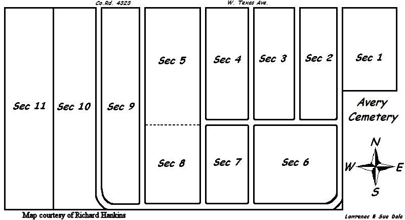
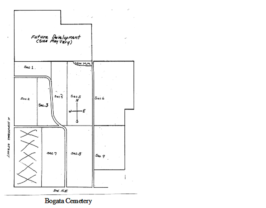
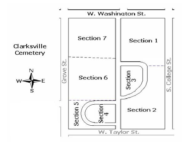
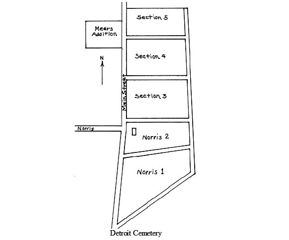
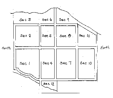